Thanks for submitting!
You will be contacted as soon as possible


Overview
This project, supported by USAID Bureau for Humanitarian Assistance (BHA), aims to enhance earthquake hazard modeling capabilities in small communities, as well as to provide better risk models to account for changes in the number of occupants, structures and economic value exposed to earthquakes and the adverse effects of climate change. The project will evaluate future earthquake risk losses, thus supporting decision makers with risk metrics that account for the expected evolution of the built environment, which are fundamental for the design and implementation of long-term risk reduction measures.


Objectives
The project aims to strengthen the capacities and understanding to manage and respond to future earthquake risk by:
introducing future growth or change into national and global exposure models to enable the quantification of future disaster losses, including those associated with climate change;
developing communication and dissemination tools to maximize the uptake of disaster risk information in policy making bodies; and
improving the reliability of earthquake hazard and risk assessment, in particular in regions that lack information.
To achieve the above, the project will implement five components below:
Predicting the evolution of the built environment and population
Forecasting future disaster risk due to earthquakes
Incorporating infrastructure in exposure modeling for risk assessment
Modeling earthquake hazard and risk for small communities
Advancing communication and dissemination of risk information
Collaborators
Funding partner:
USAID Bureau for Humanitarian Assistance (BHA)
El Salvador:
Science partner: University of El Salvador (contact Manual Menjivar, associate Professor).
Government partner: Ministerio de Medio Ambiente y Recursos Naturales, MARN (contacts Douglas Antonio Hernández, Geology Area Coordinator, and Luis Mixco, seismologist).
Nepal:
Science partner: National Society for Earthquake Technology, NSET (contact Surya Narayan Shrestha, Executive Director).
Government partner: National Disaster Risk Reduction and Management Authority (NDRRMA).
Bhutan:
Science partner: College of Science and Technology-Royal University of Bhutan (contact Chimi Wangmo, Head of Department, Civil Engineering DepartmentCheki Dorji).
Pacific partners:
Secretariat of Pacific Community (SPC), Geoscience, Energy and Maritime Division (contact Litea Biukoto, Geohazards Risk Management Leader)
Indian Ocean partner:
The Indian Ocean Commission IOC, (contact Gina Bonne, Director)
Government partners:
Member states and territories of the SPC and IOC through their representatives.
Additionally, collaboration is expected from GEM partners Geoscience Australia (GA) and Geological and Nuclear Sciences (GNS), New Zealand, considering their active role in the region.


Location
Bhutan, El Salvador, Nepal, and small communities in oceans

3. Forecasting Seismic Risk in El Salvador
How will seismic risk evolve in the next 30 years? This risk forecast presents two possible futures - one where risk remains high due to unregulated construction and another where proactive policies and seismic codes reduce vulnerabilities. The results underscore the importance of long-term planning for disaster resilience.
Pronostico_Riesgo
View details | Download

Seismic Risk Forecasting for a Safer El Salvador
The FORCE project assesses El Salvador’s seismic risk today and projects future impacts over the next 30 years under two scenarios: continuing current construction practices or fully adopting modern seismic codes. The findings highlight the urgent need for stronger building regulations to reduce economic and human losses.

2. Seismic Codes and Future Risk Scenarios
What role do building regulations play in disaster risk reduction? This study examines the impact of seismic codes on El Salvador’s future risk landscape. By comparing scenarios with and without strengthened regulations, the findings emphasize how improved construction practices can significantly reduce losses and enhance community resilience.
Codigo-Riesgo_Futuro
View details | Download

1. Historical Earthquakes and Their Destructive Potential
El Salvador has experienced numerous significant earthquakes, each shaping the country’s approach to disaster preparedness. This dashboard provides a comprehensive analysis of historical seismic events, highlighting their destructive potential and reinforcing the need for proactive risk management to reduce future impacts.
Eventos_históricos_potencial_destructivo_Dashboard_Luis_Mixco_PPT

OpenQuake Online Training
Language: Spanish
Upcoming session dates
Module II (part 1) February 6, 2024
Module II (part 2) February 20, 2024
Module III February 13, 2024
Module IV February 27, 2024
-----
OpenQuake Training: an online course for beginners
Language: English
Completed session dates
March 20, 2023
March 27, 2023
April 17, 2023
April 24, 2023
-----

Online and Onsite Training Workshops
This part of the program is designed to improve the understanding and awareness of earthquake hazards and risks and to help bridge the gap between the information produced in the project sites and its communication to a wide variety of stakeholders through online and onsite training workshops.
Under the FORCE project, Spring and Autumn OpenQuake training courses will be offered. Please check back regularly for the latest training activities.
Modules covered by the OpenQuake Online Training Courses
The online training Modules 2-4, discuss how to explore and prepare the required input files for earthquake scenarios, PSHA (such as hazard maps for different return periods, hazard curves, and uniform hazard spectra), and event-based risk analysis in the OpenQuake-engine, how to run an example and visualise the results. Module 1 OQ Introduction is a self-learning module available at training.openquake.org.

Advancing communication and dissemination of risk information
The activities in this component are focused on raising awareness of the public on earthquake hazard and risk by training a diverse group of disaster risk reduction (DRR) professionals together with personnel in charge of communicating risk to the public, and by conducting community-based workshops in the pilot countries.

SATIC Event, OpenQuake Conference, Cali Risk Assessment and Community Awareness Workshops
An event was held at the Banco de la República Auditorium in Cali, Colombia from November 21-25 to present seismic scenarios for Cali using Cali risk models; introduction of OpenQuake Tools; and training workshop for the use of the information repository and risk models, including awareness workshops for the community (local trainers, firefighters, civil defense).
Strengthening Bhutan's Resilience: GEM's Collaborative Efforts in Seismic Risk Reduction
Thimphu, Bhutan - March 15, 2024. The Global Earthquake Model (GEM) Foundation's USAID-supported project, Forecasting and Communicating Earthquake Hazard and Risk (FORCE), recently concluded a successful week of activities in Bhutan (March 11-15, 2024). Led by GEM's Alejandro Calderon and Catarina Costa, the project focuses on strengthening local capacities and improving earthquake risk reduction in the country (report with detailed information).

FORCE project: Groundwork activities gain strong support from local and national stakeholders in Nepal
GEM’s USAID-supported Forecasting and Communicating Earthquake Hazard and Risk (FORCE) project kicked off in Kathmandu, Nepal from February 20th to 24th by meeting local and national partners involved in disaster risk reduction activities in the country. A half-day introductory workshop for key project stakeholders on February 24th capped the groundwork activities. (report with detailed information)

PSHA for the Oceans Webinar
In this webinar, we explored the key features of the Global Seismic Hazard Mosaic and the PAC model, with a special focus on the ocean models in the Southwest Pacific. We presented GEM’s approach to building PSHA models that span vast regions, even in data-scarce areas. Additionally, we highlighted seismic hazard trends across the region, including insights for key population centers.
The recording and presentation are now available and can be accessed here: https://www.globalquakemodel.org/gemevents/psha-oceans-force-project

Workshop on Probabilistic Seismic Hazard Assessment (PSHA), Risk Analysis, and the OpenQuakeEngine at FEPADE in El Salvador
The Ministry of Environment and Natural Resources (MARN) of #ElSalvador and the GEM Foundation successfully concluded a workshop on Probabilistic Seismic Hazard Assessment (#PSHA), #Risk #Analysis, and the #OpenQuakeEngine at FEPADE in El Salvador, as part of the USAID - Bureau for Humanitarian Assistance-supported #FORCE #Project. This workshop substantially contributes to building local expertise in this crucial pilot project area, reinforcing El Salvador's #earthquake #resilience. We extend heartfelt thanks to our dedicated #local #partners for their invaluable contributions, pivotal in ensuring the success of this event!

Earthquakes in El Salvador: What Do We Know and How Could They Affect Us in the Coming Years?
GEM's FORCE project made notable developments in #ElSalvador last week. Various meetings and technical activities were conducted highlighted by a workshop that convened stakeholders to discuss the topic "#Earthquakes in El Salvador: What Do We Know and How Could They Affect Us in the Coming Years?" In collaboration with the USAID - Bureau for Humanitarian Assistance (USAID/BHA), and national partners Ministerio de Medio Ambiente y Recursos Naturales de El Salvador (MARN) and Dirección General de Protección Civil de El Salvador, this session marked a crucial step in advancing #seismic #risk #understanding and response capabilities.
Thanks to all for the productive discussions and active participation!

Online session on seismic hazard and risk assessment in the Pacific
Our FORCE project team successfully concluded an online session on seismic hazard and risk assessment in the #Pacific. With participation from 15 attendees representing 7 countries, the session explored Session 1 - Seismic #hazard and #risk information available in the Global Mosaic.
Attendees were informed of various #earthquake #hazard and #risk outputs within the GEM Foundation, such as hazard maps, hazard curves, uniform hazard spectra, #exposure models, #vulnerability and #fragility models, and risk metrics. Discussions also focused on what information is included in GEM’s Country Seismic Risk Profiles. These insights underscored the significance of #seismic #assessment in the region. Stay tuned for updates on future sessions! #FORCEProject #SeismicAssessment #GEMFoundation

Strengthening Pacific Resilience: Highlights from the Workshop
GEM concluded a successful two-day training workshop in Suva, Fiji, as part of the FORCE project. Held on November 18-19, the workshop focused on understanding earthquake hazard and risk in the Southwest Pacific - a region highly vulnerable to seismic activity.
Facilitated by GEM’s Catalina Yepes Estrada, Exposure Development Lead, and Kendra Johnson, Senior Seismic Hazard Scientist, the training brought together local stakeholders and experts to explore practical approaches to earthquake risk assessment and disaster preparedness.
Participants engaged in hands-on exercises using GEM’s OpenQuake engine, explored probabilistic seismic hazard and risk analysis, and discussed ways to improve resilience through better data and modeling. A key takeaway was the importance of tailoring risk models to local needs, with opportunities for participants to share insights on addressing data and resource challenges unique to the Pacific region.
The workshop was held alongside the STAR Conference, where GEM also presented on leveraging hazard and risk models for sustainable development and disaster risk reduction.
A big thank you to all participants for their active engagement and to our partners - the Mineral Resources Department (MRD) in Fiji, the Pacific Community (SPC), UNESCO, and the USAID Bureau for Humanitarian Assistance, GEM's funding partner for the FORCE project - for their collaboration in making this event possible. These shared efforts are crucial as we work toward a safer and more resilient future for communities in the Pacific.

Luis Mixco and GEM’s Cata Yepes Featured on El Salvador’s National News
El Salvador’s Ministry of Environment has launched a new tool designed to quickly estimate earthquake damage, enabling a faster response to affected communities. Watch as Luis Mixco, Ministry of Environment and Natural Resources of El Salvador, and GEM’s Cata Yepes discuss this important development in a national news segment.

New GEM-USAID Project Forecasting and Communicating Earthquake Hazard and Risk (FORCE) launched
On the heels of the successful completion of the TREQ project partnership this year, GEM and USAID Bureau for Humanitarian Assistance (BHA) are embarking on a new project called Forecasting and Communicating Earthquake Hazard and Risk or FORCE. The project aims to strengthen the capacities and understanding to manage and respond to future earthquake risk.

FORCE Project Updates: City Zonation workshops
Our sessions with USAID focused on city zonation for #emergencyresponse in #Medellin, followed by a workshop communicating #seismic #risk to first responders in our ongoing collaboration with Universidad EAFIT, #SIATA - Sistema de Alerta Temprana del Valle de Aburrá, and #AMVA - Área Metropolitana del Valle de Aburrá. These initiatives are fundamental in enhancing emergency preparedness efforts.
#EmergencyPreparedness #SeismicRiskCommunication

A Resilient Future: Embracing Innovation and Leveraging Local Expertise and Collaboration to Enhance Seismic Risk Reduction in El Salvador
The Global Earthquake Model (GEM) Foundation's USAID-supported project, Forecasting and Communicating Earthquake Hazard and Risk (FORCE), has been working to help strengthen local capacities and improve earthquake risk reduction in El Salvador. The project has conducted two visits to the country, bringing together government agencies, scientists, engineers, and other stakeholders to discuss seismic hazard assessment, risk analysis, and communication strategies (report with detailed information).

FORCE Project Update: Predicting Urban Growth and Population Evolution
One critical component of this project involves predicting urban growth and population evolution. This involves analysing more than 20 potential drivers of urban development over several decades. These encompass factors such as demographic trends, economic metrics, and land-use patterns. The FORCE team is actively developing urban growth models utilising techniques like regression analysis and machine learning. Currently, these models are undergoing meticulous evaluation to ensure their ability to replicate observed increases in dwelling numbers and construction areas.
BUSINESS NEWS
Medellin Workshops December 2023 with AMVA
Workshops on city zonation for #emergencyresponse in #Medellin, followed by a workshop communicating #seismic #risk to first responders in our ongoing collaboration with Universidad EAFIT, #SIATA - Sistema de Alerta Temprana del valle de Aburrá, and #AMVA - Área Metropolitana del Valle de Aburrá.


BUSINESS NEWS
El Salvador Meetings January 9, 2024
Meetings with the Protección Civil de El Salvador.


BUSINESS NEWS
Activities in Bhutan (March 11-15, 2024)
A series of technical meetings and workshops on the FORCE project in Bhutan was held from the 11th to the 15th of March 2024.


BUSINESS NEWS
El Salvador Stakeholder Workshop January 11, 2024
Earthquakes in El Salvador: What Do We Know and How Could They Affect Us in the Coming Years?


BUSINESS NEWS
El Salvador November 2023 Workshop
Introduction to Probabilistic Seismic Hazard (PSHA) and Risk Analysis and the OpenQuake Engine with MARN hosted by the Fundación Empresarial para el Desarrollo Educativo (FEPADE) November 6-10, 2023.


BUSINESS NEWS
Strengthening Pacific Resilience: Highlights from the Workshop - November 18-19, 2024, Suva, Fiji
GEM concluded a successful two-day training workshop in Suva, Fiji, as part of the FORCE project. Held on November 18-19, the workshop focused on understanding earthquake hazard and risk in the Southwest Pacific - a region highly vulnerable to seismic activity.


BUSINESS NEWS
SATIC event in Cali, Colombia Nov 21-25, 2022


BUSINESS NEWS
Kick-off meetings in Nepal
The launch meetings of the FORCE project – Forecasting and Communicating Earthquake Hazard and Risk were held in the city of Kathmandu, Nepal, from 20th to 24th February 2023.


BUSINESS NEWS
Workshop summarising the USAID-supported initiative in El Salvador led by GEM’s local partners, January 21-24, 2025
The activities focused on sharing and communicating the project's outcomes, including updated earthquake hazard and risk models, impact metrics, and capacity-building activities. GEM's Alejandro Calderon and Catalina Yepes-Estrada joined as participants to share insights on project outcomes, tools, and lessons learned with stakeholders.


Similar to the TREQ project, reports and publications relevant to each of the FORCE project components will be produced and published in due course. This page is dedicated to this purpose.

Pronostico y Comunicacion de Riesgos por Terremotos
Visitas técnicas en El Salvador
EL proyecto FORCE: Pronóstico y comunicación de la amenaza y el riesgo de terremotos (Forecasting and Communicating Earthquake Hazard and Risk por sus siglas en inglés), realizó dos visitas a El Salvador con el objetivo de fortalecer las capacidades locales y la comunicación de los resultados de riesgo sísmico a las diferentes entidades que forman parte de la prevención, gestión y respuesta ante terremotos destructivos en el país. De la mano del Ministerio de Medio Ambiente y Recursos Naturales (MARN) se realizaron talleres y reuniones con diferentes actores del sector público como Protección Civil, Ministerio de Obras Públicas, Fondo de Conservación Vial de El Salvador, Cuerpo de Bomberos, Ministerio de Educación, Instituto Salvadoreño del Seguro Social, Oficina de Planificación del Área Metropolitana de San Salvador (OPAMSS), entre otros.
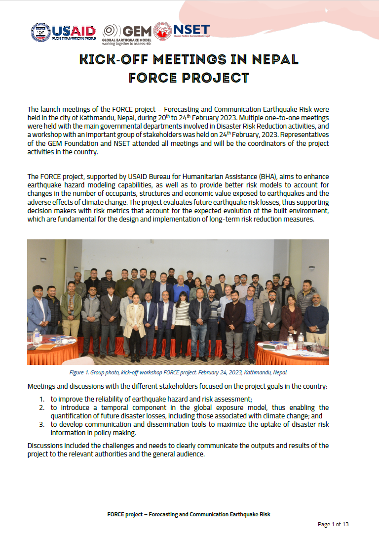
Kick-off meetings in Nepal FORCE Project
The launch meetings of the FORCE project – Forecasting and Communication Earthquake Risk were held in Kathmandu, Nepal, from 20th to 24th February 2023. Multiple one-to-one meetings were held with the main governmental departments involved in Disaster Risk Reduction activities, and a workshop with an important group of stakeholders was held on 24th February 2023. Representatives of the GEM Foundation and NSET attended all meetings and will be the coordinators of the project activities in the country.
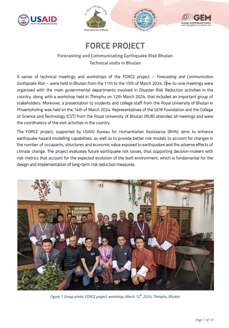
Forecasting and Communicating Earthquake Risk - Bhutan
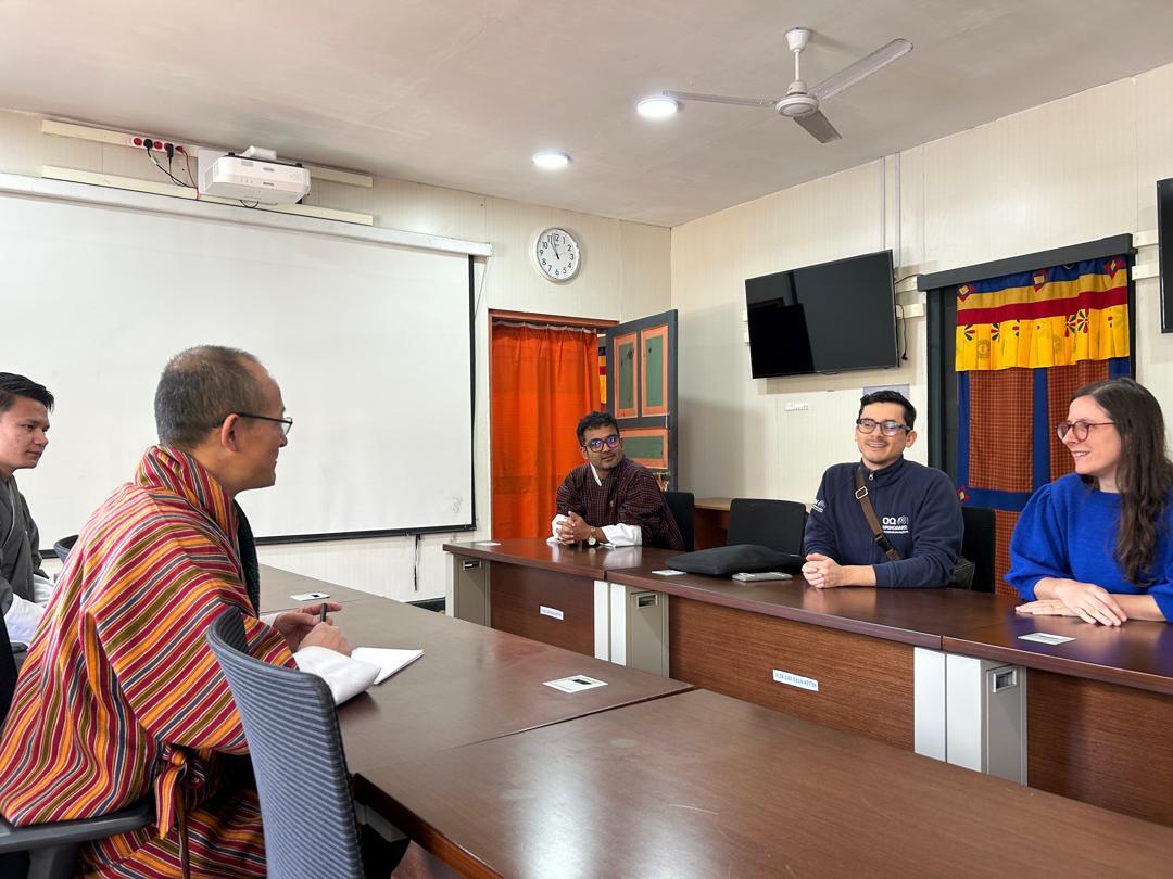
Technical Visits in Bhutan
A series of technical meetings and workshops of the FORCE project – Forecasting and Communication Earthquake Risk – were held in Bhutan from the 11th to the 15th of March 2024. One-to-one meetings were organised with the main governmental departments involved in Disaster Risk Reduction activities in the country, along with a workshop held in Thimphu on 12th March 2024, that included an important group of stakeholders. Moreover, a presentation to students and college staff from the Royal University of Bhutan in Phuentsholing was held on the 14th of March 2024. Representatives of the GEM Foundation and the College of Science and Technology (CST) from the Royal University of Bhutan (RUB) attended all meetings and were the coordinators of the visit activities in the country.
Disclaimer
The contents of this project website such as studies, reports, audio-visual, news articles, blogs, and other information or media products including those in the external links are made possible by the generous support of the American people through the United States Agency for International Development (USAID). The contents are the responsibility of the Global Earthquake Model (GEM) Foundation and do not necessarily reflect the views of USAID or the United States Government.