top of page
Thanks for submitting!
You will be contacted as soon as possible


Featured Publications

Development of a global seismic risk model

GEM Strategic Plan and Roadmap to 2030

Improving Post-Disaster Damage Data Collection to Inform Decision-Making Final Report
Anchor 1
Publications List
0
Sort by Title:
Download
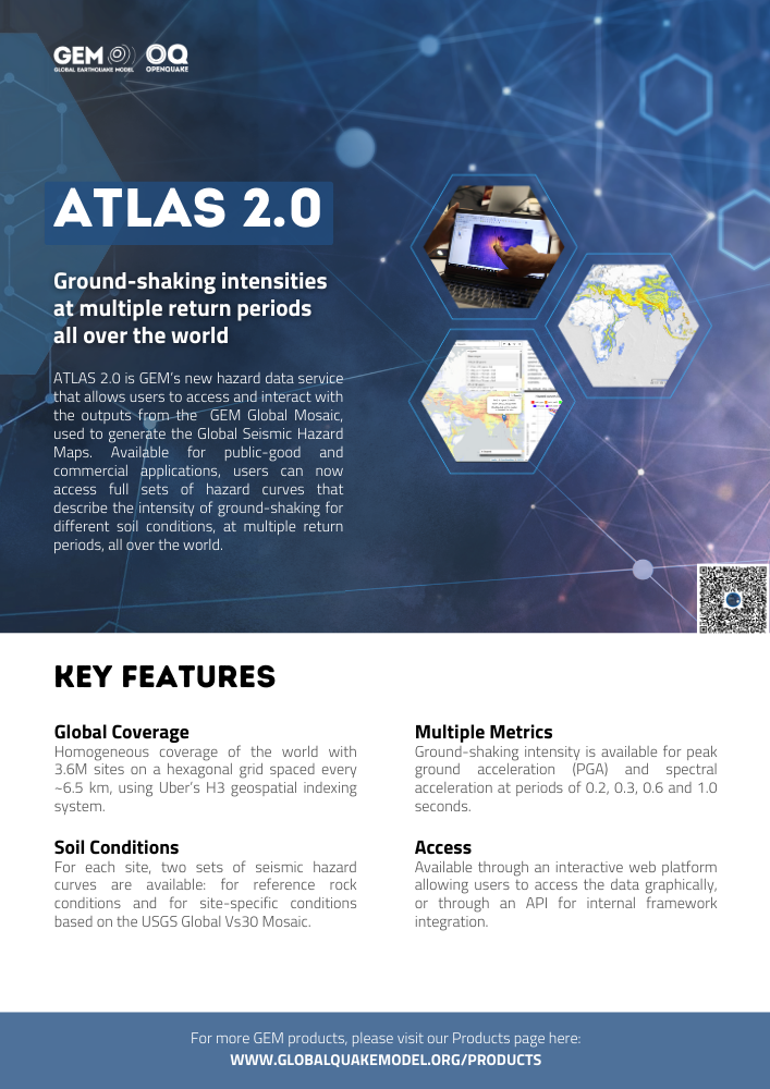
ATLAS 2.0: Ground-shaking intensities at multiple return periods all over the world
Type:
Brochure
Year:
2024
ATLAS 2.0 is GEM’s new hazard data service that allows users to access and interact with the outputs from the GEM Global Mosaic, used to generate the Global Seismic Hazard Maps. Available for public-good and commercial applications, users can now access full sets of hazard curves that describe the intensity of ground-shaking for different soil conditions, at multiple return periods, all over the world.
Download
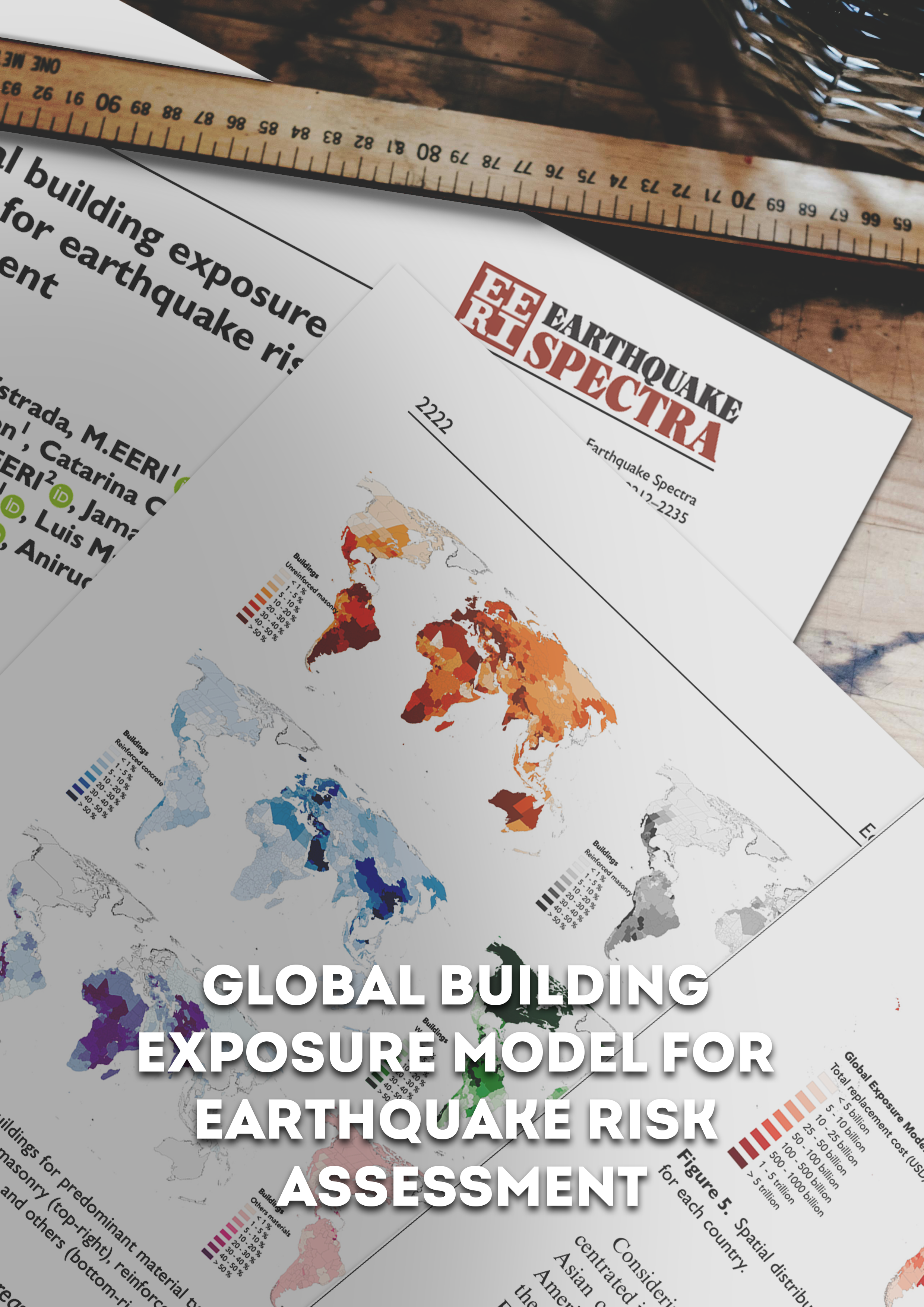
Global building exposure model for earthquake risk assessment
Type:
Peer-reviewed
Year:
2023
The global building exposure model is a mosaic of local and regional models with information regarding the residential, commercial, and industrial building stock at the smallest available administrative division of each country and includes details about the number of buildings, number of occupants, vulnerability characteristics, average built-up area, and average replacement cost. We aimed for a bottom-up approach at the global scale, using national statistics, socio-economic data, and local datasets. This model allows the identification of the most common types of construction worldwide, regions with large fractions of informal construction, and areas prone to earthquakes with a high concentration of population and building stock. The mosaic of exposure models presented herein can be used for the assessment of probabilistic seismic risk and earthquake scenarios. Information at the global, regional, and national levels is available through a public repository (https://github.com/gem/global_exposure_model), which will be used to maintain, update and improve the models.
Download
Development of a global seismic risk model
Type:
Peer-reviewed
Year:
2020
The Development of a Global Seismic Risk Model was a mammoth undertaking that involved hundreds of people and for the first time presented a detailed view of seismic risk at the global scale. For some developing countries, this was the first time that a seismic risk map was produced, and the associated country profiles are being used by the local authorities.

Download
GEM Strategic Plan and Roadmap to 2030
Type:
Brochure
Year:
2022
GEM was founded in 2009 with the purpose of improving the global knowledge of earthquake risk and contributing to the reduction of risk worldwide. In 13 years, GEM has become widely known for its global effort to improve the state of practice of earthquake hazard and risk assessment and for its contribution to improving the state of knowledge of earthquake risk.
Download
Exploring benefit cost analysis to support earthquake risk mitigation in Central America
Type:
Peer-reviewed
Year:
2022
We performed benefit-cost analysis to identify optimum retrofitting interventions for the two most vulnerable building typologies in Central America, unreinforced masonry and adobe, considering the direct costs due to building damage and the indirect costs associated with the injured and fatalities. We reviewed worldwide retrofitting techniques, selected those that could be applied in the region for these building types, and derived vulnerability functions considering the impact of each retrofitting intervention in the strength, stiffness, and ductility of the structures. Probabilistic seismic risk analyses were performed considering the original configuration of each building class, as well as the retrofitted version. We calculated average annual losses to estimate the annual savings due to the different structural interventions, and benefit cost ratios were estimated based on the associated cost of each retrofitting technique. Based on the benefit-cost analyses, for a 50-year time horizon and a 4% discount rate, retrofitting these building classes could be economically viable along the western coast of Central America.
Download
The adolescent years of seismic risk assessment
Type:
Peer-reviewed
Year:
2022
Vitor Silva reflects on the current position of seismic risk assessment compared to its hazard counterpart, and posits that this discipline is expected to become common practice in disaster risk management, providing decision makers with valuable information not just about the current threat, but also how the impact of future disasters is expected to evolve. The growth of seismic risk assessment into its adult years will allow a more efficient design and implementation of risk mitigation measures. ultimately contributing to its main and only goal: the reduction of the human and economic losses caused by earthquakes.

Download
Exposure forecasting for seismic risk estimation: Application to Costa Rica
Type:
Peer-reviewed
Year:
2021
This study proposes a framework to forecast the spatial distribution of population and residential buildings for the assessment of future disaster risk. The approach accounts for the number, location, and characteristics of future assets considering sources of aleatory and epistemic uncertainty in several time-dependent variables. The value of the methodology is demonstrated at the urban scale using an earthquake scenario for the Great Metropolitan Area of Costa Rica. Hundreds of trajectories representing future urban growth were generated using geographically weighted regression and multiple-agent systems. These were converted into exposure models featuring the spatial correlation of urban expansion and the densification of the built environment. The forecasted earthquake losses indicate a mean increase in the absolute human and economic losses by 2030. However, the trajectory of relative risk is reducing, suggesting that the long-term enforcement of seismic regulations and urban planning are effectively lowering seismic risk in the case of Costa Rica.

Download
Investment in Disaster Risk Management in Europe Makes Economic Sense
Type:
Report
Year:
2021
The physical, financial, and social impacts of
disasters in Europe are growing and will continue to
grow unless urgent actions are taken. In the European
Union (EU), during the period from 1980 to 2020,
natural disasters affected nearly 50 million people and
caused on average an economic loss of roughly €12
billion per year (EEA, 2020). The impacts of flood,
wildfire, and extreme heat are increasing rapidly, and
climate damages could reach €170 billion per year
according to conservative estimates for a 3 scenario
unless urgent action is taken now (Szewczyk, et al.,
2020). Earthquakes, while rare, have a devastating
impact on the ageing buildings and infrastructure of
Europe that were constructed prior to modern codes;
in Bucharest, for example, nearly 90% of the population
lives in multifamily buildings with pre-modern building
codes3 (Simpson & Markhvida, 2020). Within the EU,
the top-five countries with the highest annual average
loss to earthquake are Cyprus, Greece, Romania,
Bulgaria, and Croatia, and for floods the top-five
countries are Romania, Slovenia, Latvia, Bulgaria, and
Austria.4 However, disasters do not affect everyone
equally: poor, elderly, very young, and marginalized
populations are most affected and least able to recover.
In Romania, Greece, Croatia, and Bulgaria, for example,
the socio-economic resilience of the poor is on average
less than 30% of the national average (World Bank,
2020). Moreover, the local and regional administrations
in the poorer and more disadvantaged areas have the
least capacity to design and implement resilience
investments.
Title | Year | Type | Topic | Journal |
|---|---|---|---|---|
ATLAS 2.0: Ground-shaking intensities at multiple return periods all over the world | 2024 | Brochure | Hazard | |
Quantify Your Earthquake Risk: Expert Solutions from the GEM Foundation | 2024 | Brochure | Products | |
Building a World Resilient to Earthquakes and other Natural Hazards | 2024 | Brochure | GEM | |
Global building exposure model for earthquake risk assessment | 2023 | Peer-reviewed | Exposure | Earthquake Spectra |
Development of a global seismic risk model | 2020 | Peer-reviewed | Risk | Bulletin of Earthquake Engineering |
GEM Strategic Plan and Roadmap to 2030 | 2022 | Brochure | GEM | |
Exploring benefit cost analysis to support earthquake risk mitigation in Central America | 2022 | Peer-reviewed | Risk | International Journal of Disaster Risk Reduction |
The adolescent years of seismic risk assessment | 2022 | Peer-reviewed | Risk | Natural Hazards |
Exposure forecasting for seismic risk estimation: Application to Costa Rica | 2021 | Peer-reviewed | Exposure | Earthquake Spectra |
Investment in Disaster Risk Management in Europe Makes Economic Sense | 2021 | Report | Risk |
bottom of page