Thanks for submitting!
You will be contacted as soon as possible


QUICK LINKS


PROFILES
PUBLICATIONS
EXPOSURE
VULNERABILTY
SOFTWARE
EQ MODELS
Search Results
1077 results found with an empty search
- GEM renews its commitment to help achieve the goals of the Sendai Framework by 2030 - GEM Foundation
News GEM renews its commitment to help achieve the goals of the Sendai Framework by 2030 By: Jul 31, 2019 Share Facebook LinkedIn The Global Earthquake Model (GEM) Foundation has renewed its Sendai Framework Voluntary Commitment (VC) to increase earthquake risk understanding and resilience globally. Under the Sendai Framework VC, GEM is committed to continue developing, communicating and facilitating the use of earthquake hazard, risk and social vulnerability tools and information to contribute to the achievement of the four priorities of action of the UNDRR’s Sendai Framework by 2030 . The Voluntary Commitments initiative, was developed in response to the UN General Assembly resolution 68/211 (2013) and launched in the lead-up to the World Conference for Disaster Risk Reduction (WCDRR) in March 2015 to support the development of partnerships at all levels to implement the Sendai Framework. GEM made its first commitment during the WCDRR in Sendai City, Miyagi Prefecture, Japan. UNDRR has established an online platform as a mechanism to mobilize, monitor and take stock of commitments from multi-stakeholders for the implementation of the Sendai Framework until 2030. Since its launch in December 2018, a number of stakeholders have already showcased their efforts to build resilient societies by publishing and monitoring Voluntary Commitments (VCs) in support of the implementation of the Sendai Framework through the SFVC online platform. To learn more on how to participate in this initiative, visit https://sendaicommitments.unisdr.org . No images found. GALLERY 1/0 VIDEO RELATED CONTENTS FACT BOX
- METEOR Project: successful completion produced useful, scientifically sound, accessible and cost-efficient data and protocols - GEM Foundation
News METEOR Project: successful completion produced useful, scientifically sound, accessible and cost-efficient data and protocols By: Jun 3, 2021 Share Facebook LinkedIn Photo credit: METEOR Project After three years, the METEOR project, a consortium led by the British Geological Survey, has come to a successful conclusion, delivering all the expected outputs for pilot countries Nepal and Tanzania. The project aimed to formulate an innovative methodology of creating quality data and models that can be used to improve decision-making in disaster risk management (DRM) through the use of earth observation or EO-based imagery to identify development patterns throughout a country. The results include EO-based exposure data for 47 ODA countries ; protocols and standards for developing locally calibrated exposure data (tested and validated in Nepal and Tanzania); and capacity development of core stakeholders. These results are expected to promote welfare and economic development in the pilot and 47 ODA countries, and demonstrate the applicability of the techniques elsewhere. For planning, the data and protocols developed can help municipalities to identify areas with high landslide susceptibility, and the corresponding risk to buildings located in those areas. In emergency response, such as after an earthquake, municipalities can identify the following: low hazard areas where people can be moved to safety, where the biggest impacts are likely to be and where to focus land-use planning and building retrofitting efforts. GEM contributions GEM, a member of the consortium, contributed to two work packages: structural vulnerability assessment and propagation of uncertainty to disaster risk estimates for multiple perils including earthquakes, landslides, floods, and volcanoes; and knowledge sharing and dissemination of project outputs and protocols through the use of web portals and training workshops with local partners. In Tanzania, GEM, HOT, and DMD co-led an earthquake scenario demonstration and walkthrough workshops. A hypothetical M7.0 earthquake offshore Dar es Salaam was modelled, investigating the potential impacts of the 2020 M6.0 earthquake near Dar es Salaam had it been stronger. Using these impact estimates, stakeholders organized into 3 separate groups to determine their ministry's role in response, discuss how certain challenges to response might be overcome, and identify data that could be helpful to respond. In Nepal, GEM led workshop sessions on seismic hazards and risk, which included an overview of the theory and methodology pertaining to seismic hazard assessment (both scenario-based and probabilistic), exposure considerations specific to earthquake hazards, vulnerability modelling, and risk analysis and metrics. GEM also assisted project partners that are leading other work packages, including the construction of improved building vulnerability models for buildings with some retrofit or other seismic intervention. This work informed a cost-benefit analysis that can be used to indicate the return-on-investment of seismic mitigation strategies. METEOR Partners Other members of the consortium included Fathom (flood hazard model), Oxford Policy Management (OPM) (project monitoring and management), ImageCat (EO-based data for exposure development, methods and protocols, and training), The Humanitarian OpenStreetMap Team (HOT) (exposure data in Kathmandu and Dar es Salaam for validation and calibration of building patterns from EO-based imagery), National Society for Earthquake Technology (NSET) in Nepal,and the Disaster Management Department (DMD) of the Prime Minister’s Office of Tanzania - key to the co-development of the country datasets. Important links: The training portal on the METEOR website (for Nepal and Tanzania) The maps portal on the METEOR website (exposure and hazard data) Nepal BIPAD portal containing METEOR data/maps (the official DRR data portal of Nepal) Related links: HOT Tanzania Workshop article HOT Field data in Kathmandu NASA Applied Sciences No images found. GALLERY 1/0 Gallery VIDEO RELATED CONTENTS FACT BOX
- GEM METEOR project releases exposure datasets for more than 40 countries - GEM Foundation
News GEM METEOR project releases exposure datasets for more than 40 countries By: Nov 25, 2020 Share Facebook LinkedIn The METEOR Project celebrated UNDRR’s recent International Day for Disaster Risk Reduction by releasing exposure data for 44 Official Development Assistance (ODA) recipient countries, including the corresponding interactive maps. The objective of the project is to formulate an innovative methodology of creating exposure data through the use of Earth Observation (EO)-based imagery to identify development patterns throughout a country. The METEOR protocols and standards for combining traditional land use interpretation methods with EO and in-field building characteristics to capture the distribution of building types have been pilot tested in Nepal and Tanzania. Specifically, the project aims to deliver exposure data for 47 of the least developed ODA countries, ; to create hazard footprints for the pilot countries Nepal and Tanzania; to create open protocols showing how to collect data and apply techniques in other countries; and to build capacity of local stakeholders to apply data and assess hazard exposure. The project is expected to benefit a wide spectrum of stakeholders such as governments, NGOs, affected communities and businesses, seeking to bolster resilience and growth. To download the data visit, . To view interactive maps of the data, visit . No images found. GALLERY 1/3 Gallery VIDEO RELATED CONTENTS FACT BOX
- An online OpenQuake Training course for beginners - GEM Foundation
News An online OpenQuake Training course for beginners By: Jun 28, 2023 Share Facebook LinkedIn The FORCE project recently conducted an online OpenQuake Training course tailored for beginners seeking to enhance their understanding of earthquake risk assessment. The training, which spanned from March 20 to 27 and April 17 to 24, comprised modules that delved into various aspects of earthquake scenarios, such as exploring and preparing the necessary input files, as well as conducting probabilistic seismic hazard analysis (PSHA) and event-based risk analysis using the OpenQuake engine. The course was crafted to accommodate participants from diverse backgrounds and expertise levels, aiming to provide a comprehensive overview of earthquake risk assessment and familiarize attendees with the fundamental features of the OpenQuake engine. Divided into four sessions, each lasting three hours, the training covered essential concepts related to earthquake hazard and risk assessment using the OpenQuake engine. To supplement the course material, Module I, titled OQ Introduction, was made available as a self-learning module on the training.openquake.org platform. This additional resource allowed participants to gain preliminary knowledge and ensure a solid foundation before delving into the subsequent modules. The OpenQuake Training provided an invaluable opportunity for beginners to acquire new skills and insights in the field of earthquake risk assessment. By equipping participants with the necessary tools and knowledge, the course aimed to empower them to contribute effectively to earthquake resilience and disaster mitigation efforts. No images found. GALLERY 1/0 VIDEO RELATED CONTENTS FACT BOX
- Estimating fault slip rates in the Cascadia region of North America using joint geologic-geodetic block modeling - GEM Foundation
News Estimating fault slip rates in the Cascadia region of North America using joint geologic-geodetic block modeling By: Jun 3, 2021 Share Facebook LinkedIn Richard Styron, GEM hazard team, was recently invited to present at the Seismological Society of America (SSA) Conference held in April on the ongoing collaborative research between GEM, Natural Resources Canada, and other scientists to study earthquake faults in the northwestern US and western Canada. The authors of the conference paper were Richard Styron, Tiegan Hobbs (Natural Resources Canada), Zach Lifton (Idaho Geological Survey), Nick Harrichhausen (University of California, Santa Barbara) and Murray Journeay (Natural Resources Canada). The project uses a software program developed by Richard called Oiler , that estimates the long-term movement of faults and corresponding production of earthquakes. Oiler uses geodetic (mostly global positioning system or GPS) measurements of the movement of tectonic plates, as well as geologic data such as geologic mapping and paleoseismic studies, to solve for the slip rate (and therefore earthquake production rate) of all faults within a fault network. For this project, the researchers used existing fault data augmented with some new mapping in the US, and completely new mapping of possibly-active faulting in Canada, to build the fault network. Over the next year or two, the researchers hope to be able to incorporate all of this data into a comprehensive database of seismically active faults in order to evaluate the earthquake potential of previously-unstudied faults in western Canada and the northwestern US. Watch Richard’s SSA presentation here. [ VIDEO LINK ] About #SSA2021 Held on 19–23 April 2021, the virtual SSA Annual Meeting featured more than 750 technical presentations, including sessions co-sponsored by the Latin American and Caribbean Seismological Commission and the Seismological Society of China. For more about SSA, visit https://www.seismosoc.org/ . No images found. GALLERY 1/0 Gallery VIDEO RELATED CONTENTS FACT BOX
- Using the lessons from COVID19: Getting ready for earthquakes in the future - GEM Foundation
News Using the lessons from COVID19: Getting ready for earthquakes in the future By: May 21, 2020 Share Facebook LinkedIn Even though the COVID19 pandemic is not over yet, this catastrophic event has already taught us a lot; so, we tried to reflect on the lessons that could be drawn and carried into the future to reduce earthquake risk. Recently, GEM has completed a short social media campaign on the lessons learned from the COVID-19 that can be used in dealing with future earthquake risk. In case you missed it, here they are: 1) There is a need to strengthen open and transparent cooperation among the scientific community, businesses and political leaders. Especially in our field of work, dealing with an earthquake disaster that encompasses nations and regions, implementing science-based solutions will need economic and political will. 2) There is a need to develop a stronger system that can quickly translate scientific knowledge into practical and workable mitigation and emergency response strategy at the local and community level. 3) There is a need for governments and institutions to provide the population with simple, clear and understandable information and to take active actions against fake news and misinformation. 4) There is a need to reorganize, restructure, refocus, and ‘retrofit’, so to speak, our global institutions to become more efficient and readier in dealing with future risks such as earthquakes, pandemics and any disaster that can endanger human lives. 5) There is a need to urgently finance research and development before the next global crisis occurs. Investing in scientific research and development plays a critical role in addressing the challenges in understanding, assessing and responding to the time-dependent nature of disaster risk. Moreover, sustained preparedness and awareness are pivotal for reducing risk from natural hazard events and for ensuring that people can act on warning in timely and appropriate ways. However, in order to achieve them, significant financial, human and material resources are needed at the national, regional and international levels before, during and after disasters. To sum it all up, before the next global disaster or crisis occurs, greater efforts are still needed in order to clearly communicate: science-based disaster risk assessments, socio-economic impacts, evaluations of mechanisms for risk reduction, and prescriptive options for translating scientific findings into practice. Here at GEM we will always work to do our part and give our contribution with openness, collaboration, commitment to science and a special focus on serving the public good. No images found. GALLERY 1/5 Gallery VIDEO RELATED CONTENTS FACT BOX
- Round up of GEM activities and participation in recent events (July - August) - GEM Foundation
News Round up of GEM activities and participation in recent events (July - August) By: Jul 2, 2018 Share Facebook LinkedIn During the last two months, GEM participated in various meetings across the globe. Here’s a list of GEM’s participation in some notable gatherings: GEM meets Community Safety Branch - Geoscience Australia in Canberra (July 25) GEM represented by John Schneider met with Geoscience Australia (GA) Community Safety Branch to discuss issues associated with earthquake hazard and risk modeling and to explore areas of mutual interest for potential collaboration. GA is currently completing a new national earthquake hazard model for Australia and has provided assistance to the Government of Indonesia in developing a new national earthquake hazard model for Indonesia using OpenQuake. John also travelled to Perth Australia with Mark Edwards and Maruf Rahman to meet Western Australia Department of Fire and Emergency Services together with lifeline system (transportation, electric power and water distribution) providers as part of a new collaborative project on earthquake vulnerability and risk to lifelines in Western Australia. GEM participates in US earthquake risk reduction discussion in London (July 7) GEM represented by Vitor Silva participates in discussion panel on earthquake risk model for the United States at Lloyds of London with RMS, AIR Worldwide, EPICentre UCL, Imperial College and Aon Benfield. The meeting held on July 7 in London was attended by around 160 participants. The panel discussion provided an opportunity for GEM to highlight the work recently completed by GEM, and funded by the California Seismic Safety Commission, on GEM’s OpenQuake risk model for the United States, which includes latest earthquake hazard model for California (UCERF3) as part of the USGS 2014 national hazard model. GEM meets FM Global in Boston (July 24) In Boston, USA GEM, represented by Marco Pagani, meets with FM Global to discuss global hazard modelling and the OpenQuake engine. The focus of the discussions was on FM Global’s contribution to the development of a global earthquake fault database. GEM at earthquake symposium in Lenzburg, Switzerland (5-7 September) Marco Pagani delivered an invited presentation on earthquake hazard modeling in Europe at the Probabilistic Seismic Hazard Assessment Workshop in Lenzburg, Switzerland. The workshop was convened by GEM sponsor ETH to review the state of the art and define future directions for earthquake hazard research in Europe. The workshop was attended by 150 leading experts on Probabilistic Seismic Hazard Assessment (PSHA) from around the globe. GEM at OASIS Modelling Conference in London (4-5 September) John Schneider was a guest at the first annual conference of the OASIS Loss Modellng Framework. OASIS is a consortium of organisations with common interests in developing and applying natural catastrophe risk models to insurance risk issues. About 200 model developers, users and risk management professionals attended the conference. GEM global databases and OpenQuake modeling tools featured prominently in presentations and discussions of earthquake risk modeling developments and applications. Many participants expressed interest in having GEM risk models accessible through the OASIS platform. No images found. GALLERY 1/0 VIDEO RELATED CONTENTS FACT BOX
- GEM at Jornadas de Amenaza y Riesgo Sísmico 2018 in Bogotá, Colombia - GEM Foundation
News GEM at Jornadas de Amenaza y Riesgo Sísmico 2018 in Bogotá, Colombia By: Jul 2, 2018 Share Facebook LinkedIn From February 19th to 21st, the GEM Foundation was hosted by the Colombian Geological Service during their Jornadas de Amenaza y Riesgo Sísmico 2018, three days dedicated to discuss seismic hazard and risk assessment, and its application in structural design and building code regulations. One full day was also dedicated to GEM’s OpenQuake engine. More than 220 people attended the event, among whom were hazard and risk modelers, public and private stakeholders, and students of Engineering and Earth Science. To open the three-day workshop, Dr Óscar Eladio Paredes, Director General of the SGC said. “We take the challenge of knowing the seismic hazard and risk as rigorously as possible. Likewise, we are aware that knowledge does not come from a single institution, and this implies a greater challenge, and that is to build it with the contribution of an open and participative technical community. This approach has allowed the Geological Service to explore novel methodologies and establish alliances with national and international experts for the development of a national seismic hazard model, which we have developed jointly with the GEM Foundation (Global Earthquake Model) during the last two years.” On February 19th, during the session “De la amenaza sísmica al diseño sismo resistente” session (“From seismic hazard to seismic resistant design”), Julio García, Senior Hazard Scientist at GEM, in collaboration with the Colombian Geological Service, presented the new seismic hazard model for Colombia, also sharing methodological aspects, results and application of the model. The afternoon sessions dealt with the use of national hazard models for structural design of infrastructure, new methodologies for risk assessment on buildings, and the use of active faults in seismic hazard analysis. During the last session, in addition to the participants, professionals from Geoestudios (Ecuador), Universidad del Norte (Colombia), Sociedad Colombiana de Geotecnia, Universidad de San Luís (Argentina) and Universidad Eafit (Colombia) were involved in a debate on the state of knowledge of seismic resistant design and the prospects for Colombia. On February 20th, the sessions were dedicated to seismic risk assessment. Public and private, as well as national and international authorities, addressed many issues related to comprehensive risk management, among which were the elaboration of exposure models for Colombia, financial risk management for disaster risk reduction - presented by the Treasury Department, and safe and sustainable construction. In the afternoon of February 20th and on the 21st, GEM carried out a workshop called “Evaluación del riesgo sísmico usando OpenQuake” (“Seismic risk assessment using OpenQuake”), facilitated by the GEM risk team. During the event, participants experienced first hand how to use OpenQuake, in particular the use of data to calculate seismic risk, the procedure to evaluate and describe inputs for the analysis of loss and damage scenarios, and in general, how to measure seismic risk. Workshops on the OpenQuake engine are particularly welcomed in countries like Colombia, where learning how to assess seismic risk is considered essential. The Universidad Nacional de Colombia mentions the GEM workshop in this article: https://agenciadenoticias.unal.edu.co/detalle/article/estudiantes-aprenden-a-calcular-amenaza-sismica-con-openquake.html GEM and SGC are committed to continue its strong collaboration to further advance seismic hazard and risk assessment in the country and the region. No images found. GALLERY 1/0 VIDEO RELATED CONTENTS FACT BOX
- Making Seismic Risk Information Open and Accessible: A Collaboration Between PreventionWeb and GEM Foundation - GEM Foundation
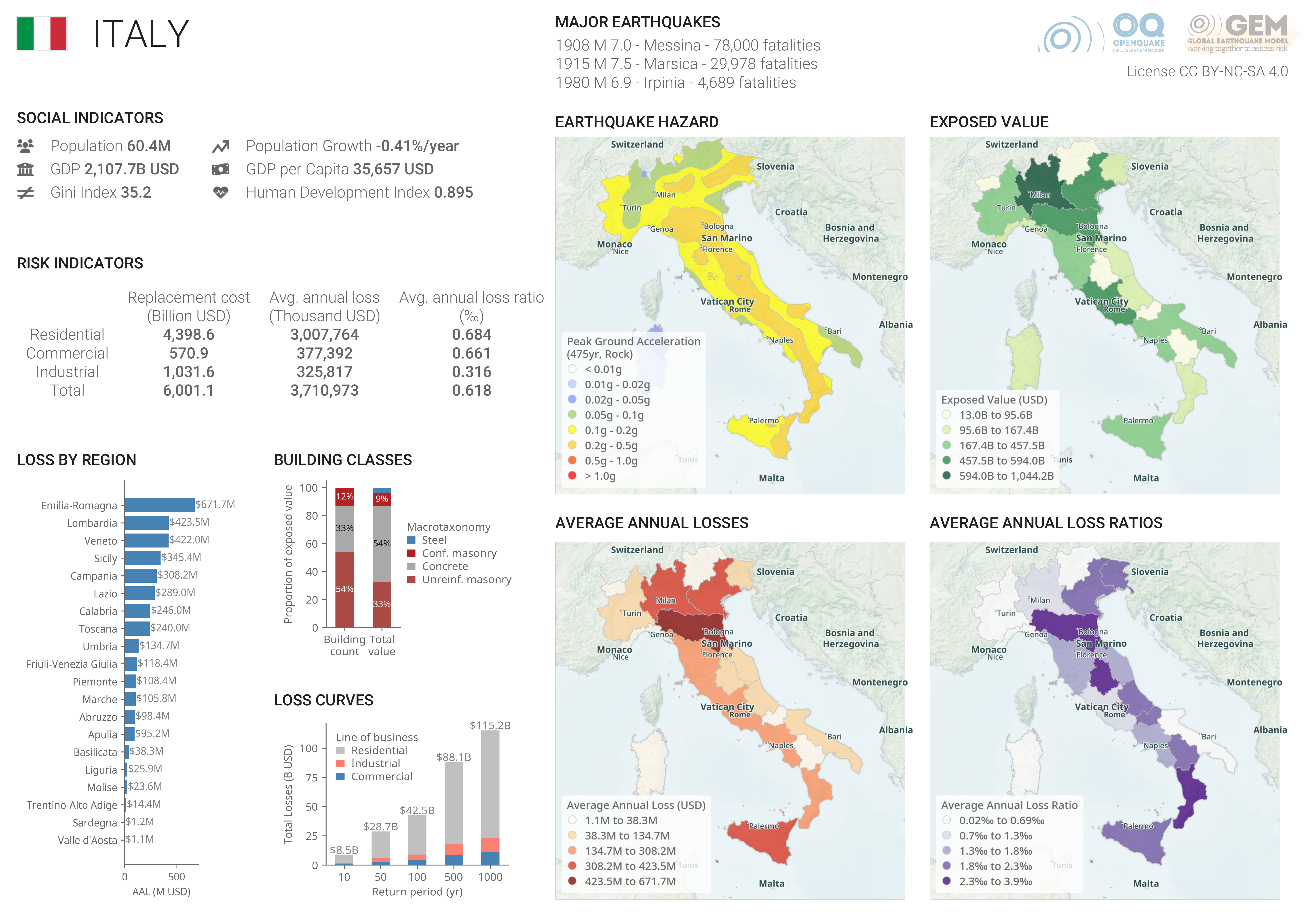
News Making Seismic Risk Information Open and Accessible: A Collaboration Between PreventionWeb and GEM Foundation By: Mar 27, 2024 Mar 20, 2024 Share Facebook LinkedIn March 20, 2024. A powerful new resource for understanding and mitigating earthquake risk at the national level is now available on the United Nations Office for Disaster Risk Reduction (UNDRR) PreventionWeb platform. This collaboration between UNDRR PreventionWeb and the Global Earthquake Model (GEM) Foundation makes over 200 country and territory seismic risk profiles accessible to a diverse global audience. These comprehensive profiles, developed by GEM , provide stakeholders in risk management with a vital overview of seismic risk in each country or territory. Each profile explores social and risk indicators, detailing factors like population density, building types, and historical earthquake impact. Additionally, loss curves depict potential losses based on different earthquake return periods, and maps visualise the geographical distribution of hazard, exposure, and potential losses. This collaboration marks a significant step forward in open access to critical disaster risk information. “Making this wealth of information readily available on PreventionWeb aligns perfectly with UNDRR’s mission to promote understanding and action on disaster risk reduction. By providing stakeholders with these insights, we can work together to better understand earthquake risk and build more resilient communities,” says Ms. Paola Albrito, Acting Special Representative of the Secretary-General for Disaster Risk Reduction and Director of UNDRR. “Open access to data and knowledge is fundamental for effective risk reduction strategies,” says Helen Crowley, GEM Secretary General. “This collaboration with UNDRR PreventionWeb ensures that our country and territory seismic risk profiles can reach the widest possible audience, informing decision-making, enhancing disaster preparedness and minimising earthquake losses.” Making these profiles available on a widely recognised platform like PreventionWeb, GEM and UNDRR enable stakeholders at various levels to make informed decisions about earthquake risk mitigation. This collaborative effort promotes a deeper understanding of seismic risk on a national scale, ultimately contributing to a safer future for communities around the world. To access the profiles, visit the following: PreventionWeb - https://www.preventionweb.net/knowledge-base/continents-countries GEM website - https://www.globalquakemodel.org/product/seismic-risk-profiles No images found. GALLERY 1/0 VIDEO RELATED CONTENTS FACT BOX
- GEM Provides Impact Estimates for Russia, Afghanistan, and Philippine Earthquakes - GEM Foundation
News GEM Provides Impact Estimates for Russia, Afghanistan, and Philippine Earthquakes By: Oct 6, 2025 Jul 29, 2025 Share Facebook LinkedIn As part of its role in the ARISTOTLE-ENHSP , the Global Earthquake Model (GEM) Foundation provided rapid impact analyses to the European Research Coordination Centre following three recent earthquakes: the magnitude 8.8 earthquake in Russia’s Kamchatka Peninsula on 29 July 2025, the magnitude 6.0 earthquake in Afghanistan’s Kunar and Nangarhar provinces on 31 August 2025, and the magnitude 6.9 earthquake in the Philippines’ Cebu province on 30 September 2025. Assessing the Kamchatka Earthquake The Kamchatka event was classified as a Red alert for economic losses by the USGS PAGER system, thus triggering GEM’s post-event protocol. GEM scientists used the global hazard and risk models in combination with USGS ShakeMap products to generate impact estimates. While the earthquake was very large, evidence suggested lower-than-expected ground shaking, underscoring the challenge of constrained data in remote regions. GEM’s analyses explored different assumptions for ground motion behaviour, providing ranges of possible impacts to inform ongoing evaluations. Supporting Decision-Making in Afghanistan The Afghan earthquake was also classified as a Red alert for fatalities by the USGS PAGER system. GEM used the epicentre from the European-Mediterranean Seismological Centre (EMSC), combined with a rupture generated using its Global EarthquakE ScEnarios (GEESE) algorithm and regional hazard models, to estimate the likely range of consequences. Outputs shared with the European Commission’s Joint Research Centre (JRC) supported satellite mapping operations. In one case, GEM’s estimates confirmed that the most affected areas had been correctly prioritised for imaging, despite damage being difficult to detect from satellite data. This provided responders with confidence in their initial assessments. Delivering Rapid Analysis in the Philippines For the 30 September earthquake in Cebu, GEM applied its oq-impact tool to generate impact estimates for fatalities, injuries, displaced population, economic losses, and building damage. Maps of expected building loss, fatalities, and homelessness were shared with the Philippine Institute of Volcanology and Seismology (PHIVOLCS) to complement national monitoring efforts. These analyses are based on the USGS rupture, GEM’s global ground motion models, and exposure and vulnerability models for the Philippines providing a first-order estimate of expected impacts while more detailed local data are being gathered. Bridging Science and Response Feedback from partners, including JRC, emphasised the value of GEM’s modelling in the immediate aftermath of earthquakes. By providing independent, model-based estimates, GEM helps humanitarian agencies and national authorities allocate resources more confidently, especially when on-the-ground information is scarce or satellite information is unreliable. Towards Greater Collaboration While GEM is not an operational emergency-response organisation, its role as an information provider helps humanitarian agencies, governments, and international partners respond more effectively to disasters. The recent events in Russia, Afghanistan and the Philippines highlight how scientific models can complement field data and satellite imagery in shaping rapid response. GEM continues to encourage open collaboration and data sharing with partners worldwide, recognising that bridging the gap between science and action is essential for strengthening earthquake resilience – and disaster resilience more broadly – across the globe. Contact us at info@globalquakemodel.org for inquiries or collaboration. No images found. GALLERY 1/0 VIDEO RELATED CONTENTS FACT BOX