Thanks for submitting!
You will be contacted as soon as possible


QUICK LINKS


PROFILES
PUBLICATIONS
EXPOSURE
VULNERABILTY
SOFTWARE
EQ MODELS
Search Results
1046 results found with an empty search
- ALBANIA HAZARD MODELLING | Global Earthquake Model Foundation
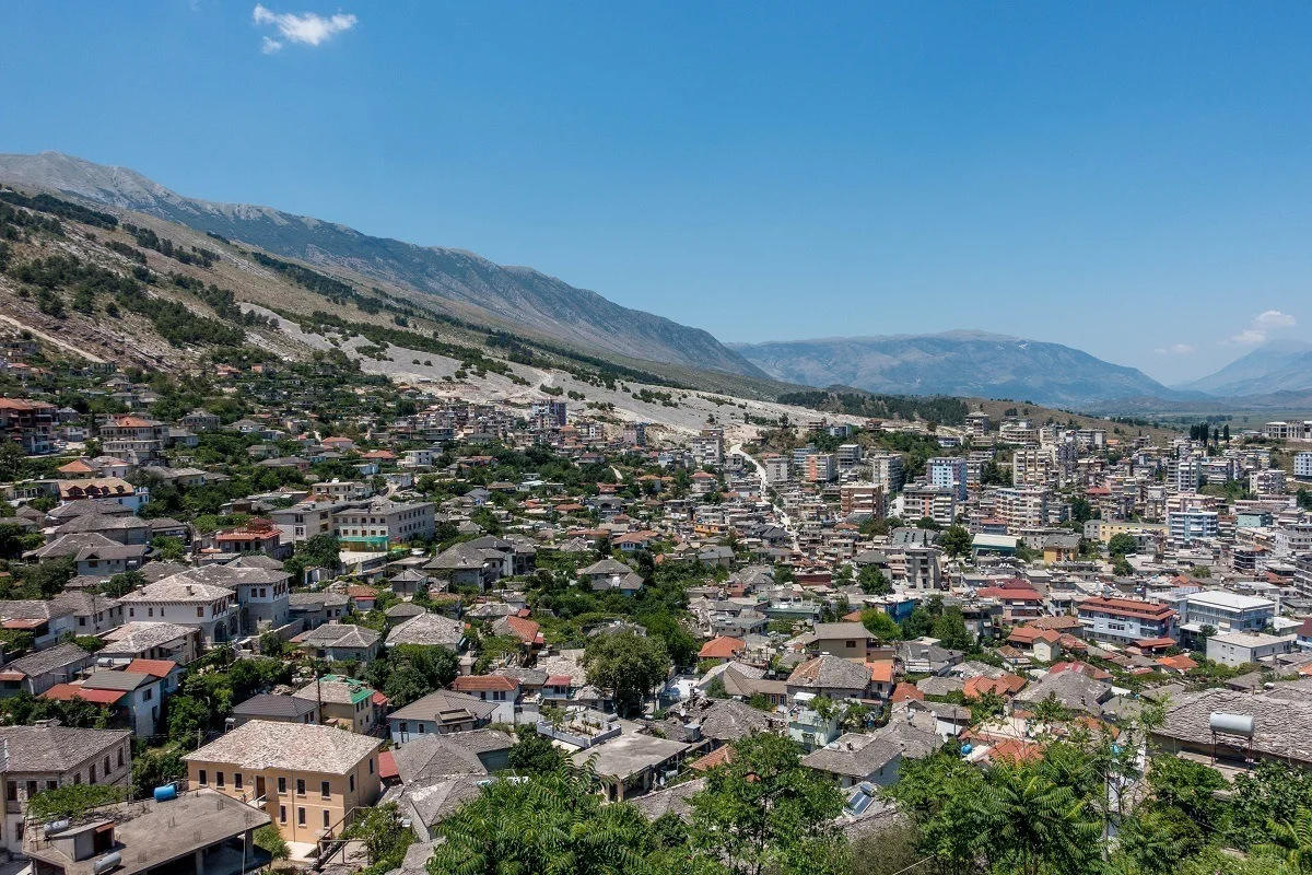
Projects ALBANIA HAZARD MODELLING Joint development of the Albanian seismic hazard model Versión en español English version Share Facebook LinkedIn Overview Outcomes Training Outreach Photos Publications Anchor 6 Background GEM and IGEO-Albania are currently implementing a 1-year project funded by the European Investment Fund and supported by the Electrical Corporation of Albania to update Albania’s probabilistic seismic hazard model through a series of technical workshops. The GEM Hazard Team is providing support on the use of its open source tools for hazard model building and assessment. Duration: 2023 Objectives The main objectives of this project are to update the national seismic hazard model for Albania, and provide the outputs that can be used in the National Annex of Eurocode 8, for the seismic design of buildings in Albania. Collaborators GEM Foundation, Institute of Geosciences (IGEO) Funding Partner: European Investment Fund, Electrical Corporation of Albania Location Albania Anchor 1 Anchor 5 Anchor 4 Strengthening Albania's Earthquake Preparedness: A Collaborative Effort This project, funded by the Central European Initiative and supported by the Albanian Electricity Corporation, has two objectives. It aims to modernize Albania's seismic hazard map, a crucial step in updating the nation's building code to meet Eurocode 8 standards. This marks the first significant revision to Albania's building regulations since 1989. A more updated view of seismic hazard will help in promoting more cost-effective earthquake-resistant construction practices. Read more Albania’s Institute of Geosciences (IGEO) and GEM collaborate to update the national seismic hazard model GEM and IGEO-Albania implemented a 1-year project funded by the Central European Initiative (CEI - https://www.cei.int/) and the Albanian Electricity Corporation (KESH - https://www.kesh.al/en/) to update Albania's probabilistic seismic hazard model through a series of technical workshops. Read more Anchor3 BUSINESS NEWS NSHMA 2024 Presentation, Tirana, Albania - July 16, 2024 Photo credits: IGEO 1/3 BUSINESS NEWS GEM - IGEO Albania Workshop, Pavia 2023 1/4 Publications
- READY2RESPOND | Global Earthquake Model Foundation
Projects READY2RESPOND Rapid Diagnostic in Uttarakhand and Himachal Pradesh Versión en español English version Share Facebook LinkedIn Overview Anchor 6 Background Ready2Respond (R2R) is a rapid diagnostic guide, designed to improve national, sub-national and city resilience mechanisms and to protect development gains through investments in emergency preparedness and response systems. It is informed by the World Bank Group (WBG) City Resilience Program (CRP) and other WBG resilience platforms. In this project R2R is applied to the Uttarakhand and Himachal Pradesh states in the Himalayan region of India. The GEM Risk Team contributes to the project by providing: Literature review and stakeholder mapping around hazard and risk initiatives, risk data and models for both states Provision of seismic hazard/risk model outputs and related descriptive information for both states (to support diagnostic activities) Review of legal regulation of the built environment and associated initiatives Review of seismic preparedness of the critical infrastructure defined in the project Preparation and remote input into stakeholder workshops Duration: 2023 Objectives This project responds to the need to provide effective and comprehensive diagnosis of the Uttarakhand and Himachal Pradesh states’ emergency preparedness and response systems in the Himalayan region of India. This enables the World Bank and the government to tailor investments to strengthen institutional capacity and capability, ensure public safety, and limit economic disruption in the face of multiple, and often cascading, geological and hydrometeorological hazards. Collaborators GEM Foundation, JBA Consulting, Geo Climate Risk Solutions (GCRS) Funding partner: World Bank Group Location India Himalayas Anchor 1 Anchor 5 Anchor 4 Anchor3 Publications
- CAREC | Global Earthquake Model Foundation
Projects CAREC Developing a Disaster Risk Transfer Facility in the Central Asia Regional Economic Cooperation Region Versión en español English version Share Facebook LinkedIn Overview Outreach Anchor 6 Background Willis Towers Watson, a GEM Advisor Sponsor is leading the consortium of organizations to implement the project, “Developing a Disaster Risk Transfer Facility in the Central Asia Regional Economic Cooperation Region” supported by the Asian Development Bank. The GEM Risk Team is responsible for the exposure and seismic vulnerability components of the project, with the Hazard Team providing support in the preparation of risk profiles for countries in the Central Asia Regional Economic Cooperation Region. Objectives The project has three main components: (i) development of disaster risk assessments and modeling in all CAREC countries; (ii) design of a regional pilot disaster risk transfer facility for at least three CAREC countries; and (iii) capacity building and awareness raising activities to sensitize key public and private stakeholders in all CAREC countries about the benefits of disaster risk reduction, risk retention and risk transfer solutions. Willis Towers Watson, a GEM Advisor Sponsor is leading the consortium of organizations that will implement the project. The Central Asia Regional Economic Cooperation, or CAREC Program is a partnership of 11 countries (Afghanistan, Azerbaijan, People's Republic of China, Georgia, Kazakhstan, Kyrgyz Republic, Mongolia, Pakistan, Tajikistan, Turkmenistan, and Uzbekistan), supported by 6 multilateral institutions, working together to promote development through cooperation, leading to accelerated growth and poverty reduction. Location Central Asia Anchor 1 Anchor 5 Anchor 4 About the CAREC program Read more GEM has started a new project with WTW supported by the Asian Development Bank Read more ADB project overview and data sheet Read more Anchor3 Publications
- RENOMIZE | Global Earthquake Model Foundation
Projects RENOMIZE Renovation with automation and optimization of processes and products Versión en español English version Share Facebook LinkedIn Overview Anchor 6 Background This EU-funded initiative, supported by CINEA - European Climate, Infrastructure and Environment Executive Agency as the granting authority, is set to transform the renovation process by introducing advanced solutions that streamline every stage - from design to end-of-life - achieving significant cost and time savings. RENOMIZE's innovations include decision support tools for site preparation and technology integration, optimized process planning, and automated systems for anchor and panel placement. These solutions will undergo rigorous testing and demonstrations in Switzerland, Spain, Estonia, France, and Belgium to ensure their effectiveness and promote widespread adoption. GEM will share and contribute knowledge on risk-informed approaches to integrate resilience into renovation practices. Duration: 2025 - 2028 More details: https://cordis.europa.eu/project/id/101192326 Objectives RENOMIZE presents well-selected innovations in the processes and products for the full renovation trajectory from ideation, over-delivery, maintenance and end-of-life. Building on an impressive experience in the field, the following innovations have been put forward: Decision support tools for optimisation of building site preparations, integration of balconies and overhangs, and for the integration and selection of HVAC and RES technology; Optimisation of the process planning using advancements to spatiotemporal planning; Development of an improved anchoring system and panel-panel connections, optimised for automized non-sequential mounting, de/re-mounting; Self-positioning system and end-effectors thereon to support autonomous anchor and panel placement; Phased optimisation of the factory automation for cost reduction and quality improvement. These innovations will lead to cost savings beyond the aimed 25% and considerable time savings. Elaborate testing for disruptive events is previewed in Switzerland and Spain, while 4 complementary demonstrations will be delivered in Estonia, Switzerland, France, and Belgium. Stakeholders are engaged from the project's onset, and wider uptake is actively integrated into RENOMIZE’s concept through certification, technical assistance and various capacity-building activities. Collaborators Coordination Joanneum Research, Austria Project partners BuildUP, Belgium Timbeco Woodhouse, Estonia Litobox, Belgium Besix, Belgium Bomecon, The Netherlands Institut für nachhaltige Technologien AEE, Austria Tecnalia, Spain VITO (Vlaams Instituut voor Technologisch Onderzoek), Belgium Fondazione GEM, Italy Think E, Belgium Communauté d’Agglomération de Lens Liévin, France Funding partner: CINEA - European Climate, Infrastructure and Environment Executive Agency (HORIZON-CL5-2024-D4-01-01) Locations Austria Anchor 1 Anchor 5 Anchor 4 Anchor3 Publications
- CRAVE | Global Earthquake Model Foundation
Projects CRAVE Collaborative Risk Assessment for Volcanoes and Earthquakes (CRAVE) Versión en español English version Share Facebook LinkedIn Overview Outcomes Training Outreach Photos Publications Anchor 6 Summary The need to better understand the existing earthquake and volcano risk led to the establishment of the Global Earthquake Model (GEM) and the Global Volcano Model (GVM) network. GEM, founded in Italy in 2009, has been developing open tools and models to calculate and communicate seismic hazard and risk worldwide. Similarly, the GVM network represents an international community aiming to provide systematic evidence, data and analysis of volcanic hazards and risk on national, regional and global scales working with monitoring institutions to implement the best science and DRR strategies. Both GEM and the GVM network are currently leading international efforts that aim to mitigate the adverse effects from these perils. South America and ASEAN regions have been the target of numerous studies in the last two decades. However, most of these studies only focused on one component of the risk problem (e.g. hazard, vulnerability). Such limitation prevents the development of a comprehensive risk profile to properly inform decision-makers. The CRAVE project, through the current GEM and GVM network tools will offer a timely and unique opportunity to advance the understanding of seismic and volcanic risk in the region. Objectives This project aims to develop a common framework for the assessment of the impact from earthquakes and volcanoes, with an application in three countries located around the Pacific Rim. The activities comprised in this project feature several events to bring together global partners with the mandate to calculate and communicate seismic and volcanic risk, as well as training events to increase the capacity of local institutions in the assessment of their hazard and risk. Collaborators This project includes several partners including the following: British Geological Survey; the Earth Observatory of Singapore (EOS); the University of Edinburgh; the Volcano Disaster Assistance Program (VDAP) of the United States Geological Survey (USGS); and key organizations from the region including: the Colombian Geological Survey; the Philippine Institute of Volcanology and Seismology;(PHIVOLCS); and Badan Geologi (Indonesia). Location Colombia, Indonesia and the Philippines Volcano Scenario tool for OpenQuake The CRAVE project required the implementation of a new calculator in the OpenQuake Engine called ‘multi_risk’, which is able to manage at the same time different types of hazards, specifically ash fall, pyroclastic density currents flow, lava flow and lahar flow, passed as CSV files with headers ‘lon’, ‘lat’, ‘intensity’. The calculator is also able to consider the difference between dry and wet ash by setting the `ash_wet_amplification_factor` parameter in the job.ini file. The output of the calculator is a CSV file with ‘Exposure + Risk’ fields. For convenience we also produced a ‘Total Risk’ output which is simply the sum over the assets of the values in the ‘Exposure + Risk’ output. In order to support other formats used in the volcanic hazard community we prepared tools to convert hazard footprints into the format accepted by the OpenQuake-engine. These tools were included in the Input Preparation Toolkit. [Software ] Volcano Model example Full example of the volcano model developed with the Servicio Geológico Colombiano (SGC). [Data ] OpenQuake Volcano Risk Assessment OpenQuake for volcano risk assessment? Yes! Now you can perform volcanic scenarios. Checkout our tutorial! [Video ] Anchor 1 Anchor 5 Introduction The presentation of the tools and datasets from CRAVE took place in Bogota (Colombia) and Bandung (Indonesia). These events were organized by the Colombian Geological Survey and the Institute of Technology of Bandung. Kick-off Meeting The kick-off meeting took place in Bogota at the offices of the Colombian Geological Survey (SGC) on the 22nd of February 2018. During the meeting the goals of the CRAVE project were presented by GEM, as well as some concepts on seismic hazard, vulnerability and risk modelling. The British Geological Survey (BGS) presented general aspects of volcano hazard modelling and the mission of the Global Volcano Model, the SGC demonstrated how three volcanoes are currently being monitored and how seismic hazard maps have been developed in the past and the Rabaul Volcano Observatory (RVO) presented the current situation in terms of volcano hazard monitoring and assessment in Papua New Guinea. During this event all partners also discussed the way forward, including the division of tasks, case studies, relevant risk outputs and the timeframe for the next workshops. Bandung, Indonesia (20-22 of May) Workshop – IT Bandung With support from the Institute of Technology of Bandung (ITB), the event featured a day of presentations and discussion with representatives from the Center for Volcanology and Geological Hazard Mitigation (CVGHM), the Indonesian Ministry of Public Works, the National Disaster Management Agency (Badan Nasional Penanggulangan Bencana - BNPB), the Meteorology, Climatology and Geophysics Agency (Badan Meteorologi, Klimatologi dan Geofisika - BMKG), the Philippine Institute of Volcanology and Seismology (PHIVOLCS) and the British Geological Survey (BGS). Bogota, Colombia (13-17 of May) Workshop - Geological Survey of Colombia Five days in Bogota provided a fruitful time to share and discuss the national volcanic hazard and risk assessment, as well as risk management challenges in the country. The workshop was divided into two main parts: The first part focused on the technical aspects of volcanic hazard and risk assessment. Representatives from the three mains national volcanological observatories participated in the sessions (Manizales, Popayan and Pasto). The second part of the workshop was conceived for a broader audience, involving stakeholders that contribute to the Disaster Risk Reduction strategy in the country. Anchor 4 CRAVE project kicks off in Colombia The USAID project – Collaborative Risk Assessment for Volcanoes and Earthquakes or CRAVE successfully kicked off with a workshop in Bogota, Colombia. [News ] CRAVE in Colombia and Indonesia Members of the USAID-supported project – CRAVE from Colombia and Indonesia participated in two separate workshops to discuss volcanic threats and risks. [News ] CRAVE workshop, Bandung, Indonesia Workshop at IT Bandung exploring open tools and models for #earthquake and #volcano #hazard and #risk assessment with project partners. [Social Media ] Anchor3 BUSINESS NEWS CRAVE project workshops held in Bogota, Colombia 1/3 BUSINESS NEWS CRAVE project workshops held in Bandung, Indonesia 1/5 Publications CRAVE Project Final Report Final Report to USAID/OFDA for: CRAVE-Collaborative Risk Assessment for Volcanoes and Earthquakes [Report ] Disclaimer The contents of this project website such as studies, reports, audio-visual, news articles, blogs, and other information or media products including those in the external links are made possible by the generous support of the American people through the United States Agency for International Development (USAID). The contents are the responsibility of the Global Earthquake Model (GEM) Foundation and do not necessarily reflect the views of USAID or the United States Government.
- FORCE | Global Earthquake Model Foundation
Projects FORCE Forecasting and Communicating Earthquake Hazard and Risk (FORCE) Versión en español English version Share Facebook LinkedIn Profile Outcomes Training Schedule Outreach Photos Publications Anchor 6 Overview This project, supported by USAID Bureau for Humanitarian Assistance (BHA), aims to enhance earthquake hazard modeling capabilities in small communities, as well as to provide better risk models to account for changes in the number of occupants, structures and economic value exposed to earthquakes and the adverse effects of climate change. The project will evaluate future earthquake risk losses, thus supporting decision makers with risk metrics that account for the expected evolution of the built environment, which are fundamental for the design and implementation of long-term risk reduction measures. Objectives The project aims to strengthen the capacities and understanding to manage and respond to future earthquake risk by: introducing future growth or change into national and global exposure models to enable the quantification of future disaster losses, including those associated with climate change; developing communication and dissemination tools to maximize the uptake of disaster risk information in policy making bodies; and improving the reliability of earthquake hazard and risk assessment, in particular in regions that lack information. To achieve the above, the project will implement five components below: Predicting the evolution of the built environment and population Forecasting future disaster risk due to earthquakes Incorporating infrastructure in exposure modeling for risk assessment Modeling earthquake hazard and risk for small communities Advancing communication and dissemination of risk information Collaborators Funding partner: USAID Bureau for Humanitarian Assistance (BHA) El Salvador: Science partner: University of El Salvador (contact Manual Menjivar, associate Professor). Government partner: Ministerio de Medio Ambiente y Recursos Naturales, MARN (contacts Douglas Antonio Hernández, Geology Area Coordinator, and Luis Mixco, seismologist). Nepal: Science partner: National Society for Earthquake Technology, NSET (contact Surya Narayan Shrestha, Executive Director). Government partner: National Disaster Risk Reduction and Management Authority (NDRRMA). Bhutan: Science partner: College of Science and Technology-Royal University of Bhutan (contact Chimi Wangmo, Head of Department, Civil Engineering DepartmentCheki Dorji). Pacific partners: Secretariat of Pacific Community (SPC), Geoscience, Energy and Maritime Division (contact Litea Biukoto, Geohazards Risk Management Leader) Indian Ocean partner: The Indian Ocean Commission IOC, (contact Gina Bonne, Director) Government partners: Member states and territories of the SPC and IOC through their representatives. Additionally, collaboration is expected from GEM partners Geoscience Australia (GA) and Geological and Nuclear Sciences (GNS), New Zealand, considering their active role in the region. Location Bhutan, El Salvador, Nepal, and small communities in oceans Seismic Risk Forecasting for a Safer El Salvador The FORCE project assesses El Salvador’s seismic risk today and projects future impacts over the next 30 years under two scenarios: continuing current construction practices or fully adopting modern seismic codes. The findings highlight the urgent need for stronger building regulations to reduce economic and human losses. View summary of results | Download 1. Historical Earthquakes and Their Destructive Potential El Salvador has experienced numerous significant earthquakes, each shaping the country’s approach to disaster preparedness. This dashboard provides a comprehensive analysis of historical seismic events, highlighting their destructive potential and reinforcing the need for proactive risk management to reduce future impacts. Eventos_históricos_potencial_destructivo_Dashboard_Luis_Mixco_PPT View details | Download 2. Seismic Codes and Future Risk Scenarios What role do building regulations play in disaster risk reduction? This study examines the impact of seismic codes on El Salvador’s future risk landscape. By comparing scenarios with and without strengthened regulations, the findings emphasize how improved construction practices can significantly reduce losses and enhance community resilience. Codigo-Riesgo_Futuro View details | Download 3. Forecasting Seismic Risk in El Salvador How will seismic risk evolve in the next 30 years? This risk forecast presents two possible futures - one where risk remains high due to unregulated construction and another where proactive policies and seismic codes reduce vulnerabilities. The results underscore the importance of long-term planning for disaster resilience. Pronostico_Riesgo View details | Download Anchor 1 Anchor 5 Online and Onsite Training Workshops This part of the program is designed to improve the understanding and awareness of earthquake hazards and risks and to help bridge the gap between the information produced in the project sites and its communication to a wide variety of stakeholders through online and onsite training workshops. Under the FORCE project, Spring and Autumn OpenQuake training courses will be offered. Please check back regularly for the latest training activities. Modules covered by the OpenQuake Online Training Courses The online training Modules 2-4, discuss how to explore and prepare the required input files for earthquake scenarios, PSHA (such as hazard maps for different return periods, hazard curves, and uniform hazard spectra), and event-based risk analysis in the OpenQuake-engine, how to run an example and visualise the results. Module 1 OQ Introduction is a self-learning module available at training.openquake.org . OpenQuake Online Training Language: Spanish Upcoming session dates Module II (part 1) February 6, 2024 Module II (part 2) February 20, 2024 Module III February 13, 2024 Module IV February 27, 2024 ----- OpenQuake Training: an online course for beginners Language: English Completed session dates March 20, 2023 March 27, 2023 April 17, 2023 April 24, 2023 ----- Anchor 4 Advancing communication and dissemination of risk information The activities in this component are focused on raising awareness of the public on earthquake hazard and risk by training a diverse group of disaster risk reduction (DRR) professionals together with personnel in charge of communicating risk to the public, and by conducting community-based workshops in the pilot countries. Luis Mixco and GEM’s Cata Yepes Featured on El Salvador’s National News El Salvador’s Ministry of Environment has launched a new tool designed to quickly estimate earthquake damage, enabling a faster response to affected communities. Watch as Luis Mixco, Ministry of Environment and Natural Resources of El Salvador, and GEM’s Cata Yepes discuss this important development in a national news segment. https://youtu.be/MfGn347363c?si=WrpbeeVkjsVFrnZ3 Strengthening Pacific Resilience: Highlights from the Workshop GEM concluded a successful two-day training workshop in Suva, Fiji, as part of the FORCE project. Held on November 18-19, the workshop focused on understanding earthquake hazard and risk in the Southwest Pacific - a region highly vulnerable to seismic activity. Facilitated by GEM’s Catalina Yepes Estrada, Exposure Development Lead, and Kendra Johnson, Senior Seismic Hazard Scientist, the training brought together local stakeholders and experts to explore practical approaches to earthquake risk assessment and disaster preparedness. Participants engaged in hands-on exercises using GEM’s OpenQuake engine, explored probabilistic seismic hazard and risk analysis, and discussed ways to improve resilience through better data and modeling. A key takeaway was the importance of tailoring risk models to local needs, with opportunities for participants to share insights on addressing data and resource challenges unique to the Pacific region. The workshop was held alongside the STAR Conference, where GEM also presented on leveraging hazard and risk models for sustainable development and disaster risk reduction. A big thank you to all participants for their active engagement and to our partners - the Mineral Resources Department (MRD) in Fiji, the Pacific Community (SPC), UNESCO, and the USAID Bureau for Humanitarian Assistance, GEM's funding partner for the FORCE project - for their collaboration in making this event possible. These shared efforts are crucial as we work toward a safer and more resilient future for communities in the Pacific. Read more PSHA for the Oceans Webinar In this webinar, we explored the key features of the Global Seismic Hazard Mosaic and the PAC model, with a special focus on the ocean models in the Southwest Pacific. We presented GEM’s approach to building PSHA models that span vast regions, even in data-scarce areas. Additionally, we highlighted seismic hazard trends across the region, including insights for key population centers. The recording and presentation are now available and can be accessed here: https://www.globalquakemodel.org/gemevents/psha-oceans-force-project Read more FORCE project: Groundwork activities gain strong support from local and national stakeholders in Nepal GEM’s USAID-supported Forecasting and Communicating Earthquake Hazard and Risk (FORCE) project kicked off in Kathmandu, Nepal from February 20th to 24th by meeting local and national partners involved in disaster risk reduction activities in the country. A half-day introductory workshop for key project stakeholders on February 24th capped the groundwork activities. (report with detailed information ) Read more Strengthening Bhutan's Resilience: GEM's Collaborative Efforts in Seismic Risk Reduction Thimphu, Bhutan - March 15, 2024. The Global Earthquake Model (GEM) Foundation's USAID-supported project, Forecasting and Communicating Earthquake Hazard and Risk (FORCE), recently concluded a successful week of activities in Bhutan (March 11-15, 2024). Led by GEM's Alejandro Calderon and Catarina Costa, the project focuses on strengthening local capacities and improving earthquake risk reduction in the country (report with detailed information ). Read more A Resilient Future: Embracing Innovation and Leveraging Local Expertise and Collaboration to Enhance Seismic Risk Reduction in El Salvador The Global Earthquake Model (GEM) Foundation's USAID-supported project, Forecasting and Communicating Earthquake Hazard and Risk (FORCE), has been working to help strengthen local capacities and improve earthquake risk reduction in El Salvador. The project has conducted two visits to the country, bringing together government agencies, scientists, engineers, and other stakeholders to discuss seismic hazard assessment, risk analysis, and communication strategies (report with detailed information ). Read more - English | Spanish FORCE Project Update: Predicting Urban Growth and Population Evolution One critical component of this project involves predicting urban growth and population evolution. This involves analysing more than 20 potential drivers of urban development over several decades. These encompass factors such as demographic trends, economic metrics, and land-use patterns. The FORCE team is actively developing urban growth models utilising techniques like regression analysis and machine learning. Currently, these models are undergoing meticulous evaluation to ensure their ability to replicate observed increases in dwelling numbers and construction areas. Read more Earthquakes in El Salvador: What Do We Know and How Could They Affect Us in the Coming Years? GEM's FORCE project made notable developments in #ElSalvador last week. Various meetings and technical activities were conducted highlighted by a workshop that convened stakeholders to discuss the topic "#Earthquakes in El Salvador: What Do We Know and How Could They Affect Us in the Coming Years?" In collaboration with the USAID - Bureau for Humanitarian Assistance (USAID/BHA), and national partners Ministerio de Medio Ambiente y Recursos Naturales de El Salvador (MARN) and Dirección General de Protección Civil de El Salvador, this session marked a crucial step in advancing #seismic #risk #understanding and response capabilities. Thanks to all for the productive discussions and active participation! FORCE Project Updates: City Zonation workshops Our sessions with USAID focused on city zonation for #emergencyresponse in #Medellin, followed by a workshop communicating #seismic #risk to first responders in our ongoing collaboration with Universidad EAFIT, #SIATA - Sistema de Alerta Temprana del Valle de Aburrá, and #AMVA - Área Metropolitana del Valle de Aburrá. These initiatives are fundamental in enhancing emergency preparedness efforts. #EmergencyPreparedness #SeismicRiskCommunication SATIC Event, OpenQuake Conference, Cali Risk Assessment and Community Awareness Workshops An event was held at the Banco de la República Auditorium in Cali, Colombia from November 21-25 to present seismic scenarios for Cali using Cali risk models; introduction of OpenQuake Tools; and training workshop for the use of the information repository and risk models, including awareness workshops for the community (local trainers, firefighters, civil defense). Read more Workshop on Probabilistic Seismic Hazard Assessment (PSHA), Risk Analysis, and the OpenQuakeEngine at FEPADE in El Salvador The Ministry of Environment and Natural Resources (MARN) of #ElSalvador and the GEM Foundation successfully concluded a workshop on Probabilistic Seismic Hazard Assessment (#PSHA), #Risk #Analysis, and the #OpenQuakeEngine at FEPADE in El Salvador, as part of the USAID - Bureau for Humanitarian Assistance-supported #FORCE #Project. This workshop substantially contributes to building local expertise in this crucial pilot project area, reinforcing El Salvador's #earthquake #resilience. We extend heartfelt thanks to our dedicated #local #partners for their invaluable contributions, pivotal in ensuring the success of this event! Read more Online session on seismic hazard and risk assessment in the Pacific Our FORCE project team successfully concluded an online session on seismic hazard and risk assessment in the #Pacific. With participation from 15 attendees representing 7 countries, the session explored Session 1 - Seismic #hazard and #risk information available in the Global Mosaic. Attendees were informed of various #earthquake #hazard and #risk outputs within the GEM Foundation, such as hazard maps, hazard curves, uniform hazard spectra, #exposure models, #vulnerability and #fragility models, and risk metrics. Discussions also focused on what information is included in GEM’s Country Seismic Risk Profiles. These insights underscored the significance of #seismic #assessment in the region. Stay tuned for updates on future sessions! #FORCEProject #SeismicAssessment #GEMFoundation New GEM-USAID Project Forecasting and Communicating Earthquake Hazard and Risk (FORCE) launched On the heels of the successful completion of the TREQ project partnership this year, GEM and USAID Bureau for Humanitarian Assistance (BHA) are embarking on a new project called Forecasting and Communicating Earthquake Hazard and Risk or FORCE. The project aims to strengthen the capacities and understanding to manage and respond to future earthquake risk. Read more Anchor3 BUSINESS NEWS Workshop summarising the USAID-supported initiative in El Salvador led by GEM’s local partners, January 21-24, 2025 The activities focused on sharing and communicating the project's outcomes, including updated earthquake hazard and risk models, impact metrics, and capacity-building activities. GEM's Alejandro Calderon and Catalina Yepes-Estrada joined as participants to share insights on project outcomes, tools, and lessons learned with stakeholders. 1/4 BUSINESS NEWS Strengthening Pacific Resilience: Highlights from the Workshop - November 18-19, 2024, Suva, Fiji GEM concluded a successful two-day training workshop in Suva, Fiji, as part of the FORCE project. Held on November 18-19, the workshop focused on understanding earthquake hazard and risk in the Southwest Pacific - a region highly vulnerable to seismic activity. 1/2 BUSINESS NEWS Activities in Bhutan (March 11-15, 2024) A series of technical meetings and workshops on the FORCE project in Bhutan was held from the 11th to the 15th of March 2024. 1/3 BUSINESS NEWS El Salvador Stakeholder Workshop January 11, 2024 Earthquakes in El Salvador: What Do We Know and How Could They Affect Us in the Coming Years? 1/8 BUSINESS NEWS El Salvador Meetings January 9, 2024 Meetings with the Protección Civil de El Salvador. 1/3 BUSINESS NEWS Medellin Workshops December 2023 with AMVA Workshops on city zonation for #emergencyresponse in #Medellin , followed by a workshop communicating #seismic #risk to first responders in our ongoing collaboration with Universidad EAFIT , #SIATA - Sistema de Alerta Temprana del valle de Aburrá, and #AMVA - Área Metropolitana del Valle de Aburrá. 1/2 BUSINESS NEWS El Salvador November 2023 Workshop Introduction to Probabilistic Seismic Hazard (PSHA) and Risk Analysis and the OpenQuake Engine with MARN hosted by the Fundación Empresarial para el Desarrollo Educativo (FEPADE) November 6-10, 2023. 1/5 BUSINESS NEWS SATIC event in Cali, Colombia Nov 21-25, 2022 1/6 BUSINESS NEWS Kick-off meetings in Nepal The launch meetings of the FORCE project – Forecasting and Communicating Earthquake Hazard and Risk were held in the city of Kathmandu, Nepal, from 20th to 24th February 2023. 1/11 Publications Similar to the TREQ project, reports and publications relevant to each of the FORCE project components will be produced and published in due course. This page is dedicated to this purpose. Forecasting and Communicating Earthquake Risk - Bhutan Technical Visits in Bhutan A series of technical meetings and workshops of the FORCE project – Forecasting and Communication Earthquake Risk – were held in Bhutan from the 11th to the 15th of March 2024. One-to-one meetings were organised with the main governmental departments involved in Disaster Risk Reduction activities in the country, along with a workshop held in Thimphu on 12th March 2024, that included an important group of stakeholders. Moreover, a presentation to students and college staff from the Royal University of Bhutan in Phuentsholing was held on the 14th of March 2024. Representatives of the GEM Foundation and the College of Science and Technology (CST) from the Royal University of Bhutan (RUB) attended all meetings and were the coordinators of the visit activities in the country. Pronostico y Comunicacion de Riesgos por Terremotos Visitas técnicas en El Salvador EL proyecto FORCE: Pronóstico y comunicación de la amenaza y el riesgo de terremotos (Forecasting and Communicating Earthquake Hazard and Risk por sus siglas en inglés), realizó dos visitas a El Salvador con el objetivo de fortalecer las capacidades locales y la comunicación de los resultados de riesgo sísmico a las diferentes entidades que forman parte de la prevención, gestión y respuesta ante terremotos destructivos en el país. De la mano del Ministerio de Medio Ambiente y Recursos Naturales (MARN) se realizaron talleres y reuniones con diferentes actores del sector público como Protección Civil, Ministerio de Obras Públicas, Fondo de Conservación Vial de El Salvador, Cuerpo de Bomberos, Ministerio de Educación, Instituto Salvadoreño del Seguro Social, Oficina de Planificación del Área Metropolitana de San Salvador (OPAMSS), entre otros. Kick-off meetings in Nepal FORCE Project The launch meetings of the FORCE project – Forecasting and Communication Earthquake Risk were held in Kathmandu, Nepal, from 20th to 24th February 2023. Multiple one-to-one meetings were held with the main governmental departments involved in Disaster Risk Reduction activities, and a workshop with an important group of stakeholders was held on 24th February 2023. Representatives of the GEM Foundation and NSET attended all meetings and will be the coordinators of the project activities in the country. Disclaimer The contents of this project website such as studies, reports, audio-visual, news articles, blogs, and other information or media products including those in the external links are made possible by the generous support of the American people through the United States Agency for International Development (USAID). The contents are the responsibility of the Global Earthquake Model (GEM) Foundation and do not necessarily reflect the views of USAID or the United States Government.
- Proyecto TREQ | Global Earthquake Model Foundation
Projects Proyecto TREQ Comunicación y Formación en la Evaluación de Riesgos por Terremotos (TREQ) Versión en español English version Share Facebook LinkedIn Visión general Resultados Capacitación Comunicación Fotos Publicaciones Anchor 6 Resumen El Proyecto de Capacitación y Comunicación para la Evaluación de Riesgos de Terremotos (TREQ) fue diseñado para demostrar cómo la evaluación de la amenaza y el riesgo sísmico puede informar a los tomadores de decisiones en el desarrollo de políticas de reducción de riesgos, así como también cómo se puede comunicar adecuadamente el riesgo de terremotos a las partes interesadas y al público en general. [PDF Executive Summary English ] Objetivos El proyecto se organizó en dos partes principales. El primero tuvo como objetivo desarrollar la capacidad para la evaluación de la amenaza y el riesgo sísmico a nivel urbano en América Latina, Quito (Ecuador), Cali (Colombia) y Santiago de los Caballeros (República Dominicana); mientras que la segunda parte fue desarrollar material de capacitación, educación y comunicación para mejorar la comprensión del riesgo de terremotos en todo el mundo. El programa se diseñó para un amplio espectro de partes interesadas, categorizadas en cuatro grupos principales: gobierno(tomadores de decisiones/autoridades públicas), industria (practicantes y profesionales), academia (investigadores y profesores) y la comunidad. Ecuador Municipalidad de Quito Escuela Politécnica Nacional (EPN) Instituto Geofísico (IG) Colegio de Ingenieros Civiles de Pichincha (CICP) Pontificia Universidad Católica del Ecuador Dominican Republic Servicio Geológico Nacional (SGN) Oficina Nacional de Evaluación Sísmica y Vulnerabilidad de Infraestructuras y Edificaciones (ONESVIE) Comité Técnico Nacional (CTN) Pontificia Universidad Católica Madre y Maestra (PUCMM) Colombia Servicio Geológico Colombiano (SGC) Departamento Administrativo de Planeación Municipal (DAPM), Cali Unidad Nacional de Gestión del Riesgo de Desastres (UNGRD) Universidad EAFIT, Medellin Costa Rica Universidad de Costa Rica (UCR) Mexico Universidad Autónoma de Baja California (UABC) Ubicación Quito (Ecuador), Cali (Colombia) y Santiago de los Caballeros (República Dominicana) Evaluación del riesgo urbano en América Latina y el Caribe En este componente se generaron los siguientes entregables: evaluación de amenaza y riesgo sísmico a escala urbana para las tres ciudades TREQ: Quito (Ecuador), Cali (Colombia) y Santiago de los Caballeros (República Dominicana). Se desarrollaron modelos de vanguardia para cada ciudad en estrecha colaboración con socios locales. Los modelos de entrada y los resultados están disponibles en la siguiente dirección URL: [github.com/gem/treq-riesgo-urbano/ ] a. Informes de la ciudad Evaluación de Riesgo Sísmico para el Distrito Metropolitano de Quito [Español ] Evaluación de Riesgo Sísmico para Santiago de Cali [Español ] Evaluación de Riesgo Sísmico para Santiago de los Caballeros [Español ] b. Evaluación de peligros sísmicos Modelos probabilísticos de amenaza sísmica (PSHA) y conjuntos de datos para la evaluación de la amenaza a nivel urbano [PDF English ] Modelo Probabilístico de Amenaza Sísmica para la República Dominicana [PDF English | Español ] [Descargar Modelo ] Resultados de amenaza sísmica (condiciones en roca y en suelo [PDF English ] Análisis de la amenaza sísmica a escala urbana [PDF English ] c. Evaluación de Riesgo Sísmico Resumen ejecutivo sobre la evaluación del riesgo sísmico urbano para las ciudades de Quito, Cali y Santiago de los Caballeros [PDF English ] Tipologías constructivas en Quito, Cali and Santiago de los Caballeros [PDF Español ] Base de datos de exposición georreferenciada de población y edificios en cada ciudad de TREQ [Cali ] [Quito ] [Santiago ] Base de datos de funciones de fragilidad y vulnerabilidad para cada clase de edificio presente en el modelo de exposición [Datos ] Mapas y métricas de riesgo para cada ciudad [Cali ] [Quito ] [Santiago ] d. Escenarios de la ciudad Base de datos con rupturas seleccionadas para análisis de escenarios [Cali ] [Quito ] [Santiago ] Evaluación del escenarios de amenaza para sismos representativos en Quito, Cali y Santiago de los Caballeros [PDF English ] e. Aplicaciones Urbanas Deslizamientos y licuefacción inducidos por sismo en Cali [PDF English ] Anchor 1 Anchor 5 Mejora de la comprensión mundial sobre la amenaza y riesgo sísmico Esta parte del programa fue diseñada para mejorar la comprensión y el conocimiento de la amenaza y el riesgo sísmico, y para ayudar a cerrar la brecha entre la información producida en estudios detallados de amenaza y riesgo y su comunicación a una amplia variedad de partes interesadas (que van desde locales expertos con competencias para evaluar el riesgo sísmico, a los tomadores de decisiones responsables de la implementación de medidas de reducción del riesgo). a. Sitio web para la capacitación en línea de OpenQuake La capacitación en línea de OpenQuake se diseñó para diferentes tipos de audiencia con diversos antecedentes y experiencia. A través de esta plataforma, los participantes interactuaron con los equipos científicos y técnicos del GEM para conocer los principales conceptos de la evaluación del riesgo sísmico, así como las características básicas del software de OpenQuake. [English | Español ] b. Manual de OpenQuake en formato online El manual oficial se convirtió de látex al formato reStructuredText gracias al apoyo de @USAID. El nuevo manual está ahora en línea en formato HTML y se puede accederse en: [Webpage English ] c. Tutoriales en video sobre peligros sísmicos y análisis de riesgos usando OpenQuake El proyecto ha producido 15 videos de capacitación técnica utilizando el software de OpenQuake (en inglés y español), 7 videos con material para difundir los modelos y resultados de la evaluación del riesgo urbano en las ciudades TREQ y 2 videos para comunicar el riesgo sísmico al público en general. público. OQ Engine Video Tutorials [ English | Español ] d. Manual para realizar análisis de amenaza sísmica Este manual presenta los conceptos básicos de la metodología clásica de PSHA y el amplio espectro de alternativas para modelar la sismicidad y las incertidumbres (epistémicas y aleatorias) en el software de OpenQuake. La evaluación probabilística del peligro sísmico (PSHA) es la metodología principal para evaluar el peligro potencial que representan los terremotos. Los mapas de amenaza se utilizan ampliamente en los códigos sísmicos nacionales para la zonificación de la amenaza sísmica y las disposiciones de diseño estructural. [PDF English ] e. Capacitando a educadores TREQ ha colaborado con cinco profesores universitarios de América Latina para conceptualizar, crear e implementar un curso unificado para el estudio del riesgo sísmico a nivel universitario. Los folletos en inglés y español explican con más detalle el concepto detrás de esta iniciativa y describen los primeros resultados y experiencias de los profesores de Colombia, Costa Rica, El Salvador, Guatemala y México. [PDF English | Español ] Anchor 4 Comunicación y sensibilización sobre terremotos Las actividades de este componente se centraron en sensibilizar al público sobre la amenaza y el riesgo sísmico mediante la capacitación de un grupo diverso de profesionales en reducción del riesgo de desastres (RRD), junto con el personal a cargo de comunicar los riesgos al público, y mediante la realización de talleres comunitarios en áreas seleccionadas de las ciudades piloto. Artículos de noticias Eventos El seminario web Comprensión del riesgo sísmico a través del desarrollo de capacidades y el intercambio de conocimientos atrae a cientos de participantes de todo el mundo. [Article ] [Event page English | Español ] [Video ] Presentación del modelo PSHA nacional para la República Dominicana: un seminario web conjunto organizado por el Servicio Geológico Nacional Dominicano en cooperación con GEM, Oficina Nacional de Evaluación Sísmica y Vulnerabilidad de Infraestructura y la Oficina de Asistencia Humanitaria de USAID. [Event flyer Español ] [Video English | Español ] ---- Artículos Raising Earthquake Risk Awareness: TREQ’s community workshops for the general public Urban hazard assessment of selected cities in Latin America Local solutions to global problems: reducing disaster risk through collaboration and openness TREQ Project Updates: Site Effects Modelling and Urban Exposure Models USGS has joined the TREQ initiative for urban earthquake scenarios TREQ capacity building: OQ online training updates Jan-Feb 2021 TREQ2020 – Capacity development and OpenQuake online training, year in review TREQ OpenQuake Online Training: Earthquake Scenarios - Ground Motion Fields Sept 2020 Más en la sección GEM News a. Material didáctico para sensibilizar a la comunidad sobre el riesgo sísmico: Aplicación para el área Metropolitana del Valle de Aburrá (AMVA) [PDF Español ] b. Video para comunicar el riesgo de terremoto al público en general [English | Español ] c. Guía para profesores para el desarrollo de un curso introductorio de riesgo sísmico [PDF Español ] d. Perfiles de respuesta y mitigación de riesgos urbanos para las ciudades TREQ [Cali ] [Quito ] [Santiago ] Boletin informativo El boletín del proyecto TREQ tiene la intención de compartir actividades en evaluación de riesgos urbanos y materiales de capacitación y educación sobre riesgos de terremotos con una amplia gama de partes interesadas locales de la academia, los sectores público y privado, así como la sociedad civil en América Latina,el Caribe, y más allá. Newsletter no. 3 - May 2021 Newsletter no. 2 - September 2020 Newsletter no. 1 - March 2020 Maiden issue [English ] Maiden issue [Españo ] Anchor3 BUSINESS NEWS Concientizando el Riesgo: talleres para el público en general 1/4 BUSINESS NEWS Inicio del proyecto de marzo de 2020 1/4 BUSINESS NEWS Fotos de la formación OpenQuake Online de noviembre de 2020 1/2 BUSINESS NEWS Reuniones en Quito 1/10 BUSINESS NEWS Reuniones en Guayaquil 1/1 Publications Visión general TREQ Resumen Ejecutivo [English ] Evaluación de la amenaza sísmica Modelos probabilísticos de amenaza sísmica (PSHA) y conjuntos de datos para la evaluación de la amenaza a nivel urbano [English ] Modelo Probabilístico de Amenaza Sísmica para la República Dominicana [English | Español ] [Descargar Modelo ] Resultados de amenaza sísmica (condiciones en roca y en suelo [English ] Análisis de la amenaza sísmica a escala urbana [English ] Evaluación de Riesgo Sísmico Resumen ejecutivo sobre la evaluación del riesgo sísmico urbano para las ciudades de Quito, Cali y Santiago de los Caballeros [English ] Tipologías constructivas en Quito, Cali and Santiago de los Caballeros [Español ] Escenarios sísmicos Evaluación del escenarios de amenaza para sismos representativos en Quito, Cali y Santiago de los Caballeros [English ] Aplicaciones urbanas Deslizamientos y licuefacción inducidos por sismo en Cali [English ] Informes de la ciudad Evaluación de Riesgo Sísmico para el Distrito Metropolitano de Quito [Español ] Evaluación de Riesgo Sísmico para Santiago de Cali [Español ] Evaluación de Riesgo Sísmico para Santiago de los Caballeros [Español ] Formación y comunicación del riesgo sísmico Manual de capacitación sobre análisis probabilístico de riesgos sísmicos (PSHA) [English ] Material didáctico para sensibilizar a la comunidad sobre el riesgo sísmico. Aplicación para el área Metropolitana del Valle de Aburrá (AMVA) [Español ] Guía para profesores para el desarrollo de un curso introductorio de riesgo sísmico [Español ] Disclaimer The contents of this project website such as studies, reports, audio-visual, news articles, blogs, and other information or media products including those in the external links are made possible by the generous support of the American people through the United States Agency for International Development (USAID). The contents are the responsibility of the Global Earthquake Model (GEM) Foundation and do not necessarily reflect the views of USAID or the United States Government.
- BEYOND BUTTON PUSHING | Global Earthquake Model Foundation
Projects BEYOND BUTTON PUSHING Earthquake Risk Assessment and Sensitivity Analysis for California Versión en español English version Share Facebook LinkedIn Overview Anchor 6 Background The goal of the project was to show how important the quantification of uncertainty is in estimating and understanding California’s earthquake risk using OpenQuake - GEM Foundation’s state-of-the-art open source earthquake hazard and risk assessment software. With OpenQuake’s plug-and-play capabilities, expert users can individually select or substitute every model component, data, and assumption. This feature will help model users and decision makers to: 1) ‘ask the right questions’ when evaluating model results; 2) better interpret risk assessment results and gain trust in model results; and 3) make better risk management decisions. Duration: 2015-2017 Objectives The main objectives of this project are to: Establish representative sets of exposure: ‣ for the San Francisco Bay Area; ‣ for the Southern California region affected by the Shakeout Scenario Choose specific results (risk metrics) to use as a basis for comparison. Produce ‘baseline’ results from OpenQuake, using a ‘control’ set of assumptions. Undertake a thorough sensitivity analysis for the risk estimates for California based on the UCERF3 model by running OpenQuake multiple times, each time varying one assumption or parameter, such as: ‣ earthquake probabilities (controlled by assumptions about fault geometries, slip rates, maximum magnitudes); ‣ ground motion model selection; ‣ vulnerability functions; ‣ site conditions; and ‣ statistical treatment of uncertainty and correlation Beyond the aims stated at the outset of the project as listed above, several additional objectives were achieved during the course of the project, including the following: Implement within OpenQuake the latest seismic hazard model for California based on the recently published Uniform California Earthquake Rupture Forecast version 3 (UCERF3), produced by the U.S. Geological Survey and the Working Group on California Earthquake Probabilities. Calculate the average annual loss estimates for all 8,057 census tracts in California, using the seismic hazard model based on UCERF3. Establish the range (distribution) of scientifically viable results for the chosen risk metrics by accounting for the various uncertainties in the hazard model. Identify the components of the hazard model contributing most to the overall uncertainty in the risk metrics for the different exposure portfolios. Implement a model simplification (‘logic-tree trimming’) software tool to reduce the number of computer runs and greatly speed up the time required for running the risk model for California. Collaborators GEM Foundation Funding partner: Alfred E. Alquist Seismic Safety Commission (SSC) Location California, United States Anchor 1 Anchor 5 Anchor 4 Anchor3 Publications
- WESTERN BALKANS CCDR | Global Earthquake Model Foundation
Projects WESTERN BALKANS CCDR Input to World Banks' Country Climate and Development Report (CCDR) for Western Balkans Versión en español English version Share Facebook LinkedIn Overview Anchor 6 Background As part of the World Bank Groups' Country Climate and Development Reports (CCDRs), the GEM Foundation and JBA Risk Management are working together to provide current (2021) and future (2050) earthquake and flood risk assessment for 6 West Balkans countries: Albania, Bosnia and Herzegovina, Kosovo, Montenegro, North Macedonia and Serbia. The GEM Risk Team is providing the exposure database (property and population data) for both the flood and seismic risk assessment for six Western Balkan countries at the lowest administrative level, using both existing datasets for 2021 and socio-economic projections for forecasted exposure to 2050. Seismic hazard and risk assessment for the current and future exposure is also being undertaken with the OpenQuake engine, leading to average annual losses and losses for specific return periods for each country. Duration: 2023 Objectives The World Bank is preparing the Country Climate and Development Report for the Western Balkans. The CCDR aims to inform policy dialogue and engagement with governments. This provides an opportunity to carry out several analytical pieces, including in the area of Disaster Risk Management, bringing together existing knowledge on the economic and social impacts of disasters and climate change, and delivering new analytical insights to support policy recommendations. Collaborators JBA Risk Management, GEM Foundation Funding partner: World Bank Group Locations Albania, Bosnia and Herzegovina, Kosovo, Montenegro, North Macedonia and Serbia. Anchor 1 Anchor 5 Anchor 4 Anchor3 Publications
- HORUS | Global Earthquake Model Foundation
Projects HORUS Horus: Pilot for a generic damage evaluation methodology based on remote-sensing data Versión en español English version Share Facebook LinkedIn Overview Anchor 6 Background Horus is a pilot project that explores the combination of high-resolution building inventory data from OpenStreetMap and other local sources with image-processing algorithms for the detection of earthquake damage and flood extents using remote-sensing data, along with supplementary geospatial datasets as inputs to a machine learning (ML) classification model. The ML model is trained using detailed building damage datasets from past events in a supervised learning framework, and the trained model is intended to be used to estimate the extent of damage and loss in events previously unseen by the model. The proposed framework is applied in three case study applications: March 2020 Mw5.3 Zagreb earthquake; January 2020 Mw6.4 Puerto Rico earthquake and August 2016 Louisiana floods. The GEM Risk Team is responsible for the overall coordination of the project involving multiple partners, compilation of building-level earthquake damage datasets, development of the ML models, and training and testing of the models. Duration: 2020 Objectives This pilot project, initiated and funded by the World Bank, aims to develop a framework for semi-automated damage and loss assessment due to earthquake and floods from Earth Observation (EO) data and other supplementary datasets, while also leveraging recent advances in machine-learning algorithms. These damage and loss estimates can potentially be used for transparent financial compensation and to target the distribution of resources geographically and temporally. Collaborators Advanced Rapid Imaging and Analysis (ARIA) team at the National Aeronautics and Space Administration’s (NASA) Jet Propulsion Laboratory (JPL) and California Institute of Technology (Caltech), the Global Earthquake Model (GEM) Foundation, JBA Risk, and the Humanitarian OpenStreetMap Team (HOT) Funding partner: World Bank Group Locations Earthquake case studies: Gorkha, Nepal; Puebla, Mexico; Puerto Rico, United States; Zagreb, Croatia Flood case study: Louisiana, United States Anchor 1 Anchor 5 Anchor 4 Anchor3 Publications