Thanks for submitting!
You will be contacted as soon as possible


QUICK LINKS


PROFILES
PUBLICATIONS
EXPOSURE
VULNERABILTY
SOFTWARE
EQ MODELS
Search Results
1074 results found with an empty search
- Global Earthquake Model Foundation | Italy
Global Earthquake Model Foundation: For a world that is resilient to earthquakes through earthquake hazard and risk assessment. Global Earthquake Model foundation Global Earthquake Model foundation For a world that is resilient to earthquakes and other natural hazards. For a world that is resilient to earthquakes and other natural hazards. presents presents GEM CONFERENCE 2026 GEM CONFERENCE 2026 From Faults to Future Scenarios From Faults to Future Scenarios FIND OUT MORE Global Earthquake Model foundation For a world that is resilient to earthquakes and other natural hazards. Latest RED ALERT Earthquake: 31st August 2025 M6.0 Afghanistan More Details What We Do Our purpose is to develop, together with the global community, scientific resources for transparent earthquake hazard and risk assessment, and to facilitate their application for risk management. PROVIDE Global standards for earthquake hazard and risk modelling. SUPPORT Partner with communities for disaster risk reduction STRENGTHEN Build capacity, especially in the Global South Latest Updates Conference GEM2026 Conference: Register by 28 February 2026! More Product ATLAS Online Ordering Now Available! More Workshop Mapping Exposure, Advancing Resilience: GEM’s One-Day Workshop More Available Seismic Hazard and Risk Models and Datasets By selecting a region in the global map below, a table will appear to quickly take you to the available resources in that region. You can also use the Search box to look up any specific region, country or territory. Popup title Close Country/Region North and South Korea Hazard Exposure Vulnerability Risk Profile Conterminous US Hazard Exposure Vulnerability Risk Profile Northwest Asia Hazard Exposure Vulnerability Risk Profile Northeast Asia Hazard Exposure Vulnerability Risk Profile Pacific Islands Hazard Exposure Vulnerability Risk Profile Hawaii Hazard Exposure Vulnerability Risk Profile Arabia Hazard Exposure Vulnerability Risk Profile Alaska Hazard Exposure Vulnerability Risk Profile Sub-Saharan Africa Hazard Exposure Vulnerability Risk Profile West Africa Hazard Exposure Vulnerability Risk Profile North Africa Hazard Exposure Vulnerability Risk Profile Tuvalu Hazard Exposure Vulnerability Risk Profile Uganda Hazard Exposure Vulnerability Risk Profile Ukraine Hazard Exposure Vulnerability Risk Profile United Arab Emirates Hazard Exposure Vulnerability Risk Profile United Kingdom Hazard Exposure Vulnerability Risk Profile United States of America Hazard Exposure Vulnerability Risk Profile Uruguay Hazard Exposure Vulnerability Risk Profile US Virgin Islands Hazard Exposure Vulnerability Risk Profile Uzbekistan Hazard Exposure Vulnerability Risk Profile Vanuatu Hazard Exposure Vulnerability Risk Profile Venezuela Hazard Exposure Vulnerability Risk Profile Vietnam Hazard Exposure Vulnerability Risk Profile Yemen Hazard Exposure Vulnerability Risk Profile Zambia Hazard Exposure Vulnerability Risk Profile Zimbabwe Hazard Exposure Vulnerability Risk Profile Africa Hazard Exposure Vulnerability Risk Profile Caribbean Central America Hazard Exposure Vulnerability Risk Profile Central Asia Hazard Exposure Vulnerability Risk Profile East Asia Hazard Exposure Vulnerability Risk Profile Europe Hazard Exposure Vulnerability Risk Profile Middle East Hazard Exposure Vulnerability Risk Profile North America Hazard Exposure Vulnerability Risk Profile North Asia Hazard Exposure Vulnerability Risk Profile Oceania Hazard Exposure Vulnerability Risk Profile South America Hazard Exposure Vulnerability Risk Profile South Asia Hazard Exposure Vulnerability Risk Profile Southeast Asia Hazard Exposure Vulnerability Risk Profile Palestine Hazard Exposure Vulnerability Risk Profile Panama Hazard Exposure Vulnerability Risk Profile Papua New Guinea Hazard Exposure Vulnerability Risk Profile Paraguay Hazard Exposure Vulnerability Risk Profile Peru Hazard Exposure Vulnerability Risk Profile Philippines Hazard Exposure Vulnerability Risk Profile Poland Hazard Exposure Vulnerability Risk Profile Portugal Hazard Exposure Vulnerability Risk Profile Puerto Rico Hazard Exposure Vulnerability Risk Profile Qatar Hazard Exposure Vulnerability Risk Profile Romania Hazard Exposure Vulnerability Risk Profile Russia Hazard Exposure Vulnerability Risk Profile Rwanda Hazard Exposure Vulnerability Risk Profile Saint Kitts and Nevis Hazard Exposure Vulnerability Risk Profile Saint Lucia Hazard Exposure Vulnerability Risk Profile Saint Vincent and the Grenadines Hazard Exposure Vulnerability Risk Profile Samoa Hazard Exposure Vulnerability Risk Profile Sao Tome and Principe Hazard Exposure Vulnerability Risk Profile Saudi Arabia Hazard Exposure Vulnerability Risk Profile Senegal Hazard Exposure Vulnerability Risk Profile Serbia Hazard Exposure Vulnerability Risk Profile Seychelles Hazard Exposure Vulnerability Risk Profile Sierra Leone Hazard Exposure Vulnerability Risk Profile Singapore Hazard Exposure Vulnerability Risk Profile Slovakia Hazard Exposure Vulnerability Risk Profile Slovenia Hazard Exposure Vulnerability Risk Profile Solomon Islands Hazard Exposure Vulnerability Risk Profile Somalia Hazard Exposure Vulnerability Risk Profile South Africa Hazard Exposure Vulnerability Risk Profile South Korea Hazard Exposure Vulnerability Risk Profile South Sudan Hazard Exposure Vulnerability Risk Profile Spain Hazard Exposure Vulnerability Risk Profile Sri Lanka Hazard Exposure Vulnerability Risk Profile Sudan Hazard Exposure Vulnerability Risk Profile Suriname Hazard Exposure Vulnerability Risk Profile Sweden Hazard Exposure Vulnerability Risk Profile Switzerland Hazard Exposure Vulnerability Risk Profile Syria Hazard Exposure Vulnerability Risk Profile Taiwan Hazard Exposure Vulnerability Risk Profile Tajikistan Hazard Exposure Vulnerability Risk Profile Tanzania Hazard Exposure Vulnerability Risk Profile Thailand Hazard Exposure Vulnerability Risk Profile Timor Leste Hazard Exposure Vulnerability Risk Profile Togo Hazard Exposure Vulnerability Risk Profile Tonga Hazard Exposure Vulnerability Risk Profile Trinidad and Tobago Hazard Exposure Vulnerability Risk Profile Tunisia Hazard Exposure Vulnerability Risk Profile Turkey Hazard Exposure Vulnerability Risk Profile Turkmenistan Hazard Exposure Vulnerability Risk Profile Turks and Caicos Islands Hazard Exposure Vulnerability Risk Profile Kiribati Hazard Exposure Vulnerability Risk Profile Kosovo Hazard Exposure Vulnerability Risk Profile Kuwait Hazard Exposure Vulnerability Risk Profile Kyrgyzstan Hazard Exposure Vulnerability Risk Profile Laos Hazard Exposure Vulnerability Risk Profile Latvia Hazard Exposure Vulnerability Risk Profile Lebanon Hazard Exposure Vulnerability Risk Profile Lesotho Hazard Exposure Vulnerability Risk Profile Liberia Hazard Exposure Vulnerability Risk Profile Libya Hazard Exposure Vulnerability Risk Profile Liechtenstein Hazard Exposure Vulnerability Risk Profile Lithuania Hazard Exposure Vulnerability Risk Profile Luxembourg Hazard Exposure Vulnerability Risk Profile Macao Hazard Exposure Vulnerability Risk Profile Madagascar Hazard Exposure Vulnerability Risk Profile Malawi Hazard Exposure Vulnerability Risk Profile Malaysia Hazard Exposure Vulnerability Risk Profile Mali Hazard Exposure Vulnerability Risk Profile Malta Hazard Exposure Vulnerability Risk Profile Marshall Islands Hazard Exposure Vulnerability Risk Profile Martinique Hazard Exposure Vulnerability Risk Profile Mauritania Hazard Exposure Vulnerability Risk Profile Mauritius Hazard Exposure Vulnerability Risk Profile Mexico Hazard Exposure Vulnerability Risk Profile Micronesia Hazard Exposure Vulnerability Risk Profile Moldova Hazard Exposure Vulnerability Risk Profile Monaco Hazard Exposure Vulnerability Risk Profile Mongolia Hazard Exposure Vulnerability Risk Profile Montenegro Hazard Exposure Vulnerability Risk Profile Montserrat Hazard Exposure Vulnerability Risk Profile Morocco Hazard Exposure Vulnerability Risk Profile Mozambique Hazard Exposure Vulnerability Risk Profile Myanmar Hazard Exposure Vulnerability Risk Profile Namibia Hazard Exposure Vulnerability Risk Profile Nauru Hazard Exposure Vulnerability Risk Profile Nepal Hazard Exposure Vulnerability Risk Profile Netherlands Hazard Exposure Vulnerability Risk Profile New Caledonia Hazard Exposure Vulnerability Risk Profile New Zealand Hazard Exposure Vulnerability Risk Profile Nicaragua Hazard Exposure Vulnerability Risk Profile Niger Hazard Exposure Vulnerability Risk Profile Nigeria Hazard Exposure Vulnerability Risk Profile Niue Hazard Exposure Vulnerability Risk Profile North Korea Hazard Exposure Vulnerability Risk Profile North Macedonia Hazard Exposure Vulnerability Risk Profile Northern Mariana Islands Hazard Exposure Vulnerability Risk Profile Norway Hazard Exposure Vulnerability Risk Profile Oman Hazard Exposure Vulnerability Risk Profile Pakistan Hazard Exposure Vulnerability Risk Profile Palau Hazard Exposure Vulnerability Risk Profile Democratic Republic of the Congo Hazard Exposure Vulnerability Risk Profile Denmark Hazard Exposure Vulnerability Risk Profile Djibouti Hazard Exposure Vulnerability Risk Profile Dominica Hazard Exposure Vulnerability Risk Profile Dominican Republic Hazard Exposure Vulnerability Risk Profile Ecuador Hazard Exposure Vulnerability Risk Profile Egypt Hazard Exposure Vulnerability Risk Profile El Salvador Hazard Exposure Vulnerability Risk Profile Equatorial Guinea Hazard Exposure Vulnerability Risk Profile Eritrea Hazard Exposure Vulnerability Risk Profile Estonia Hazard Exposure Vulnerability Risk Profile Eswatini Hazard Exposure Vulnerability Risk Profile Ethiopia Hazard Exposure Vulnerability Risk Profile Fiji Hazard Exposure Vulnerability Risk Profile Finland Hazard Exposure Vulnerability Risk Profile France Hazard Exposure Vulnerability Risk Profile French Guiana Hazard Exposure Vulnerability Risk Profile Gabon Hazard Exposure Vulnerability Risk Profile Gambia Hazard Exposure Vulnerability Risk Profile Georgia Hazard Exposure Vulnerability Risk Profile Germany Hazard Exposure Vulnerability Risk Profile Ghana Hazard Exposure Vulnerability Risk Profile Gibraltar Hazard Exposure Vulnerability Risk Profile Greece Hazard Exposure Vulnerability Risk Profile Grenada Hazard Exposure Vulnerability Risk Profile Guadeloupe Hazard Exposure Vulnerability Risk Profile Guam Hazard Exposure Vulnerability Risk Profile Guatemala Hazard Exposure Vulnerability Risk Profile Guinea Hazard Exposure Vulnerability Risk Profile Guinea Bissau Hazard Exposure Vulnerability Risk Profile Guyana Hazard Exposure Vulnerability Risk Profile Haiti Hazard Exposure Vulnerability Risk Profile Honduras Hazard Exposure Vulnerability Risk Profile Hong Kong Hazard Exposure Vulnerability Risk Profile Hungary Hazard Exposure Vulnerability Risk Profile Iceland Hazard Exposure Vulnerability Risk Profile India Hazard Exposure Vulnerability Risk Profile Indonesia Hazard Exposure Vulnerability Risk Profile Iran Hazard Exposure Vulnerability Risk Profile Iraq Hazard Exposure Vulnerability Risk Profile Ireland Hazard Exposure Vulnerability Risk Profile Isle of Man Hazard Exposure Vulnerability Risk Profile Israel Hazard Exposure Vulnerability Risk Profile Italy Hazard Exposure Vulnerability Risk Profile Ivory Coast Hazard Exposure Vulnerability Risk Profile Jamaica Hazard Exposure Vulnerability Risk Profile Japan Hazard Exposure Vulnerability Risk Profile Jordan Hazard Exposure Vulnerability Risk Profile Kazakhstan Hazard Exposure Vulnerability Risk Profile Kenya Hazard Exposure Vulnerability Risk Profile Afghanistan Hazard Exposure Vulnerability Risk Profile Albania Hazard Exposure Vulnerability Risk Profile Algeria Hazard Exposure Vulnerability Risk Profile American Samoa Hazard Exposure Vulnerability Risk Profile Andorra Hazard Exposure Vulnerability Risk Profile Angola Hazard Exposure Vulnerability Risk Profile Anguilla Hazard Exposure Vulnerability Risk Profile Antigua and Barbuda Hazard Exposure Vulnerability Risk Profile Argentina Hazard Exposure Vulnerability Risk Profile Armenia Hazard Exposure Vulnerability Risk Profile Aruba Hazard Exposure Vulnerability Risk Profile Australia Hazard Exposure Vulnerability Risk Profile More Products Downloadable Resources OpenQuake OpenQuake Engine Risk Profiles Country-Territory Seismic Risk Profiles Risk Global Seismic Risk Map Exposure Global Exposure Map Hazard Global Seismic Hazard Map Vulnerability Global Vulnerability Model Collaborative Projects Close Completed Location Ongoing More Projects
- Collaborative Projects | Global Earthquake Model Foundation | Italy
Hazard and risk assessment projects with regional, national and local collaborators covering more than 150 countries in Europe, Middle East, South America, Central America, North America, Sub-Saharan Africa, Asia and the Pacific. PROJECTS GEM’s collaborative network comprises more than 100 public and private institutions, which has led to GEM’s participation in more than 50 regional, national, and multilateral projects covering Europe, Middle East, South America, Central America, North America, Sub-Saharan Africa, Asia and the Pacific. Share Facebook LinkedIn Anchor 1 Key Projects - 2013 and beyond Sort by Order by 1 2 3 4 5 1 ... 1 2 3 4 5 6 7 8 9 ... 9 0 Filters: 46 results found View: Map List Gallery Seismic impact scenarios for Istanbul Status: Completed The project aims to provide information on the cost per square meter (USD) for reconstruction and various retrofitting options, and provide seismic impact scenarios for the Istanbul metropolitan area, with disaggregated information on building types, building age, and spatial areas. View CAREC Phase II: Developing a Disaster and Climate Risk Transfer Facility in the Central Asia Regional Economic Cooperation Region Status: Ongoing This project builds upon the modelling and analytical work conducted under TA-9878 (https://www.globalquakemodel.org/proj/carec) . It involves the preparation and implementation of a pilot disaster relief bond (DRB) that will be issued by the Asian Development Bank (ADB) for two countries, namely, the Kyrgyz Republic and Tajikistan. View SeismIc hazard and Ground Motion Assessment Status: Ongoing The SIGMA program is a Research and Development project about seismic hazard and ground motion. View Piattaforma Analisi Pericolosità E Rischio Sismico Status: Ongoing The Global Earthquake Model (GEM) Foundation has launched the PAPERS project (Piattaforma Analisi Pericolosità E Rischio Sismico), an initiative aimed at developing a new WebGIS platform for scenario hazard and risk assessment in Italy. The project has been funded as one of the cascade grants launched by the High-Performance Computing, Big Data e Quantum Computing Research Centre, one of the five National Centres established by the Italian National Recovery and Resilience Plan (NRRP), under Spoke 5 - Environment and Natural Disasters . View COMET-GEM Central Asia Seismic Hazard Project Status: Completed The COMET-GEM collaboration aims to develop an advanced, publicly accessible seismic hazard and risk model for Central Asia, integrating cutting-edge scientific methods such as satellite geodesy, palaeoseismology, and geodetic data analysis. View Title Location Status Seismic impact scenarios for Istanbul Completed CAREC Phase II: Developing a Disaster and Climate Risk Transfer Facility in the Central Asia Regional Economic Cooperation Region Central Asia Ongoing SeismIc hazard and Ground Motion Assessment Ongoing Piattaforma Analisi Pericolosità E Rischio Sismico Pilot Site for Seismic Risk Analysis: An Italian city to be determined during the project, intended as a demonstration case for urban-scale seismic risk analysis. Testing Locations: The project will involve data collection and analysis on a national scale across Italy. Ongoing COMET-GEM Central Asia Seismic Hazard Project Primary Focus Region: Central Asia Additional Areas of Study: South Caucasus, Türkiye, Mongolia Completed WFP-ADAM+ Innovation Accelerator Project Earthquake-prone WFP Countries with initial pilots in Afghanistan, Nepal, Turkey, Syria, Haiti, and the Philippines. Completed Renovation with automation and optimization of processes and products Austria Ongoing North-Eastern Atlantic and Mediterranean Tsunami Risk Management and Planning Southern Europe Ongoing European Plate Observing System-Optimisation and EvolutioN (EPOS ON) Project Europe Ongoing ASCE Earthquake Loads Overseas (AELO) Global (Washington DC, USA) Ongoing Page 1 of 5 1 2 3 4 5 1 ... 1 2 3 4 5 6 7 8 9 ... 9 Completed Ongoing Washington DC Close Completed Location Ongoing
- RENOMIZE | Global Earthquake Model Foundation
Projects RENOMIZE Renovation with automation and optimization of processes and products Versión en español English version Share Facebook LinkedIn Overview Anchor 6 Background This EU-funded initiative, supported by CINEA - European Climate, Infrastructure and Environment Executive Agency as the granting authority, is set to transform the renovation process by introducing advanced solutions that streamline every stage - from design to end-of-life - achieving significant cost and time savings. RENOMIZE's innovations include decision support tools for site preparation and technology integration, optimized process planning, and automated systems for anchor and panel placement. These solutions will undergo rigorous testing and demonstrations in Switzerland, Spain, Estonia, France, and Belgium to ensure their effectiveness and promote widespread adoption. GEM will share and contribute knowledge on risk-informed approaches to integrate resilience into renovation practices. Duration: 2025 - 2028 More details: https://cordis.europa.eu/project/id/101192326 Objectives RENOMIZE presents well-selected innovations in the processes and products for the full renovation trajectory from ideation, over-delivery, maintenance and end-of-life. Building on an impressive experience in the field, the following innovations have been put forward: Decision support tools for optimisation of building site preparations, integration of balconies and overhangs, and for the integration and selection of HVAC and RES technology; Optimisation of the process planning using advancements to spatiotemporal planning; Development of an improved anchoring system and panel-panel connections, optimised for automized non-sequential mounting, de/re-mounting; Self-positioning system and end-effectors thereon to support autonomous anchor and panel placement; Phased optimisation of the factory automation for cost reduction and quality improvement. These innovations will lead to cost savings beyond the aimed 25% and considerable time savings. Elaborate testing for disruptive events is previewed in Switzerland and Spain, while 4 complementary demonstrations will be delivered in Estonia, Switzerland, France, and Belgium. Stakeholders are engaged from the project's onset, and wider uptake is actively integrated into RENOMIZE’s concept through certification, technical assistance and various capacity-building activities. Collaborators Coordination Joanneum Research, Austria Project partners BuildUP, Belgium Timbeco Woodhouse, Estonia Litobox, Belgium Besix, Belgium Bomecon, The Netherlands Institut für nachhaltige Technologien AEE, Austria Tecnalia, Spain VITO (Vlaams Instituut voor Technologisch Onderzoek), Belgium Fondazione GEM, Italy Think E, Belgium Communauté d’Agglomération de Lens Liévin, France Funding partner: CINEA - European Climate, Infrastructure and Environment Executive Agency (HORIZON-CL5-2024-D4-01-01) Locations Austria Anchor 1 Anchor 5 Anchor 4 Anchor3 Publications
- PERU PUBLIC SCHOOLS | Global Earthquake Model Foundation
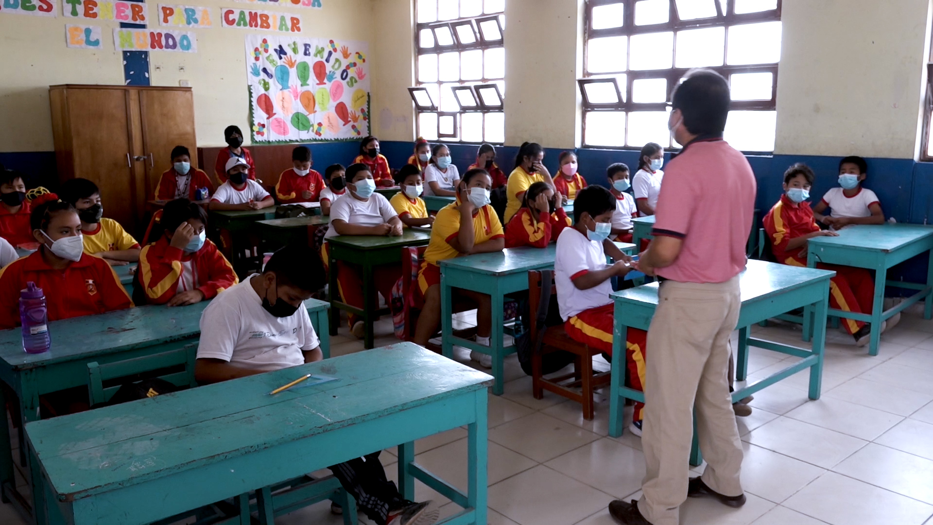
Projects PERU PUBLIC SCHOOLS Development of an Insurance Program for Peru’s Public Schools Versión en español English version Share Facebook LinkedIn Overview Anchor 6 Background The project aims to protect more than 50,000 public schools in Peru against the impact of natural hazards, and to improve continuity for children’s education by accelerating reconstruction and strengthening the country’s resilience through an innovative insurance programme. The GEM Hazard and Risk Teams are contributing to the design of the insurance programme with expertise in the earthquake hazard and risk modelling of school buildings in Peru. For more information, visit https://www.bmz.de/en/issues/climate-change-and-development/climate-risk-insurance/59532-59532. Duration: 2020 - 2024 Objectives The main objective of this project is to design an insurance programme for Peru’s public schools. The project will provide the Government of Peru with options to cover all or a subset of its more than 50,000 public schools against the impact of natural hazards thus accelerating reconstruction, while also strengthening the country’s resilience. Collaborators GEM Foundation, AXA XL, Munich Re, Peruvian Association of Insurance Companies (APESEG), JBA Risk Management, InsurTech Picsure. Funding partner: Germany’s InsuResilience Solutions Fund (ISF) Location Peru Anchor 1 Anchor 5 Anchor 4 Anchor3 Publications
- WB-Istanbul | Global Earthquake Model Foundation
Projects WB-Istanbul Seismic impact scenarios for Istanbul Versión en español English version Share Facebook LinkedIn Overview Anchor 6 Background Türkiye is situated in a seismically active region, with a history of significant earthquakes that have led to substantial loss of life, economic disruption, and damage to infrastructure. The country's rapid urbanization and the presence of numerous buildings constructed before the introduction of modern building codes contribute to its vulnerability to seismic events. Istanbul, Türkiye’s largest city, is of particular concern due to its high population density, economic significance, and the potential impact of a major earthquake. The city has a mix of old and new structures, with many residential buildings constructed before the year 2000, when the country's modern building codes were introduced. These older structures are often not designed to withstand significant seismic forces, making them particularly susceptible to damage or collapse in the event of an earthquake. Given this context, there is a critical need to understand the costs associated with retrofitting and reconstructing buildings to meet current seismic safety standards. The World Bank was interested in preparing accurate unit cost estimations for both reconstruction and retrofitting scenarios. Such estimations are essential for planning, budgeting, and implementing risk reduction activities. Additionally, preparing seismic impact scenarios for Istanbul is imperative to quantify the potential post-earthquake recovery and reconstruction costs, identify the most vulnerable structures, and inform prioritization of interventions that can mitigate the risks posed by earthquakes. Duration: 2024 Objectives The objectives of this Consultancy were: Provide information on the cost per square meter (USD) for reconstruction and various retrofitting options in the case of Türkiye for pre-2000 residential buildings, considering emerging information from the 2023 earthquakes on building performance/vulnerability. Provide seismic impact scenarios for the Istanbul metropolitan area, with disaggregated information on building types, building age, and spatial areas, considering at least four different earthquake scenarios. The analysis was expected to consider damage estimates (considering pre-earthquake costs), as well as recovery and reconstruction costs that consider build back better, emergency response costs, surge pricing, etc. Collaborators Collaborators: GEM Foundation Funding partner: World Bank Group Anchor 1 Anchor 5 Anchor 4 Anchor3 Publications
- BANGLADESH | Global Earthquake Model Foundation
Projects BANGLADESH Earthquake Vulnerability and Systemic Risk Assessment in Bangladesh Versión en español English version Share Facebook LinkedIn Overview Outcomes Training Outreach Photos Publications Anchor 6 Background This project follows a specific support request made by the Ministry of Disaster Management and Relief (MoDMR) to the UN Office for Disaster Risk Reduction (UNDRR) and the UN Resident Coordinator’s Office (UNRCO) for a sub-national earthquake hazard and risk assessment in Bangladesh. The GEM Foundation has the role of technical expert lead of the project which will include the following activities: Needs and Gaps Assessment Technical Panel Formation and Initial Consultations Seismic Hazard Mapping Exposure Mapping Seismic Vulnerability Assessment Seismic Risk Mapping and Interpretation Stakeholder Consultation and Validation Preliminary Model Dissemination and Training Workshop Funding and technical partner: UNDRR Duration: 2023 - 2024 Objectives The main objective of this project is to develop a detailed, open, sub-national earthquake risk model and evaluate seismic risk for Bangladesh at the zila and upazila levels. The complete risk model will comprise a probabilistic seismic hazard model, a building exposure model, and a seismic fragility and vulnerability model for the building stock of Bangladesh. Additionally, it includes critical scenarios for key cities, identified based on the results of the probabilistic risk assessment and in consultation with local stakeholders and experts, in a panel led by the Ministry of Disaster Management and Relief (MoDMR), and including representatives from the Ministry of Housing and Public Works, Bangladesh Bureau of Statistics, Geological Survey of Bangladesh, Bangladesh University of Engineering and Technology, and University of Dhaka.` Collaborators In collaboration with the GEM Foundation, the Technical Panel steering this seismic risk assessment initiative is a collaborative assembly of key stakeholders and experts. Led by the Additional Secretary of Bangladesh's Ministry of Disaster Management and Relief (MoDMR), it comprises representatives from vital entities, including the Department Of Disaster Management (DDM), the Fire Service and Civil Defence of Bangladesh, the Ministry of Housing & Public Works (MoHPW), and the Statistics and Informatics Division (SID) of the Bangladesh Bureau of Statistics (BBS). In addition, the panel includes the participation of seasoned national experts specializing in seismic hazard and risk assessment from institutions such as the University of Dhaka (DU), Bangladesh University of Engineering and Technology (BUET), and Jahangirnagar University (JU). Further enriching the panel's knowledge base are contributions from the Geological Survey of Bangladesh, the Centre for Urban Studies (CUS), and the United Nations Development Programme (UNDP), Bangladesh.) Location Bangladesh Earthquake Hazard and Risk Assessment Results This section summarises the various assessments conducted to understand the potential impact of earthquakes in Bangladesh. These assessments cover a range of factors, including the likelihood and severity of ground shaking, liquefaction potential, exposure of people and buildings, vulnerability of infrastructure, and the overall seismic risk posed to the country. The following list details the outputs generated from each assessment. Bangladesh Profiles | Past Earthquakes **ALL RESULTS ARE PRELIMINARY AND UNDER REVIEW** a. Population and Building Exposure Exposure models play a critical role in seismic risk assessment by quantifying the potential exposure of buildings and infrastructure to earthquake hazards. These models are structured databases that catalogue the characteristics of buildings within a specific geographic area, including their location, construction material, age, occupancy type, and structural design. The depth and accuracy of this data directly influence the effectiveness of the seismic risk evaluations, as they allow for a detailed understanding of how different structures are likely to perform during an earthquake. Download Files b. Infrastructure Exposure In addition to residential, industrial, and commercial structures that were previously covered by GEM’s exposure models at the zila level (which have been updated to the upazila level during this project), we have also developed exposure models for the healthcare and educational facilities at the country, including all hospitals and clinics, and all schools, colleges, and universities. Map | Profile c. Earthquake Scenarios The project also constructed the rupture geometries for these events, selected a range of ground motion models, and assessed the potential impact—both in terms of damage and losses—that each event could inflict on the country if it were to occur today. The full scenario set consists of twelve events: seven historical events from 1664-1918, chosen out of many in this period, supplemented by five hypothetical events. Download Files d. Probabilistic Seismic Hazard Assessment The seismic hazard modelling and mapping section describes the approach taken to assess the seismic hazard in Bangladesh with the goal of creating a comprehensive seismic hazard model for Bangladesh that can be used for risk assessment and mitigation. The project started with a probabilistic seismic hazard model for the Indian subcontinent, which was updated and implemented for the OpenQuake engine. The model includes seismogenic source models, ground motion models, and considers various tectonic regions. This section also mentions the review of the seismic source model for northeast India and the improvements made to the model. Download Files e. Liquefaction Hazard Assessment The section "Liquefaction susceptibility and hazard assessment" discusses the inclusion of regional liquefaction occurrence models in the project, which predict ground failure using existing mapped information and above-ground inferences of below-ground conditions. These models were used for the national scale liquefaction hazard assessment in the second phase of the project identifying the factors that contribute to liquefaction, the methods used for assessment, and the potential damage and losses that can result from liquefaction. Download Files f. Seismic Risk Assessment The project estimated seismic risk metrics utilising the OpenQuake-engine's stochastic event-based risk assessment calculator. A probabilistic seismic hazard analysis model was employed to generate earthquake rupture forecasts, forming a stochastic event set over a 100,000-year span. Economic and human losses were computed for each event, producing event loss tables and year loss tables. Risk metrics included exceedance probability curves and average annualized losses. Fatality and injury estimates relied on vulnerability models informed by global earthquake data, with a focus on South Asian building characteristics. Results were tabulated nationally and regionally by the project. The assessment also considers the exposure and risk of healthcare facilities, educational facilities, and the national road network to seismic hazards. Download Files Anchor 1 Anchor 5 Improving global capacity for seismic hazard and risk This part of the program was designed to improve the understanding and awareness of earthquake hazard and risk, and to help bridge the gap between the information produced in detailed hazard and risk assessment studies and its communication to a wide variety of stakeholders (which range from local experts with the remit to assess seismic risk to decision-makers responsible for the implementation of risk reduction measures). a. Website for OpenQuake online training The OpenQuake online training was designed for different types of audiences with diverse backgrounds and expertise. Through this platform, participants interact with GEM scientific and technical teams to learn the main concepts of earthquake risk assessment, along with the basic features of the engine. [English ] b. Onsite Training Workshop One-day workshop designed to improve the understanding and awareness of earthquake hazard and risk and to help bridge the gap between the information produced in the project and its communication to a wide variety of stakeholders. The session allowed participants to explore and prepare the required input files for earthquake scenarios in the OpenQuake engine. OQ Engine Video Tutorials | English | Example Material Anchor 4 Communicating and raising earthquake risk awareness The activities in this component focused on raising the awareness of the public on earthquake hazard and risk by training a diverse group of disaster risk reduction (DRR) professionals together with personnel in charge of communicating risk to the public, and by conducting community-based workshops in selected areas of the pilot cities by those who were trained by the project. Speech by Domenico Scalpelli (WFP Representative) on the presentation of the Earthquake Risk Assessment Results The speech was delivered on March 6, 2024 at Six Season Hotel, Hall Room, Bunka, Bangladesh (10:00 am to 12:30 pm). "While Bangladesh has been fortunate to avoid a significant earthquake in the past century, historical data suggests earthquakes are a threat. This analysis, considering hazard, exposure, and vulnerability, provides a foundation for evidence-based decision-making to guide preventive measures, enhance preparedness, and fortify our ability to respond." Read more | UNDRR Bangladesh article a. GEM presentation to the Ministry of Disaster Management and Relief (MoDMR), Bangladesh This is an introductory presentation on Bangladesh's earthquake risk assessment project that outlines past efforts, emphasises the need for a nationwide evaluation, and introduces the GEM Foundation's methodology. It highlights completed division-level risk maps and ongoing project activities like data collection, vulnerability assessment, and stakeholder engagement. Additionally, five other presentations below will address different aspects of the project in Bangladesh. View Presentation b. Technical Panel Session #1 This presentation discusses the methodology used to collect and process data related to earthquake risk components such as hazard, exposure, and vulnerability. It also mentions the project activities and the formation of a technical panel for consultation and validation. View Presentation c. Technical Panel Session (PSHA) #2 This presentation is about the tailored version of the PSHA (Probabilistic Seismic Hazard Assessment) model for the Indian sub-continent, which is based on the original model developed by Nath and Thingbaijam in 2012. The presentation discusses the main areas identified for improvement in the model, the changes that were introduced, and the impact of these changes on the hazard results. View Presentation d. Technical Panel Session (Scenario Ruptures) #2 This presentation is about the hazard analysis of earthquakes in Bangladesh, including an overview of the fault systems, historical ruptures, and potential ruptures. It also mentions the ground motion models used for the analysis. View Presentation e. Technical Panel Session #3 This presentation focuses on exposure and physical and social vulnerability, as components of seismic risk. It discusses the details of exposure models, seismic vulnerability analysis, and social vulnerability. The presentation also mentions the use of the Global Earthquake Model (GEM) and the INFORM Index in assessing and understanding the seismic risk in Bangladesh. View Presentation f. Technical Panel Session (Scenarios and Risk) #4 This presentation details data collection and processing methods for seismic hazards, exposure, and vulnerability. It presents preliminary results on potential earthquake impacts like building collapse and economic loss using an 1885 event as an example. The presentation also mentions probabilistic risk assessment and division-level risk maps, alongside details about 12 "scenario ruptures" based on historical and potential earthquake events. View Presentation g. Technical Panel Session (Liquefaction) #4 This presentation focuses on factors such as soil liquefaction, susceptibility to ground failure, population density, urbanisation, and the country's river delta geography. It discusses various methodologies and models used to assess liquefaction hazard and suggests the use of geospatial methodologies for identifying areas with a higher likelihood of occurrence. View Presentation h. Final UNDRR-GEM Bangladesh - MoDMR Presentation This presentation summarises the findings of a sub-national earthquake hazard and risk assessment for Bangladesh, conducted by the Global Earthquake Model (GEM) Foundation in collaboration with MoDMR, UNDRR and UNRCO. It details the development of a comprehensive earthquake risk model for Bangladesh at the district and sub-district levels. The presentation covers the methodologies employed, including assessments of seismic hazard, exposure, and vulnerability. Stakeholder engagement and the final earthquake risk model for Bangladesh are also presented. View Presentation Videos - Ruptures, PSHA and Liquefaction The Global Earthquake Model (GEM) Foundation presents insights into the Bangladesh earthquake risk assessment project. These presentations will explore scenario earthquakes, a customized seismic hazard model, and the assessment of earthquake-induced liquefaction hazards. 1. Scenario earthquakes for Bangladesh hazard and risk analysis by Richard Styron This presentation explores the concept of scenario earthquakes and their role in analysing earthquake hazards and risks in Bangladesh. Richard Styron will discuss the specific scenarios considered for Bangladesh, providing insights for understanding potential earthquake impacts. Watch 2. PSHA Model for Indian sub-continent: tailored version of Nath and Thingbaijam (2012) by Kendra Johnson Kendra Johnson will present a tailored version of the PSHA (Probabilistic Seismic Hazard Assessment) model developed by Nath and Thingbaijam (2012) for the Indian subcontinent. This presentation will explain how this model has been adapted to provide a more accurate assessment of earthquake hazards specific to Bangladesh. Watch 3. Earthquake-induced liquefaction hazard assessment: scenario and probabilistic analysis by Lana Todorovic This presentation by Lana Todorovic focuses on earthquake-induced liquefaction, a major concern in Bangladesh due to its river delta geography. Lana will discuss both scenario-based and probabilistic approaches to assessing liquefaction hazard, providing valuable information for mitigating this specific earthquake risk. Watch Anchor3 BUSINESS NEWS March 6 presentation Humanitarian Organisations 1/2 BUSINESS NEWS March 5 OpenQuake Training 1/4 BUSINESS NEWS March 4 presentation 1/1 BUSINESS NEWS March 3 meeting with MoDRM 1/2 BUSINESS NEWS Images from online meetings: September to December 2023 1/1 Publications Interim Substantive Reports The documents below are interim substantive reports on the project "Earthquake Vulnerability and Systemic Risk Assessment in Bangladesh". The main objective of the project is to develop a detailed earthquake risk model for Bangladesh at the zila and upazila levels. They describe the development of an open-source probabilistic seismic risk model for Bangladesh and provide key insights to decision-makers and stakeholders in the disaster risk mitigation community. a. First Interim Substantive Report This report highlights the need for a seismic risk model in the country and discusses the gaps and needs assessment. The report also explains the technical approach and methodology for developing the risk model, including seismic hazard modeling, liquefaction susceptibility and hazard assessment, exposure modeling, and seismic fragility and vulnerability modeling. The seismic risk assessment process is described, along with the formation of a technical panel and stakeholder engagement. Download the Report b. Second Interim Substantive Report This report provides updates on various aspects of the project, including the development of earthquake scenarios, liquefaction susceptibility and hazard assessment, exposure modeling, and social vulnerability modeling. The report mentions that the project has engaged a technical panel comprising key experts and stakeholders, and their feedback and suggestions are being incorporated into the project. The report also includes information on the distribution of hospitals, clinics, schools, and colleges in Bangladesh. Download the Report c. Final Report This report details the findings of a sub-national earthquake hazard and risk assessment for Bangladesh, undertaken by the Global Earthquake Model (GEM) Foundation. The project fulfills a specific request from the Ministry of Disaster Management and Relief (MoDMR) to the UN Office for Disaster Risk Reduction (UNDRR) and the UN Resident Coordinator's Office (UNRCO). The project aimed to develop a comprehensive earthquake risk model for Bangladesh at the district and subdistrict levels. This report details the activities undertaken, including needs assessment, technical consultations, hazard and exposure mapping, vulnerability assessment, risk analysis, stakeholder engagement, and final model dissemination. This assessment provides Bangladesh with crucial data to guide earthquake risk reduction efforts nationwide. Download the Report
- MYANMAR RISK MODELLING | Global Earthquake Model Foundation
Projects MYANMAR RISK MODELLING Development of an Earthquake Risk Model for Myanmar. GEM contribution to ADB TA 9307-MYA: Strengthening Climate and Disaster Resilience of Myanmar Communities Versión en español English version Share Facebook LinkedIn Overview Anchor 6 Background The Government of Myanmar has identified in its disaster risk management (DRM) and climate change adaptation (CCA) related policy frameworks the increasing suffering of the population from disasters, and the need for support in strengthening resilience to extreme weather events. Accordingly, since 2015, the Asian Development Bank (ADB) has supported the Government of Myanmar develop a National Framework for Community Disaster Resilience, which identifies potential opportunities for strengthening resilience of communities through investments in key sectors and themes of development, such as, agriculture, rural development, and financial inclusion, among others. The proposed technical assistance (TA) project responds to the request from the Government of Myanmar to support its implementation of the National Framework for Community Disaster Resilience. As part of this project, the ADB contracted the GEM Foundation to provide updated seismic hazard, exposure, vulnerability, and seismic risk information for Myanmar, with risk information presented at the third administrative level. Objective The main objective of this project was to develop, in collaboration with experts from the Myanmar Earthquake Committee, updated exposure, vulnerability, and seismic risk information for Myanmar, with risk information presented at the third administrative level. Collaborators GEM Foundation, Myanmar Earthquake Committee (MEC) Funding partner: Asian Development Bank (ADB) Location Myanmar Anchor 1 Anchor 5 Anchor 4 Anchor3 Publications
- EPOS ON | Global Earthquake Model Foundation
Projects EPOS ON European Plate Observing System-Optimisation and EvolutioN (EPOS ON) Project Versión en español English version Share Facebook LinkedIn Background Anchor 6 Background The European Plate Observing System-Optimisation and EvolutioN (EPOS ON) project, a collaborative initiative involving a consortium of 34 partners across 18 countries aims to support the optimisation and evolution of the EPOS Research Infrastructure (EPOS RI) by enhancing the interoperability, accessibility, and integration of various datasets for effective risk management and resilience against natural hazards. The project is led and coordinated by EPOS ERIC with funding support from the European Union (EU) under the Horizon Europe program, and will be implemented across various geographic locations within Europe and may extend its partnerships to other regions globally. Duration: September 1, 2024 to August 31, 2024 More details: https://www.epos-eu.org/on . Expected Key Outputs GEM work packages (WP) include scientific products that support risk management: WP3 Contribution to Tackle Societal Challenges - Enhancement of existing EPOS services for improved risk management for natural hazards, supported by dialogue with the EU Union Civil Protection Knowledge Network (UCPKN). Data products and services for rapid post-event assessment: this includes the improvement of existing tools (e.g., European ShakeMap service) for rapid post-event assessment of earthquake impacts and associated secondary hazards (e.g. liquefaction), tools to predict population dynamics in the immediate aftermath of a disaster, and databases of damage-dependent seismic vulnerability models for European buildings. WP5 Enlarging European and International Collaborations - Establishment of collaborative partnerships with relevant research infrastructures to promote synergies and expand global access to EPOS services and data. Support for the expansion of the existing European seismic risk services to include maps representing the environmental impact associated with earthquakes in terms of equivalent carbon dioxide (eCO2) emissions arising from damage and subsequent repair activities. Collaborators EPOS ON includes 34 partners from 18 countries, which represent not only research and academy, but also private sector companies and new communities. Funding partner: EPOS ON is funded by the EC Horizon Europe programme under G.A. n 101131592 Location Europe Anchor 1 Anchor 5 Anchor 4 Anchor3 Publications
- COMET GEM | Global Earthquake Model Foundation
Projects COMET GEM COMET-GEM Central Asia Seismic Hazard Project Versión en español English version Share Facebook LinkedIn Overview Anchor 6 Background Since 2021, COMET and GEM have partnered to integrate the latest advancements in earthquake science into seismic hazard and risk modeling. The first phase of the collaboration (2020–2022) focused on building essential datasets, including an active fault database, a homogenized earthquake catalog, GNSS data, and a preliminary seismic hazard model for Central Asia. The ongoing second phase (2023–2025), supported by the Natural Environment Research Council (NERC), UK, expands on these efforts by incorporating time-dependent hazard modeling, earthquake clustering analysis, and geodetic data processing. By bridging scientific research with practical applications, the collaboration ensures that hazard models remain at the forefront of earthquake risk assessment, strengthening disaster preparedness efforts in Central Asia and beyond. Duration: Phase 1: 2021 -2023, Phase 2: 2023 - 2025 More details: https://comet.nerc.ac.uk/ Overall Objective The COMET-GEM collaboration aims to develop an advanced, publicly accessible seismic hazard and risk model for Central Asia, integrating cutting-edge scientific methods such as satellite geodesy, palaeoseismology, and geodetic data analysis. The goal is to provide local communities, researchers, and policymakers with robust hazard and risk assessments to inform disaster risk reduction strategies and enhance preparedness for future seismic events. Specific Objectives / Expected Outputs 1. Enhancing Seismic Hazard Models Refining fault databases, earthquake catalogs, and strain rate fields to improve hazard predictions. Incorporating time-dependent earthquake occurrence models and earthquake clustering analysis to improve forecasting. 2. Integrating Advanced Scientific Techniques Utilizing InSAR-based deformation data and GNSS datasets to quantify seismic strain accumulation across Central Asia. Developing high-resolution geodetic velocity fields for improved hazard modeling. 3. Supporting Disaster Risk Reduction Integrating hazard models into seismic risk assessments to estimate economic and human losses. Engaging local communities and stakeholders in seismic hazard model development. 4. Collaborative Research and Capacity Building Hosting workshops and training sessions to enhance regional expertise in seismic hazard assessment. Supporting research collaborations in Central Asia, the South Caucasus, and beyond. Collaborators Project Coordination: COMET and GEM, with contributions from UK-based institutions Global Earthquake Model (GEM) Foundation COMET (Centre for Observation and Modelling of Earthquakes, Volcanoes & Tectonics) British Geological Survey (BGS) University of Oxford (geologic data compilation) University of Leeds (geodetic data processing) Various local and international research institutions Funding Partner: Natural Environment Research Council (NERC), UK Locations Primary Focus Region: Central Asia Additional Areas of Study: South Caucasus, Türkiye, Mongolia Anchor 1 Anchor 5 Anchor 4 Anchor3 Publications
- CRAVE | Global Earthquake Model Foundation
Projects CRAVE Collaborative Risk Assessment for Volcanoes and Earthquakes (CRAVE) Versión en español English version Share Facebook LinkedIn Overview Outcomes Training Outreach Photos Publications Anchor 6 Summary The need to better understand the existing earthquake and volcano risk led to the establishment of the Global Earthquake Model (GEM) and the Global Volcano Model (GVM) network. GEM, founded in Italy in 2009, has been developing open tools and models to calculate and communicate seismic hazard and risk worldwide. Similarly, the GVM network represents an international community aiming to provide systematic evidence, data and analysis of volcanic hazards and risk on national, regional and global scales working with monitoring institutions to implement the best science and DRR strategies. Both GEM and the GVM network are currently leading international efforts that aim to mitigate the adverse effects from these perils. South America and ASEAN regions have been the target of numerous studies in the last two decades. However, most of these studies only focused on one component of the risk problem (e.g. hazard, vulnerability). Such limitation prevents the development of a comprehensive risk profile to properly inform decision-makers. The CRAVE project, through the current GEM and GVM network tools will offer a timely and unique opportunity to advance the understanding of seismic and volcanic risk in the region. Objectives This project aims to develop a common framework for the assessment of the impact from earthquakes and volcanoes, with an application in three countries located around the Pacific Rim. The activities comprised in this project feature several events to bring together global partners with the mandate to calculate and communicate seismic and volcanic risk, as well as training events to increase the capacity of local institutions in the assessment of their hazard and risk. Collaborators This project includes several partners including the following: British Geological Survey; the Earth Observatory of Singapore (EOS); the University of Edinburgh; the Volcano Disaster Assistance Program (VDAP) of the United States Geological Survey (USGS); and key organizations from the region including: the Colombian Geological Survey; the Philippine Institute of Volcanology and Seismology;(PHIVOLCS); and Badan Geologi (Indonesia). Location Colombia, Indonesia and the Philippines Volcano Scenario tool for OpenQuake The CRAVE project required the implementation of a new calculator in the OpenQuake Engine called ‘multi_risk’, which is able to manage at the same time different types of hazards, specifically ash fall, pyroclastic density currents flow, lava flow and lahar flow, passed as CSV files with headers ‘lon’, ‘lat’, ‘intensity’. The calculator is also able to consider the difference between dry and wet ash by setting the `ash_wet_amplification_factor` parameter in the job.ini file. The output of the calculator is a CSV file with ‘Exposure + Risk’ fields. For convenience we also produced a ‘Total Risk’ output which is simply the sum over the assets of the values in the ‘Exposure + Risk’ output. In order to support other formats used in the volcanic hazard community we prepared tools to convert hazard footprints into the format accepted by the OpenQuake-engine. These tools were included in the Input Preparation Toolkit. [Software ] Volcano Model example Full example of the volcano model developed with the Servicio Geológico Colombiano (SGC). [Data ] OpenQuake Volcano Risk Assessment OpenQuake for volcano risk assessment? Yes! Now you can perform volcanic scenarios. Checkout our tutorial! [Video ] Anchor 1 Anchor 5 Introduction The presentation of the tools and datasets from CRAVE took place in Bogota (Colombia) and Bandung (Indonesia). These events were organized by the Colombian Geological Survey and the Institute of Technology of Bandung. Kick-off Meeting The kick-off meeting took place in Bogota at the offices of the Colombian Geological Survey (SGC) on the 22nd of February 2018. During the meeting the goals of the CRAVE project were presented by GEM, as well as some concepts on seismic hazard, vulnerability and risk modelling. The British Geological Survey (BGS) presented general aspects of volcano hazard modelling and the mission of the Global Volcano Model, the SGC demonstrated how three volcanoes are currently being monitored and how seismic hazard maps have been developed in the past and the Rabaul Volcano Observatory (RVO) presented the current situation in terms of volcano hazard monitoring and assessment in Papua New Guinea. During this event all partners also discussed the way forward, including the division of tasks, case studies, relevant risk outputs and the timeframe for the next workshops. Bandung, Indonesia (20-22 of May) Workshop – IT Bandung With support from the Institute of Technology of Bandung (ITB), the event featured a day of presentations and discussion with representatives from the Center for Volcanology and Geological Hazard Mitigation (CVGHM), the Indonesian Ministry of Public Works, the National Disaster Management Agency (Badan Nasional Penanggulangan Bencana - BNPB), the Meteorology, Climatology and Geophysics Agency (Badan Meteorologi, Klimatologi dan Geofisika - BMKG), the Philippine Institute of Volcanology and Seismology (PHIVOLCS) and the British Geological Survey (BGS). Bogota, Colombia (13-17 of May) Workshop - Geological Survey of Colombia Five days in Bogota provided a fruitful time to share and discuss the national volcanic hazard and risk assessment, as well as risk management challenges in the country. The workshop was divided into two main parts: The first part focused on the technical aspects of volcanic hazard and risk assessment. Representatives from the three mains national volcanological observatories participated in the sessions (Manizales, Popayan and Pasto). The second part of the workshop was conceived for a broader audience, involving stakeholders that contribute to the Disaster Risk Reduction strategy in the country. Anchor 4 CRAVE project kicks off in Colombia The USAID project – Collaborative Risk Assessment for Volcanoes and Earthquakes or CRAVE successfully kicked off with a workshop in Bogota, Colombia. [News ] CRAVE in Colombia and Indonesia Members of the USAID-supported project – CRAVE from Colombia and Indonesia participated in two separate workshops to discuss volcanic threats and risks. [News ] CRAVE workshop, Bandung, Indonesia Workshop at IT Bandung exploring open tools and models for #earthquake and #volcano #hazard and #risk assessment with project partners. [Social Media ] Anchor3 BUSINESS NEWS CRAVE project workshops held in Bogota, Colombia 1/3 BUSINESS NEWS CRAVE project workshops held in Bandung, Indonesia 1/5 Publications CRAVE Project Final Report Final Report to USAID/OFDA for: CRAVE-Collaborative Risk Assessment for Volcanoes and Earthquakes [Report ] Disclaimer The contents of this project website such as studies, reports, audio-visual, news articles, blogs, and other information or media products including those in the external links are made possible by the generous support of the American people through the United States Agency for International Development (USAID). The contents are the responsibility of the Global Earthquake Model (GEM) Foundation and do not necessarily reflect the views of USAID or the United States Government.