Thanks for submitting!
You will be contacted as soon as possible


QUICK LINKS


PROFILES
PUBLICATIONS
EXPOSURE
VULNERABILTY
SOFTWARE
EQ MODELS
Search Results
Search this site
1170 results found with an empty search
- Earthquake Risk Modeling in Canada: From Knowledge to Action - GEM Foundation
News Earthquake Risk Modeling in Canada: From Knowledge to Action By: Dec 18, 2019 Share Facebook LinkedIn OpenQuake workshop participants, London, Ontario, Canada 2019 A total of 78 individuals, 28 of whom joined online, participated in the OpenQuake workshop held in London, Ontario, Canada from November 6th to 7th. Western University hosted the event in collaboration with Natural Resources Canada (NRCan), the GEM Foundation, the UWO Good Vibrations and Excitations Research Facility and the Institute for Catastrophic Loss Reduction (ICLR). The 2-day modeling training workshop, led by GEM’s Catalina Yepes and Anirudh Rao, and NRCan’s Murray Journeay and Tiegan Hobbs, explored analytic capabilities and use of the OpenQuake suite for the analysis of earthquake risk and the evaluation of risk reduction strategies. GEM risk scientists introduced OpenQuake and guided the group in setting up and running earthquake risk scenarios for the Charleevoix and Montreal regions, followed by probabilistic risk assessment for the Quebec Metropolitan Community. Michal Kolaj from NRCan presented the scientific updates proposed in the forthcoming National Seismic Hazard Model for the 2020 National Building Code of Canada (NBCC), and its implementation in OpenQuake. Murray Journeay presented the national earthquake risk model for Canada which is slated for public release in Spring 2020. Murray also touched on how NRCan Science is implementing socio-economic vulnerability and resilience indicators in Canada’s risk models. Participants expressed overwhelming satisfaction on the training contents and approach. Hema Shandeep Sharma of UWO said, “In just one day, we’ve already learned so much about seismic hazard assessment using OpenQuake”. The training sessions were designed for risk modelers working in areas of both fundamental and applied science - and practitioners who are interested in using the outputs of risk assessments to inform disaster resilience planning at local and regional scales in Canada. The OpenQuake training workshop in Western University is the fifth this year, reaching a total of more than 250 individuals. The four other training workshops were conducted in Nepal, India, Turkey and Serbia. GEM conducts regular training on OpenQuake for seismic hazard and risk assessments. For more information on GEM’s OpenQuake training workshops, please contact marco.pagani@globalquakemodel.org and vitor.silva@globalquakemodel.org. Insights gained through quantitative earthquake risk modeling are foundational to seismic design and disaster risk reduction planning at all levels of decision making. OpenQuake is a collaborative earthquake hazard and risk-modeling suite developed by the Global Earthquake Model (GEM) Foundation used during workshop exercises. Canada joined the GEM Foundation as a public sector partner in 2017 and is working with researchers and practitioners from across the public, academic and private sectors to advance capabilities for catastrophic risk modeling and to co-develop a National Earthquake Risk Profile that will establish a base of evidence to help inform and empower disaster resilience planning initiatives in the public domain. No images found. GALLERY img_9364jpg img_9355jpg oqcanada2019-group-picture-3jpeg img_9364jpg 1/43 Gallery VIDEO RELATED CONTENTS
- Calibrating collapse and fatality rates for the assessment of fatalities due to earthquakes | GEM Foundation
Publications Calibrating collapse and fatality rates for the assessment of fatalities due to earthquakes Share Facebook LinkedIn Download 2025 | Peer-reviewed In recent decades, hundreds of studies have covered seismic vulnerability assessment and the derivation of fragility models. However, these studies primarily focus on structural damage and the associated repair costs. Assessing fatalities requires an evaluation of the proportion of damaged buildings that suffer partial or total collapse, as well as the expected fatality rates for occupants inside those collapsed buildings. To support these modeling needs, we reviewed past studies on casualties, existing proposals for collapse and fatality rates, and detailed damage databases that characterize different collapse mechanisms. Based on this review, collapse and fatality rates are proposed relative to a baseline building class. These rates are further calibrated considering reported fatalities since 1950 and the average annual fatalities estimated by the Global Seismic Risk Model of the Global Earthquake Model (GEM) Foundation. Results show that the probability of collapse tends to decrease with the number of stories, while fatality rates have the opposite trend. Furthermore, an open-access database of calibrated collapse and fatality rates is provided and can be used to assess fatalities due to earthquake scenarios or in probabilistic seismic risk analysis.
- GEM Global Maps and Products survey - GEM Foundation
News GEM Global Maps and Products survey By: May 21, 2020 Share Facebook LinkedIn GEM is conducting a survey in the weeks ahead. The objectives of the GEM survey are: to understand how GEM global maps and other products have been used by different stakeholders and to feed the results into GEM’s strategy for developing, improving and disseminating products. The survey also aims to understand what’s in demand and what products are being sought after by GEM stakeholders. The survey questionnaire will be sent to close to 1500 individuals who have downloaded the GEM global earthquake hazard and risk maps as well as the OpenQuake engine since September 2019 through the GEM website. The survey form will be sent next week. For the subscribers who are interested to provide feedback to the GEM global maps and other products, feel free to just send us an email with your feedback on the maps or other products. It is important to us to know how our products are being used and how they could be improved. For more information on the survey or to provide your feedback directly, please contact . No images found. GALLERY 1/0 Gallery VIDEO RELATED CONTENTS
- North and South Korea Hazard | GEM Foundation
License Request Form You have chosen to get more information about: North and South Korea Hazard Hazard Please check the link below to see if this product already meets your your requirements before submitting your request for a license. Thank you. DOWNLOAD THE OPEN VERSION Summary of steps to obtain a license for the requested product. Fill in the application form below. Click Submit. Please check your email Inbox or Spam folder for the summary of your request. You will then be contacted by the GEM Product Manager with either a request for more information, or a request to sign the license. If you do not hear from us within 2 weeks, please send an email to product@globalquakemodel.org . REQUEST DETAILS A. Requesting party information First Name Last Name Role/Job Email Business type Business type Other business Sector Sector Other sector B. License agreement signatory information The signatory must be someone who is authorised to sign license agreements on your behalf such as your immediate supervisor, manager or legal officer. If you’re a PhD student, the signatory must be your adviser or a university officer in charge of license agreements or similar legal documents. Full Name of Signatory Position Company Email of Signatory Organisation name Complete Address C. Purpose of request GEM is able to offer products for free because of the support of our project partners, national collaborators and institutional sponsors. All of GEM’s products are freely available for public good, non-commercial use, but with different license restrictions. In most cases we release products under an open license (e.g., CC BY-SA or CC BY-NC-SA), which permits (re)distribution. In this case, we are granting access under a more restricted license that forbids distribution or disclosure and requires signing by GEM and the licensee in order to better assure accountability for the confidentiality of the information. In order for GEM to properly assess your request, please answer the following questions below. 1. Explain briefly how will the GEM product be used e.g. project, research including the expected results and the foreseen public benefit. Minimum 60 words. 2. Will you be able to share the results of your work with GEM? YES NO 3. Will you be able to provide feedback to GEM on the quality and usefulness of this product via a survey? YES NO D. Privacy Policy By submitting this form, you consent to the processing of your personal data in accordance with our Privacy Policy and the EU General Data Protection Regulation (GDPR). We are committed to safeguarding your information and ensuring it is only used for the purpose outlined in this form. You have the right to access, rectify, or delete your data at any time. For more information, please refer to our Privacy Policy. I agree Words: 0 Email us at product@globalquakemodel.org if you're experiencing problems submitting your application. Thank you. Submit Thanks for submitting! You will be contacted as soon as possible Incomplete data. Please fill in all required fields. Thank you.
- OQ Engine certified user Binaya Kumar Lamichhane | GEM Foundation
OpenQuake Engine certified user page This is to certify that Binaya Kumar Lamichhane has successfully completed the requirements to become a Certified OpenQuake Engine User for Scenario Assessment demonstrating the required knowledge and skills as assessed by the Global Earthquake Model (GEM) Foundation. GEM Foundation Secretary General Helen Crowley (signed) Date of Completion: Valid until: September 12, 2025 September 11, 2028
- Model of seismic design lateral force levels for the existing reinforced concrete European building stock | GEM Foundation
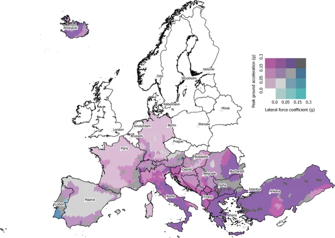
Publications Model of seismic design lateral force levels for the existing reinforced concrete European building stock Share Facebook LinkedIn Download 2021 | Peer-reviewed As part of the development of a European Seismic Risk Model 2020 (ESRM20), the spatial and temporal evolution of seismic design across Europe has been studied in order to better classify reinforced concrete buildings (which represent more than 30% of the approximately 145 million residential, commercial and industrial buildings in Europe) and map them to vulnerability models based on simulated seismic design. This paper summarises the model that has been developed to assign the years when different seismic design levels (low code, moderate code and high code) were introduced in a number of European countries and the associated lateral forces that were specified spatially within each country for the low and moderate codes for typical reinforced concrete mid-rise buildings. This process has led to an improved understanding of how design regulations evolved across Europe and how this has impacted the vulnerability of the European residential building stock. The model estimates that ~ 60% of the reinforced concrete buildings in Europe have been seismically designed, and of those buildings ~ 60% have been designed to low code, ~ 25% to moderate code and 15% to high code. This seismic design model aims at being a dynamic source of information that will be continuously updated with additional feedback from local experts and datasets. To this end, all of the data has been made openly available as shapefiles on a GitLab repository.
- TREQ capacity building: OQ online training updates - GEM Foundation
News TREQ capacity building: OQ online training updates By: Feb 19, 2021 Share Facebook LinkedIn The TREQ project is assessing earthquake risk at community level in three metropolitan centers in Latin America: Quito, Ecuador; Santiago de los Caballeros, Dominican Republic; and Cali, Colombia. In order to cope with the current pandemic, the GEM team shifted the capacity training and on-site workshops to online activities. Aiming to continue and strengthen the local participation in the project activities, 12 OpenQuake online training sessions (3 hours each) have been conducted for more than 200 people in several Latin American countries, with predominant participation from the three TREQ countries (Ecuador, Colombia, and Dominican Republic). The online workshops have increased the reach of the training sessions beyond its original scope. Free online working sessions are available through a dedicated website available in English and Spanish, https://www.training.openquake.org/, allowing participants around the globe to engage in OpenQuake training activities for earthquake hazard and risk assessment. The online sessions are divided into four modules that cover the basic concepts: Introduction to OpenQuake and Open Source Tools for Earthquake Hazard and Risk Assessment, Earthquake Scenarios, Probabilistic Seismic Hazard Assessment (PSHA), and Probabilistic Event-Based Risk Assessment. All the materials generated for the workshops have been incorporated into the training website. The project team has collected more than 200 responses with excellent and encouraging feedback, which helped the team to shape and improve the material and content of the training. Below is some of the feedback from the participants. “A great course! Very useful for us to start doing work using this great powerful software.” - Zivko Terzic, Melbourne, Australia "I really liked the experience and I would like to take this workshop to my students of the Master's Degree in Earthquake Engineering so that we can do research projects." - Maribel Guzman, PUCMM, Dominican Republic "Delighted with the information presented and the material is excellent, including the modeling software" - Hernán Suárez, Risk Management Unit - Municipality of Quito, Ecuador "Congratulations on the development of the tool and your training! Very very interesting and useful." - Srahyrlandy Rocio Díaz, Risk management secretariat, Cali, Colombia "Excellent explanations. Excellent materials and Excellent speakers" - Jonatan Arreola, CENAPRED, Mexico This year, the project completed the first part of the Earthquake Scenarios training on February 15th. Upcoming OpenQuake online training workshops are scheduled for February 22 and March. For more details, visit https://www.training.openquake.org/register. No images found. GALLERY 1/4 Gallery VIDEO RELATED CONTENTS
- Atlas - Global Seismic Hazard Curves | Global EarthQuake Model Foundation
A dynamic web portal and API featuring instant display and download of hazard curves worldwide Products Atlas - Global Seismic Hazard Curves A dynamic web portal and API featuring instant display and download of hazard curves worldwide Share Facebook LinkedIn Description ATLAS is a dynamic web portal and API, allowing subscribers to view the different layers of the Global Seismic Hazard Map in a GIS style mapviewer featuring instant display and download of hazard curves for the selected sites. This is a subscription service which provides clients with a pay-as-you-go alternative to licensing the GSHM data layers directly. Subscriptions permitting access to the ATLAS are available today; please contact GEM Products for details. Resellers, brokers and other organizations wishing to integrate the API into their workflows should contact GEM Products to discuss the terms of possible collaboration. How to cite this work N.A. Available Versions The ATLAS service is currently available as a dynamic web portal and as an API. Further information can be found in the ATLAS website where subscriptions to the web portal can be directly acquired. For the API, interested users are encouraged to contact GEM Products to discuss. License information Currently, the service is only available under a license that has to be tailored for each specific use case (public good or commercial). Please click "Subscribe here" to acquire a commercial license to the webportal or click on "License Request" for the API. Facebook LinkedIn Share Latest Version ATLAS 2.0 License Custom license Available resources ATLAS website Online Brochure Subscribe here License Request Terms of use text Map View Search Popup title Close Country/Region Available Resources Afghanistan Exposure Africa Exposure Alaska Exposure Country/Region Available Resources Afghanistan Vulnerability Africa Vulnerability Alaska Vulnerability Country/Region Resource Url Afghanistan Risk Profile Africa Risk Profile Alaska Risk Profile Search Found Country/Region Resource Url Afghanistan Exposure Africa Exposure Alaska Exposure Preview Preview is not available. Search Found Country/Region Resource Url Afghanistan Vulnerability Africa Vulnerability Alaska Vulnerability Preview Preview is not available. Search Found Country/Region Resource Url Afghanistan Risk Profile Africa Risk Profile Alaska Risk Profile Preview Preview is not available. Related products Global Liquefaction Hazard Global Exposure Model Global Vulnerability Model Global Seismic Embodied Carbon Risk Global Seismic Risk Map Country-Territory Seismic Risk Profiles OpenQuake Engine Global Seismic Hazard Map Related publications For downloading or accessing detailed product information like PNG/PDF maps, datasets, license request, shapefiles and more, please switch to a desktop or laptop computer. Thank you for your understanding.
- Global Exposure Model | Global EarthQuake Model Foundation
Comprehensive datasets of the residential, commercial and industrial building stock worldwide Products Global Exposure Model Comprehensive datasets of the residential, commercial and industrial building stock worldwide Share Facebook LinkedIn Description The v2026.1 Global Exposure Model is a mosaic of local and regional models with information regarding the residential, commercial, and industrial building stock at the smallest available administrative division of each country and includes details about the number of buildings, number of occupants, vulnerability characteristics, average built-up area, and average replacement cost. The dataset is developed and maintained by the GEM Foundation, using a bottom-up approach at the global scale, using national statistics, socio-economic data, and local datasets. The datasets employed to develop this model were provided by national institutions, or developed within the scope of regional programs or bilateral collaborations. The global maps and the underlying databases are based on best available and publicly accessible datasets and models. This model allows the identification of the most common types of construction worldwide, regions with large fractions of informal construction, and areas prone to natural disasters with a high concentration of population and building stock. The underlying datasets used to create the maps are available for all regions of the world, aggregated at Administrative Level 1 under a CC BY-NC-SA license, or further disaggregated to higher administraive units or 1km grid cells, under specific licenses. The open and downloadable Global Exposure Maps (v2026.1) in PNG format, represent the geographic distribution of residential, commercial and industrial buildings in terms of four exposure metrics: number of buildings, economic loss, number of occupants and the replacement embodied carbon. The data is presented on a hexagonal grid, with a spacing of 0.25 × 0.30 decimal degrees, corresponding to an area of about 1,700 km2 per cell. These maps can also be explored through the Geoviewer. How to cite this work If you make use of this work, please cite both the publication and the data. Publication: Yepes-Estrada, C., Calderon, A., Costa, C., Crowley, H., Dabbeek, J., Hoyos, M., Martins, L., Paul, N., Rao, A., Silva, V. (2023). Global Building Exposure Model for Earthquake Risk Assessment. Earthquake Spectra. doi:10.1177/87552930231194048 Data: Yepes-Estrada, C., Baiguera, M., Calderon, A., Caruso, M., Costa, C., Gonzalez, D., Nafeh, A.M.B., Rao, A., Silva, V. (2026). Global Exposure Model (2026.0.0). Zenodo. https://doi.org/10.5281/zenodo.8117363. Available Versions An open version (v2026.0.0) of the model, agreggated at Administrative Level 1, is available for direct download under a CC BY-NC-SA 4.0 license. Users interested in this version can click the "Open Repository" button in the right panel to access the information. The full version for any country/territory, at the highest resolution available or disaggregated to 1km grid cells, can be requested by clicking on the "License Request", where a specific license will be provided, depending on the use case. Additionally, users interested in the previous versions of the Global Exposure Maps can access these from the table at the bottom of this page. License information The open version is available under a Creative Commons CC BY-NC-SA 4.0 license, which requires: Attribution (you must give appropriate credit, provide a link to the license, and indicate if changes were made) Non-commercial (you may not use the material for commercial purposes) ShareAlike (derivatives created must be made available under the same license as the original) Any deviation from these terms incur in license infringement. For commercial use of the dataset, a specific license agreement must be made tailored to your use case, in such instance please click on "License Request". Facebook LinkedIn Share Latest Version v2026.1 License CC BY-NC-SA 4.0 Available resources Open Repository Geoviewer PNG Documentation License Request Acknowledgements By selecting a region in the global map below, a table will appear with the region, country, or territory for which GEM currently has exposure models. You can also use the Search box to find a specific country or territory's exposure model. Map View Search Popup title Close Country/Region Available Resources Afghanistan Exposure Africa Exposure Alaska Exposure Country/Region Available Resources Afghanistan Vulnerability Africa Vulnerability Alaska Vulnerability Country/Region Resource Url Afghanistan Risk Profile Africa Risk Profile Alaska Risk Profile Search Found Country/Region Resource Url Afghanistan Exposure Africa Exposure Alaska Exposure Preview Preview is not available. Search Found Country/Region Resource Url Afghanistan Vulnerability Africa Vulnerability Alaska Vulnerability Preview Preview is not available. Search Found Country/Region Resource Url Afghanistan Risk Profile Africa Risk Profile Alaska Risk Profile Preview Preview is not available. Previous Product Versions Product Version Data Image Poster Documentation Geoviewer v2018.1 N/A N/A PDF Silva et al. (2020) View v2023.1 Repository PNG PDF Read View Related products GEM Building Taxonomy Global Seismic Embodied Carbon Risk Global Seismic Risk Map Country-Territory Seismic Risk Profiles Global Liquefaction Hazard OpenQuake Engine Global Seismic Hazard Map Global Map of Road Exposure to Ground Shaking and Liquefaction Global Exposure Model Global Vulnerability Model Related publications Global building exposure model for earthquake risk assessment Read More Development of a global seismic risk model Read More For downloading or accessing detailed product information like PNG/PDF maps, datasets, license request, shapefiles and more, please switch to a desktop or laptop computer. Thank you for your understanding.
- New Horizon 2020 project launched to develop an advanced approach for Seismic Risk Assessment of Nuclear Power Plants - GEM Foundation
News New Horizon 2020 project launched to develop an advanced approach for Seismic Risk Assessment of Nuclear Power Plants By: Nov 3, 2020 Share Facebook LinkedIn The METHODS AND TOOLS INNOVATIONS FOR SEISMIC RISK ASSESSMENT (METIS) H2020 Project has been officially launched opening a promising research collaboration to improve confidence in nuclear safety by advancing the approach utilised for seismic safety assessments for Nuclear Power Plants. The major goal of METIS is to propose innovations in tools and methodologies for seismic safety assessment of reactors, and supporting technology transfer from the research community to the industry. It aims to develop common guidelines for seismic safety assessment at the European level, in line with international practice and consensus, and promote good practices across the community. The outcome contributes to facilitate risk-informed decision-making in the European context. The advanced tools and methodologies developed by METIS will be made available to a wider community thanks to the capitalisation in modern high-performance open source tools as OpenQuake, code_aster/ salome_meca, OpenSees, and SCRAM. METIS is an EU-funded 4-year project under the Horizon 2020 EURATOM Programme for Research and Innovation having a total budget of €5 million, of which €4 million is funded from the European Commission. The project will be delivered by an international consortium gathering 13 European partners from France, Germany, Italy, Greece, UK, Ukraine and Slovenia alongside with 3 organisations from US and Japan. The consortium brings together universities, research organisations and industrials so as to create an ideal ecosystem for research, development, and its dissemination and application by end users. The consortium had a virtual kick off meeting held over two days 29th-30th September 2020 attended by 78 participants. The first day was the plenary session which outlined all the Work Packages’ (WP) and on the second day, there was a WP coordination session for more detailed discussion. “We are really excited to start this project, where we aim to improve confidence in nuclear power plants and their competitiveness using advanced seismic safety assessments. In these challenging times, we had a successful collaboration with all the partners to build up METIS and get it funded by H2020 Programme. Our recent kick-off meeting, while held remotely, was a really successful event with high engagement from all partners promising a rich and effective collaboration going forward.” Electricté de France EDF R&D UK Centre Limited Liability Company Energorisk Fondazione GEM GeoForschungsZentrum Institut de Radioprotection et de Sûreté Nucléaire University School for Advanced Studies Pavia LGI National Technical University of Athens Géodynamique et Structures State Scientific and Technical Center for Nuclear and Radiation Safety Technical University of Kaiserslautern University of Ljubljana Geotechnical Research Institute North Carolina State University Pacific Earthquake Engineering Research Institute For further information contact: Emma.Luguterah@edfenergy.com or 0208 935 2714 Electricité de France (EDF) was set up in 1946 out of the desire to have a national electrical utility that could help rebuild the country after the Second World War. Since its creation, the company has had the responsibility for generating, transmitting, and distributing electricity in France. EDF remains one of the European utilities with a significant R&D activity and effort on innovation. Around 2500 people are presently employed at EDF R&D, amongst which, 70% are researchers and executives. EDF is today one of the leading energy companies, with solid positions in major European countries. EDF is committed to creating long term, low carbon affordable energy and the safety and sustained performance of nuclear and hydraulic plants is one of the key issues in this regard. EDF participates in the project through its research and development (R&D) unit. EDF R&D has the mission to contribute to increasing performance, efficiency and safety of operating units of EDF Group. Collaborative research projects are a vital component for EDF, creating an invaluable forum for exchange and knowledge-sharing. Through them, innovations are developed, disseminated, and industrialized. EDF R&D is also a major national player in opensource simulation software development and dissemination. In particular, it develops and disseminates code_aster opensource Finite Elements Software www.code-aster.org. Website address: Horizon 2020 is the biggest EU Research and Innovation programme ever with nearly €80 billion of funding available over 7 years (2014 to 2020) In addition to the private investment that this money will attract. It promises more breakthroughs, discoveries and world-firsts by taking great ideas from the lab to the market. Horizon 2020 is the financial instrument implementing the Innovation Union, a Europe 2020 flagship initiative aimed at securing Europe's global competitiveness. EURATOM aims to pursue nuclear research and training activities with an emphasis on continually improving nuclear safety, security and radiation protection, notably to contribute to the long-term decarbonisation of the energy system in a safe, efficient and secure way. By contributing to these objectives, the Euratom Programme will reinforce outcomes under the three priorities of Horizon 2020: Excellent science, Industrial leadership and Societal challenges No images found. GALLERY 1/0 Gallery VIDEO RELATED CONTENTS