Thanks for submitting!
You will be contacted as soon as possible


QUICK LINKS


PROFILES
PUBLICATIONS
EXPOSURE
VULNERABILTY
SOFTWARE
EQ MODELS
Search Results
1046 results found with an empty search
- COMET GEM | Global Earthquake Model Foundation
Projects COMET GEM COMET-GEM Central Asia Seismic Hazard Project Versión en español English version Share Facebook LinkedIn Overview Anchor 6 Background Since 2021, COMET and GEM have partnered to integrate the latest advancements in earthquake science into seismic hazard and risk modeling. The first phase of the collaboration (2020–2022) focused on building essential datasets, including an active fault database, a homogenized earthquake catalog, GNSS data, and a preliminary seismic hazard model for Central Asia. The ongoing second phase (2023–2025), supported by the Natural Environment Research Council (NERC), UK, expands on these efforts by incorporating time-dependent hazard modeling, earthquake clustering analysis, and geodetic data processing. By bridging scientific research with practical applications, the collaboration ensures that hazard models remain at the forefront of earthquake risk assessment, strengthening disaster preparedness efforts in Central Asia and beyond. Duration: Phase 1: 2021 -2023, Phase 2: 2023 - 2025 More details: https://comet.nerc.ac.uk/ Overall Objective The COMET-GEM collaboration aims to develop an advanced, publicly accessible seismic hazard and risk model for Central Asia, integrating cutting-edge scientific methods such as satellite geodesy, palaeoseismology, and geodetic data analysis. The goal is to provide local communities, researchers, and policymakers with robust hazard and risk assessments to inform disaster risk reduction strategies and enhance preparedness for future seismic events. Specific Objectives / Expected Outputs 1. Enhancing Seismic Hazard Models Refining fault databases, earthquake catalogs, and strain rate fields to improve hazard predictions. Incorporating time-dependent earthquake occurrence models and earthquake clustering analysis to improve forecasting. 2. Integrating Advanced Scientific Techniques Utilizing InSAR-based deformation data and GNSS datasets to quantify seismic strain accumulation across Central Asia. Developing high-resolution geodetic velocity fields for improved hazard modeling. 3. Supporting Disaster Risk Reduction Integrating hazard models into seismic risk assessments to estimate economic and human losses. Engaging local communities and stakeholders in seismic hazard model development. 4. Collaborative Research and Capacity Building Hosting workshops and training sessions to enhance regional expertise in seismic hazard assessment. Supporting research collaborations in Central Asia, the South Caucasus, and beyond. Collaborators Project Coordination: COMET and GEM, with contributions from UK-based institutions Global Earthquake Model (GEM) Foundation COMET (Centre for Observation and Modelling of Earthquakes, Volcanoes & Tectonics) British Geological Survey (BGS) University of Oxford (geologic data compilation) University of Leeds (geodetic data processing) Various local and international research institutions Funding Partner: Natural Environment Research Council (NERC), UK Locations Primary Focus Region: Central Asia Additional Areas of Study: South Caucasus, Türkiye, Mongolia Anchor 1 Anchor 5 Anchor 4 Anchor3 Publications
- ALBANIA HAZARD MODELLING | Global Earthquake Model Foundation
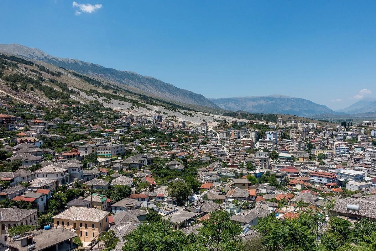
Projects ALBANIA HAZARD MODELLING Joint development of the Albanian seismic hazard model Versión en español English version Share Facebook LinkedIn Overview Outcomes Training Outreach Photos Publications Anchor 6 Background GEM and IGEO-Albania are currently implementing a 1-year project funded by the European Investment Fund and supported by the Electrical Corporation of Albania to update Albania’s probabilistic seismic hazard model through a series of technical workshops. The GEM Hazard Team is providing support on the use of its open source tools for hazard model building and assessment. Duration: 2023 Objectives The main objectives of this project are to update the national seismic hazard model for Albania, and provide the outputs that can be used in the National Annex of Eurocode 8, for the seismic design of buildings in Albania. Collaborators GEM Foundation, Institute of Geosciences (IGEO) Funding Partner: European Investment Fund, Electrical Corporation of Albania Location Albania Anchor 1 Anchor 5 Anchor 4 Strengthening Albania's Earthquake Preparedness: A Collaborative Effort This project, funded by the Central European Initiative and supported by the Albanian Electricity Corporation, has two objectives. It aims to modernize Albania's seismic hazard map, a crucial step in updating the nation's building code to meet Eurocode 8 standards. This marks the first significant revision to Albania's building regulations since 1989. A more updated view of seismic hazard will help in promoting more cost-effective earthquake-resistant construction practices. Read more Albania’s Institute of Geosciences (IGEO) and GEM collaborate to update the national seismic hazard model GEM and IGEO-Albania implemented a 1-year project funded by the Central European Initiative (CEI - https://www.cei.int/) and the Albanian Electricity Corporation (KESH - https://www.kesh.al/en/) to update Albania's probabilistic seismic hazard model through a series of technical workshops. Read more Anchor3 BUSINESS NEWS NSHMA 2024 Presentation, Tirana, Albania - July 16, 2024 Photo credits: IGEO 1/3 BUSINESS NEWS GEM - IGEO Albania Workshop, Pavia 2023 1/4 Publications
- READY2RESPOND | Global Earthquake Model Foundation
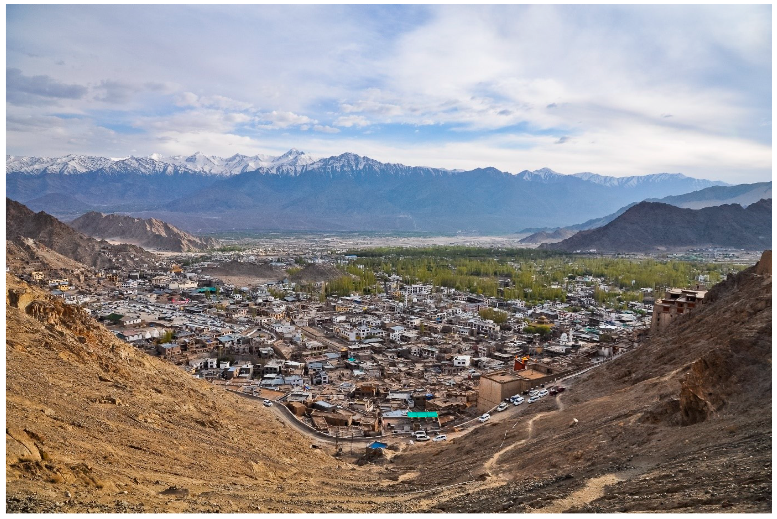
Projects READY2RESPOND Rapid Diagnostic in Uttarakhand and Himachal Pradesh Versión en español English version Share Facebook LinkedIn Overview Anchor 6 Background Ready2Respond (R2R) is a rapid diagnostic guide, designed to improve national, sub-national and city resilience mechanisms and to protect development gains through investments in emergency preparedness and response systems. It is informed by the World Bank Group (WBG) City Resilience Program (CRP) and other WBG resilience platforms. In this project R2R is applied to the Uttarakhand and Himachal Pradesh states in the Himalayan region of India. The GEM Risk Team contributes to the project by providing: Literature review and stakeholder mapping around hazard and risk initiatives, risk data and models for both states Provision of seismic hazard/risk model outputs and related descriptive information for both states (to support diagnostic activities) Review of legal regulation of the built environment and associated initiatives Review of seismic preparedness of the critical infrastructure defined in the project Preparation and remote input into stakeholder workshops Duration: 2023 Objectives This project responds to the need to provide effective and comprehensive diagnosis of the Uttarakhand and Himachal Pradesh states’ emergency preparedness and response systems in the Himalayan region of India. This enables the World Bank and the government to tailor investments to strengthen institutional capacity and capability, ensure public safety, and limit economic disruption in the face of multiple, and often cascading, geological and hydrometeorological hazards. Collaborators GEM Foundation, JBA Consulting, Geo Climate Risk Solutions (GCRS) Funding partner: World Bank Group Location India Himalayas Anchor 1 Anchor 5 Anchor 4 Anchor3 Publications
- Collaborative Projects | Global Earthquake Model Foundation | Italy
Hazard and risk assessment projects with regional, national and local collaborators covering more than 150 countries in Europe, Middle East, South America, Central America, North America, Sub-Saharan Africa, Asia and the Pacific. PROJECTS GEM’s collaborative network comprises more than 100 public and private institutions, which has led to GEM’s participation in more than 50 regional, national, and multilateral projects covering Europe, Middle East, South America, Central America, North America, Sub-Saharan Africa, Asia and the Pacific. Share Facebook LinkedIn Anchor 1 Key Projects - 2013 and beyond Sort by Order by 1 2 3 4 5 1 ... 1 2 3 4 5 6 7 8 9 ... 9 0 Filters: 44 results found View: Map List Gallery SeismIc hazard and Ground Motion Assessment Status: Ongoing The SIGMA program is a Research and Development project about seismic hazard and ground motion. View Piattaforma Analisi Pericolosità E Rischio Sismico Status: Ongoing The Global Earthquake Model (GEM) Foundation has launched the PAPERS project (Piattaforma Analisi Pericolosità E Rischio Sismico), an initiative aimed at developing a new WebGIS platform for scenario hazard and risk assessment in Italy. The project has been funded as one of the cascade grants launched by the High-Performance Computing, Big Data e Quantum Computing Research Centre, one of the five National Centres established by the Italian National Recovery and Resilience Plan (NRRP), under Spoke 5 - Environment and Natural Disasters . View COMET-GEM Central Asia Seismic Hazard Project Status: Ongoing The COMET-GEM collaboration aims to develop an advanced, publicly accessible seismic hazard and risk model for Central Asia, integrating cutting-edge scientific methods such as satellite geodesy, palaeoseismology, and geodetic data analysis. View WFP-ADAM+ Innovation Accelerator Project Status: Ongoing The project aims to integrate GEM’s earthquake risk methodologies and datasets into humanitarian emergency preparedness and response efforts. By leveraging GEM’s expertise, the project seeks to enhance global access to reliable earthquake risk data and post-disaster impact assessments for humanitarian actors. View Renovation with automation and optimization of processes and products Status: Ongoing This EU-funded initiative, supported by CINEA - European Climate, Infrastructure and Environment Executive Agency as the granting authority, is set to transform the renovation process by introducing advanced solutions that streamline every stage - from design to end-of-life - achieving significant cost and time savings. View Title Location Status SeismIc hazard and Ground Motion Assessment Ongoing Piattaforma Analisi Pericolosità E Rischio Sismico Pilot Site for Seismic Risk Analysis: An Italian city to be determined during the project, intended as a demonstration case for urban-scale seismic risk analysis. Testing Locations: The project will involve data collection and analysis on a national scale across Italy. Ongoing COMET-GEM Central Asia Seismic Hazard Project Primary Focus Region: Central Asia Additional Areas of Study: South Caucasus, Türkiye, Mongolia Ongoing WFP-ADAM+ Innovation Accelerator Project Earthquake-prone WFP Countries with initial pilots in Afghanistan, Nepal, Turkey, Syria, Haiti, and the Philippines. Ongoing Renovation with automation and optimization of processes and products Austria Ongoing North-Eastern Atlantic and Mediterranean Tsunami Risk Management and Planning Southern Europe Ongoing European Plate Observing System-Optimisation and EvolutioN (EPOS ON) Project Europe Ongoing ASCE Earthquake Loads Overseas (AELO) Global (Washington DC, USA) Ongoing Strengthening capacity on disaster risk assessment, reduction and transfer instruments in Mongolia Mongolia Completed Assessing the Risk Exposure of Road Network to Climate and Natural Hazard Risks in Solomon Islands Solomon Islands Completed Page 1 of 5 1 2 3 4 5 1 ... 1 2 3 4 5 6 7 8 9 ... 9 Completed Ongoing Washington DC Close Completed Location Ongoing
- AZERBAIJAN DRR | Global Earthquake Model Foundation
Projects AZERBAIJAN DRR Risk modeling and scenario analysis for Azerbaijan - Seismic risk analysis Versión en español English version Share Facebook LinkedIn Overview Anchor 6 Background One of the analyses to be conducted under the World Bank Groups' Country Climate and Development Reports (CCDRs), is to look at the fiscal and economic impacts of disasters in Azerbaijan, including the size of the macro-fiscal risk posed by earthquakes, floods, and droughts, and identify potential opportunities to increase financial resilience. For the risk modeling and scenario analysis for Azerbaijan, the GEM Risk Team further expands the Azerbaijan model in GEM's Global Seismic Risk Model, by projecting the exposure and risk to 2050 by taking into account the evolving demographics and socio-economic conditions in Azerbaijan. Duration: 2022 Objectives The World Bank is preparing the Country Climate and Development Report for Azerbaijan. The CCDR aims to inform policy dialogue and engagement with the Government of Azerbaijan. This provides an opportunity to carry out several analytical pieces, including in the area of Disaster Risk Management, bringing together existing knowledge on the economic and social impacts of disasters and climate change, and delivering new analytical insights to support policy recommendations. Collaborators GEM Foundation Funding partner: World Bank Group Location Azerbaijan Anchor 1 Anchor 5 Anchor 4 Anchor3 Publications
- Global Earthquake Model Foundation | Italy
Global Earthquake Model Foundation: For a world that is resilient to earthquakes through earthquake hazard and risk assessment. Global Earthquake Model foundation For a world that is resilient to earthquakes and other natural hazards. Latest RED ALERT Earthquake: 31st August 2025 M6.0 Afghanistan More Details What We Do Our purpose is to develop, together with the global community, scientific resources for transparent earthquake hazard and risk assessment, and to facilitate their application for risk management. PROVIDE Global standards for earthquake hazard and risk modelling. SUPPORT Partner with communities for disaster risk reduction STRENGTHEN Build capacity, especially in the Global South Latest Updates Newsletter GEM Newsletter – Q3 2025 Edition Science in Action: From Earthquake Response to Building Global Resilience More Conference GEM2026 Conference Registration is now open! More Webinar Resources 15 Years of the OpenQuake Engine: From Models to Risk-Informed Policy and Investment More Available Seismic Hazard and Risk Models and Datasets By selecting a region in the global map below, a table will appear to quickly take you to the available resources in that region. You can also use the Search box to look up any specific region, country or territory. Popup title Close Country/Region North and South Korea Hazard Exposure Vulnerability Risk Profile Conterminous US Hazard Exposure Vulnerability Risk Profile Northwest Asia Hazard Exposure Vulnerability Risk Profile Northeast Asia Hazard Exposure Vulnerability Risk Profile Pacific Islands Hazard Exposure Vulnerability Risk Profile Hawaii Hazard Exposure Vulnerability Risk Profile Arabia Hazard Exposure Vulnerability Risk Profile Alaska Hazard Exposure Vulnerability Risk Profile Sub-Saharan Africa Hazard Exposure Vulnerability Risk Profile West Africa Hazard Exposure Vulnerability Risk Profile North Africa Hazard Exposure Vulnerability Risk Profile Tuvalu Hazard Exposure Vulnerability Risk Profile Uganda Hazard Exposure Vulnerability Risk Profile Ukraine Hazard Exposure Vulnerability Risk Profile United Arab Emirates Hazard Exposure Vulnerability Risk Profile United Kingdom Hazard Exposure Vulnerability Risk Profile United States of America Hazard Exposure Vulnerability Risk Profile Uruguay Hazard Exposure Vulnerability Risk Profile US Virgin Islands Hazard Exposure Vulnerability Risk Profile Uzbekistan Hazard Exposure Vulnerability Risk Profile Vanuatu Hazard Exposure Vulnerability Risk Profile Venezuela Hazard Exposure Vulnerability Risk Profile Vietnam Hazard Exposure Vulnerability Risk Profile Yemen Hazard Exposure Vulnerability Risk Profile Zambia Hazard Exposure Vulnerability Risk Profile Zimbabwe Hazard Exposure Vulnerability Risk Profile Africa Hazard Exposure Vulnerability Risk Profile Caribbean Central America Hazard Exposure Vulnerability Risk Profile Central Asia Hazard Exposure Vulnerability Risk Profile East Asia Hazard Exposure Vulnerability Risk Profile Europe Hazard Exposure Vulnerability Risk Profile Middle East Hazard Exposure Vulnerability Risk Profile North America Hazard Exposure Vulnerability Risk Profile North Asia Hazard Exposure Vulnerability Risk Profile Oceania Hazard Exposure Vulnerability Risk Profile South America Hazard Exposure Vulnerability Risk Profile South Asia Hazard Exposure Vulnerability Risk Profile Southeast Asia Hazard Exposure Vulnerability Risk Profile Palestine Hazard Exposure Vulnerability Risk Profile Panama Hazard Exposure Vulnerability Risk Profile Papua New Guinea Hazard Exposure Vulnerability Risk Profile Paraguay Hazard Exposure Vulnerability Risk Profile Peru Hazard Exposure Vulnerability Risk Profile Philippines Hazard Exposure Vulnerability Risk Profile Poland Hazard Exposure Vulnerability Risk Profile Portugal Hazard Exposure Vulnerability Risk Profile Puerto Rico Hazard Exposure Vulnerability Risk Profile Qatar Hazard Exposure Vulnerability Risk Profile Romania Hazard Exposure Vulnerability Risk Profile Russia Hazard Exposure Vulnerability Risk Profile Rwanda Hazard Exposure Vulnerability Risk Profile Saint Kitts and Nevis Hazard Exposure Vulnerability Risk Profile Saint Lucia Hazard Exposure Vulnerability Risk Profile Saint Vincent and the Grenadines Hazard Exposure Vulnerability Risk Profile Samoa Hazard Exposure Vulnerability Risk Profile Sao Tome and Principe Hazard Exposure Vulnerability Risk Profile Saudi Arabia Hazard Exposure Vulnerability Risk Profile Senegal Hazard Exposure Vulnerability Risk Profile Serbia Hazard Exposure Vulnerability Risk Profile Seychelles Hazard Exposure Vulnerability Risk Profile Sierra Leone Hazard Exposure Vulnerability Risk Profile Singapore Hazard Exposure Vulnerability Risk Profile Slovakia Hazard Exposure Vulnerability Risk Profile Slovenia Hazard Exposure Vulnerability Risk Profile Solomon Islands Hazard Exposure Vulnerability Risk Profile Somalia Hazard Exposure Vulnerability Risk Profile South Africa Hazard Exposure Vulnerability Risk Profile South Korea Hazard Exposure Vulnerability Risk Profile South Sudan Hazard Exposure Vulnerability Risk Profile Spain Hazard Exposure Vulnerability Risk Profile Sri Lanka Hazard Exposure Vulnerability Risk Profile Sudan Hazard Exposure Vulnerability Risk Profile Suriname Hazard Exposure Vulnerability Risk Profile Sweden Hazard Exposure Vulnerability Risk Profile Switzerland Hazard Exposure Vulnerability Risk Profile Syria Hazard Exposure Vulnerability Risk Profile Taiwan Hazard Exposure Vulnerability Risk Profile Tajikistan Hazard Exposure Vulnerability Risk Profile Tanzania Hazard Exposure Vulnerability Risk Profile Thailand Hazard Exposure Vulnerability Risk Profile Timor Leste Hazard Exposure Vulnerability Risk Profile Togo Hazard Exposure Vulnerability Risk Profile Tonga Hazard Exposure Vulnerability Risk Profile Trinidad and Tobago Hazard Exposure Vulnerability Risk Profile Tunisia Hazard Exposure Vulnerability Risk Profile Turkey Hazard Exposure Vulnerability Risk Profile Turkmenistan Hazard Exposure Vulnerability Risk Profile Turks and Caicos Islands Hazard Exposure Vulnerability Risk Profile Kiribati Hazard Exposure Vulnerability Risk Profile Kosovo Hazard Exposure Vulnerability Risk Profile Kuwait Hazard Exposure Vulnerability Risk Profile Kyrgyzstan Hazard Exposure Vulnerability Risk Profile Laos Hazard Exposure Vulnerability Risk Profile Latvia Hazard Exposure Vulnerability Risk Profile Lebanon Hazard Exposure Vulnerability Risk Profile Lesotho Hazard Exposure Vulnerability Risk Profile Liberia Hazard Exposure Vulnerability Risk Profile Libya Hazard Exposure Vulnerability Risk Profile Liechtenstein Hazard Exposure Vulnerability Risk Profile Lithuania Hazard Exposure Vulnerability Risk Profile Luxembourg Hazard Exposure Vulnerability Risk Profile Macao Hazard Exposure Vulnerability Risk Profile Madagascar Hazard Exposure Vulnerability Risk Profile Malawi Hazard Exposure Vulnerability Risk Profile Malaysia Hazard Exposure Vulnerability Risk Profile Mali Hazard Exposure Vulnerability Risk Profile Malta Hazard Exposure Vulnerability Risk Profile Marshall Islands Hazard Exposure Vulnerability Risk Profile Martinique Hazard Exposure Vulnerability Risk Profile Mauritania Hazard Exposure Vulnerability Risk Profile Mauritius Hazard Exposure Vulnerability Risk Profile Mexico Hazard Exposure Vulnerability Risk Profile Micronesia Hazard Exposure Vulnerability Risk Profile Moldova Hazard Exposure Vulnerability Risk Profile Monaco Hazard Exposure Vulnerability Risk Profile Mongolia Hazard Exposure Vulnerability Risk Profile Montenegro Hazard Exposure Vulnerability Risk Profile Montserrat Hazard Exposure Vulnerability Risk Profile Morocco Hazard Exposure Vulnerability Risk Profile Mozambique Hazard Exposure Vulnerability Risk Profile Myanmar Hazard Exposure Vulnerability Risk Profile Namibia Hazard Exposure Vulnerability Risk Profile Nauru Hazard Exposure Vulnerability Risk Profile Nepal Hazard Exposure Vulnerability Risk Profile Netherlands Hazard Exposure Vulnerability Risk Profile New Caledonia Hazard Exposure Vulnerability Risk Profile New Zealand Hazard Exposure Vulnerability Risk Profile Nicaragua Hazard Exposure Vulnerability Risk Profile Niger Hazard Exposure Vulnerability Risk Profile Nigeria Hazard Exposure Vulnerability Risk Profile Niue Hazard Exposure Vulnerability Risk Profile North Korea Hazard Exposure Vulnerability Risk Profile North Macedonia Hazard Exposure Vulnerability Risk Profile Northern Mariana Islands Hazard Exposure Vulnerability Risk Profile Norway Hazard Exposure Vulnerability Risk Profile Oman Hazard Exposure Vulnerability Risk Profile Pakistan Hazard Exposure Vulnerability Risk Profile Palau Hazard Exposure Vulnerability Risk Profile Democratic Republic of the Congo Hazard Exposure Vulnerability Risk Profile Denmark Hazard Exposure Vulnerability Risk Profile Djibouti Hazard Exposure Vulnerability Risk Profile Dominica Hazard Exposure Vulnerability Risk Profile Dominican Republic Hazard Exposure Vulnerability Risk Profile Ecuador Hazard Exposure Vulnerability Risk Profile Egypt Hazard Exposure Vulnerability Risk Profile El Salvador Hazard Exposure Vulnerability Risk Profile Equatorial Guinea Hazard Exposure Vulnerability Risk Profile Eritrea Hazard Exposure Vulnerability Risk Profile Estonia Hazard Exposure Vulnerability Risk Profile Eswatini Hazard Exposure Vulnerability Risk Profile Ethiopia Hazard Exposure Vulnerability Risk Profile Fiji Hazard Exposure Vulnerability Risk Profile Finland Hazard Exposure Vulnerability Risk Profile France Hazard Exposure Vulnerability Risk Profile French Guiana Hazard Exposure Vulnerability Risk Profile Gabon Hazard Exposure Vulnerability Risk Profile Gambia Hazard Exposure Vulnerability Risk Profile Georgia Hazard Exposure Vulnerability Risk Profile Germany Hazard Exposure Vulnerability Risk Profile Ghana Hazard Exposure Vulnerability Risk Profile Gibraltar Hazard Exposure Vulnerability Risk Profile Greece Hazard Exposure Vulnerability Risk Profile Grenada Hazard Exposure Vulnerability Risk Profile Guadeloupe Hazard Exposure Vulnerability Risk Profile Guam Hazard Exposure Vulnerability Risk Profile Guatemala Hazard Exposure Vulnerability Risk Profile Guinea Hazard Exposure Vulnerability Risk Profile Guinea Bissau Hazard Exposure Vulnerability Risk Profile Guyana Hazard Exposure Vulnerability Risk Profile Haiti Hazard Exposure Vulnerability Risk Profile Honduras Hazard Exposure Vulnerability Risk Profile Hong Kong Hazard Exposure Vulnerability Risk Profile Hungary Hazard Exposure Vulnerability Risk Profile Iceland Hazard Exposure Vulnerability Risk Profile India Hazard Exposure Vulnerability Risk Profile Indonesia Hazard Exposure Vulnerability Risk Profile Iran Hazard Exposure Vulnerability Risk Profile Iraq Hazard Exposure Vulnerability Risk Profile Ireland Hazard Exposure Vulnerability Risk Profile Isle of Man Hazard Exposure Vulnerability Risk Profile Israel Hazard Exposure Vulnerability Risk Profile Italy Hazard Exposure Vulnerability Risk Profile Ivory Coast Hazard Exposure Vulnerability Risk Profile Jamaica Hazard Exposure Vulnerability Risk Profile Japan Hazard Exposure Vulnerability Risk Profile Jordan Hazard Exposure Vulnerability Risk Profile Kazakhstan Hazard Exposure Vulnerability Risk Profile Kenya Hazard Exposure Vulnerability Risk Profile Afghanistan Hazard Exposure Vulnerability Risk Profile Albania Hazard Exposure Vulnerability Risk Profile Algeria Hazard Exposure Vulnerability Risk Profile American Samoa Hazard Exposure Vulnerability Risk Profile Andorra Hazard Exposure Vulnerability Risk Profile Angola Hazard Exposure Vulnerability Risk Profile Anguilla Hazard Exposure Vulnerability Risk Profile Antigua and Barbuda Hazard Exposure Vulnerability Risk Profile Argentina Hazard Exposure Vulnerability Risk Profile Armenia Hazard Exposure Vulnerability Risk Profile Aruba Hazard Exposure Vulnerability Risk Profile Australia Hazard Exposure Vulnerability Risk Profile More Products Downloadable Resources OpenQuake OpenQuake Engine Risk Profiles Country-Territory Seismic Risk Profiles Risk Global Seismic Risk Map Exposure Global Exposure Map Hazard Global Seismic Hazard Map Vulnerability Global Vulnerability Model Collaborative Projects Close Completed Location Ongoing More Projects
- Project locations world map | GEM Foundation
Close Completed Location Ongoing
- Evolution of the OpenQuake Engine: Enhanced capabilities, collaborative development, and global adoption | GEM Foundation
Publications Evolution of the OpenQuake Engine: Enhanced capabilities, collaborative development, and global adoption Share Facebook LinkedIn Download 2025 | Peer-reviewed The OpenQuake Engine started being developed in 2010 and was publicly introduced in 2014 as an open-source software for seismic hazard and risk modeling, aiming to provide a transparent, flexible, and globally accessible platform to the earthquake engineering and hazard science communities. Over the subsequent decade, extensive advancements have significantly expanded its capabilities and enhanced its adoption worldwide. This article comprehensively reviews these developments, detailing the new computational workflows and features implemented in the OpenQuake Engine with an emphasis on the risk component, improvements in its computational efficiency and scalability, and its growing global application across diverse geographical and thematic contexts. Major improvements to the OpenQuake Engine include the earthquake-triggered landslide and liquefaction modules, the infrastructure risk and network connectivity analysis module, the post-event loss amplification module, the financial loss module for insured and reinsured loss calculations, the classical and event-based probabilistic damage calculators, and the site-amplification module. Additional features include the option to condition ground motion fields on station data in scenario calculations, ability to connect ShakeMap outputs to the OpenQuake Engine’s damage and loss calculators, the conditional spectra calculator, vector-valued PSHA, and extension of the risk calculators to volcanic hazards. Performance improvements and enhancements in documentation have been pivotal in strengthening the software’s usability across a variety of computational platforms and user groups. A core contribution of this article lies in compiling and synthesizing over a hundred studies conducted using the OpenQuake Engine, thereby illustrating its versatile application at national, regional, urban, and site-specific scales. Moreover, examples of its use in earthquake insurance pricing and parametric catastrophe bond design are highlighted, demonstrating its practical relevance to risk management and financial resilience. Reflections on lessons learned regarding the importance of open-source practices, robust documentation, sustained user engagement, and interdisciplinary collaboration are discussed to inform future development and maintenance of scientific software with global applications.
- Publications | GEM Foundation
Papers, articles and reports are released as part of GEM's advancing science & knowledge-sharing initiatives. Selected reports and other materials produced by the international consortia on global projects, working groups and regional collaborations can also be found below. PUBLICATIONS Papers, articles and reports are released as part of GEM's advancing science & knowledge-sharing initiatives. Selected reports and other materials produced by the international consortia on global projects, working groups and regional collaborations can also be found below. Share Facebook LinkedIn Featured Publications Development of a global seismic risk model GEM Strategic Plan and Roadmap to 2030 Improving Post-Disaster Damage Data Collection to Inform Decision-Making Final Report Anchor 1 Publications List 0 Sort by Title: A-Z Z-A List Gallery Download ATLAS 2.0: Ground-shaking intensities at multiple return periods all over the world Type: Brochure Year: 2024 ATLAS 2.0 is GEM’s new hazard data service that allows users to access and interact with the outputs from the GEM Global Mosaic, used to generate the Global Seismic Hazard Maps. Available for public-good and commercial applications, users can now access full sets of hazard curves that describe the intensity of ground-shaking for different soil conditions, at multiple return periods, all over the world. Details Download Quantify Your Earthquake Risk: Expert Solutions from the GEM Foundation Type: Brochure Year: 2024 A quick glance of GEM's commercially available scientifically robust risk information and flagship products. The brochure also highlights GEM's collaborative projects globally for public good. Details Download Building a World Resilient to Earthquakes and other Natural Hazards Type: Brochure Year: 2024 An overview of the GEM Foundation's history, collaborative and transparent approach, pioneering scientific tools such as the OpenQuake Engine and the benefits of supporting GEM. Details Download Global building exposure model for earthquake risk assessment Type: Peer-reviewed Year: 2023 The global building exposure model is a mosaic of local and regional models with information regarding the residential, commercial, and industrial building stock at the smallest available administrative division of each country and includes details about the number of buildings, number of occupants, vulnerability characteristics, average built-up area, and average replacement cost. We aimed for a bottom-up approach at the global scale, using national statistics, socio-economic data, and local datasets. This model allows the identification of the most common types of construction worldwide, regions with large fractions of informal construction, and areas prone to earthquakes with a high concentration of population and building stock. The mosaic of exposure models presented herein can be used for the assessment of probabilistic seismic risk and earthquake scenarios. Information at the global, regional, and national levels is available through a public repository (https://github.com/gem/global_exposure_model), which will be used to maintain, update and improve the models. Details Download Development of a global seismic risk model Type: Peer-reviewed Year: 2020 The Development of a Global Seismic Risk Model was a mammoth undertaking that involved hundreds of people and for the first time presented a detailed view of seismic risk at the global scale. For some developing countries, this was the first time that a seismic risk map was produced, and the associated country profiles are being used by the local authorities. Details Download GEM Strategic Plan and Roadmap to 2030 Type: Brochure Year: 2022 GEM was founded in 2009 with the purpose of improving the global knowledge of earthquake risk and contributing to the reduction of risk worldwide. In 13 years, GEM has become widely known for its global effort to improve the state of practice of earthquake hazard and risk assessment and for its contribution to improving the state of knowledge of earthquake risk. Details Download Exploring benefit cost analysis to support earthquake risk mitigation in Central America Type: Peer-reviewed Year: 2022 We performed benefit-cost analysis to identify optimum retrofitting interventions for the two most vulnerable building typologies in Central America, unreinforced masonry and adobe, considering the direct costs due to building damage and the indirect costs associated with the injured and fatalities. We reviewed worldwide retrofitting techniques, selected those that could be applied in the region for these building types, and derived vulnerability functions considering the impact of each retrofitting intervention in the strength, stiffness, and ductility of the structures. Probabilistic seismic risk analyses were performed considering the original configuration of each building class, as well as the retrofitted version. We calculated average annual losses to estimate the annual savings due to the different structural interventions, and benefit cost ratios were estimated based on the associated cost of each retrofitting technique. Based on the benefit-cost analyses, for a 50-year time horizon and a 4% discount rate, retrofitting these building classes could be economically viable along the western coast of Central America. Details Download The adolescent years of seismic risk assessment Type: Peer-reviewed Year: 2022 Vitor Silva reflects on the current position of seismic risk assessment compared to its hazard counterpart, and posits that this discipline is expected to become common practice in disaster risk management, providing decision makers with valuable information not just about the current threat, but also how the impact of future disasters is expected to evolve. The growth of seismic risk assessment into its adult years will allow a more efficient design and implementation of risk mitigation measures. ultimately contributing to its main and only goal: the reduction of the human and economic losses caused by earthquakes. Details Download Exposure forecasting for seismic risk estimation: Application to Costa Rica Type: Peer-reviewed Year: 2021 This study proposes a framework to forecast the spatial distribution of population and residential buildings for the assessment of future disaster risk. The approach accounts for the number, location, and characteristics of future assets considering sources of aleatory and epistemic uncertainty in several time-dependent variables. The value of the methodology is demonstrated at the urban scale using an earthquake scenario for the Great Metropolitan Area of Costa Rica. Hundreds of trajectories representing future urban growth were generated using geographically weighted regression and multiple-agent systems. These were converted into exposure models featuring the spatial correlation of urban expansion and the densification of the built environment. The forecasted earthquake losses indicate a mean increase in the absolute human and economic losses by 2030. However, the trajectory of relative risk is reducing, suggesting that the long-term enforcement of seismic regulations and urban planning are effectively lowering seismic risk in the case of Costa Rica. Details Download Investment in Disaster Risk Management in Europe Makes Economic Sense Type: Report Year: 2021 The physical, financial, and social impacts of disasters in Europe are growing and will continue to grow unless urgent actions are taken. In the European Union (EU), during the period from 1980 to 2020, natural disasters affected nearly 50 million people and caused on average an economic loss of roughly €12 billion per year (EEA, 2020). The impacts of flood, wildfire, and extreme heat are increasing rapidly, and climate damages could reach €170 billion per year according to conservative estimates for a 3 scenario unless urgent action is taken now (Szewczyk, et al., 2020). Earthquakes, while rare, have a devastating impact on the ageing buildings and infrastructure of Europe that were constructed prior to modern codes; in Bucharest, for example, nearly 90% of the population lives in multifamily buildings with pre-modern building codes3 (Simpson & Markhvida, 2020). Within the EU, the top-five countries with the highest annual average loss to earthquake are Cyprus, Greece, Romania, Bulgaria, and Croatia, and for floods the top-five countries are Romania, Slovenia, Latvia, Bulgaria, and Austria.4 However, disasters do not affect everyone equally: poor, elderly, very young, and marginalized populations are most affected and least able to recover. In Romania, Greece, Croatia, and Bulgaria, for example, the socio-economic resilience of the poor is on average less than 30% of the national average (World Bank, 2020). Moreover, the local and regional administrations in the poorer and more disadvantaged areas have the least capacity to design and implement resilience investments. Details Title Year Type Topic Journal ATLAS 2.0: Ground-shaking intensities at multiple return periods all over the world 2024 Brochure Hazard Quantify Your Earthquake Risk: Expert Solutions from the GEM Foundation 2024 Brochure Products Building a World Resilient to Earthquakes and other Natural Hazards 2024 Brochure GEM Global building exposure model for earthquake risk assessment 2023 Peer-reviewed Exposure Earthquake Spectra Development of a global seismic risk model 2020 Peer-reviewed Risk Bulletin of Earthquake Engineering GEM Strategic Plan and Roadmap to 2030 2022 Brochure GEM Exploring benefit cost analysis to support earthquake risk mitigation in Central America 2022 Peer-reviewed Risk International Journal of Disaster Risk Reduction The adolescent years of seismic risk assessment 2022 Peer-reviewed Risk Natural Hazards Exposure forecasting for seismic risk estimation: Application to Costa Rica 2021 Peer-reviewed Exposure Earthquake Spectra Investment in Disaster Risk Management in Europe Makes Economic Sense 2021 Report Risk Significant Seismic Risk Potential From Buried Faults Beneath Almaty City, Kazakhstan, Revealed From High-Resolution Satellite DEMs 2021 Peer-reviewed Risk Earth and Space Science Seismic vulnerability modelling of building portfolios using artificial neural networks 2021 Peer-reviewed Vulnerability Earthquake Engineering and Structural Dynamics Development of a fragility and vulnerability model for global seismic risk analyses 2020 Peer-reviewed Vulnerability Earthquake Spectra A Building Classification System for Multi-hazard Risk Assessment 2022 Peer-reviewed Exposure International Journal of Disaster Risk Science Development of a uniform exposure model for the African continent for use in disaster risk assessment 2022 Peer-reviewed Exposure International Journal of Disaster Risk Reduction Guía para profesores para el desarrollo de un curso introductorio de riesgo sísmico 2022 User manual Training Material didáctico para sensibilizar a la comunidad sobre el riesgo sísmico. Aplicación para el Área Metropolitana del Valle de Aburrá (AMVA) 2022 Report TREQ Project Probabilistic Seismic Hazard Analysis (PSHA) Training Manual 2021 User manual Training Evaluación de Riesgo Sísmico para Santiago de los Caballeros 2022 Report TREQ Project Evaluación de Riesgo Sísmico para Santiago de Cali 2022 Report TREQ Project Evaluación de Riesgo Sísmico para el Distrito Metropolitano de Quito 2022 Report TREQ Project Earthquake-induced liquefaction and landslides in Cali, Colombia 2022 Report TREQ Project Scenario selection for representative earthquakes in Quito, Cali and Santiago de los Caballeros 2022 Report TREQ Project Executive summary Urban seismic risk assessment for the cities of Quito, Cali and Santiago de los Caballeros 2022 Report TREQ Project Tipologías constructivas en Quito, Cali and Santiago de los Caballeros 2021 Report TREQ Project Seismic hazard analysis at the urban scale 2021 Report TREQ Project Seismic Hazard Results (rock and soil conditions) 2021 Report TREQ Project Probabilistic seismic hazard model for the Dominican Republic 2022 Report TREQ Project TREQ Executive Summary 2022 Report TREQ Project Modelo Probabilístico de Amenaza Sísmica para la República Dominicana 2022 Report TREQ Project Vulnerability modellers toolkit, an open‑source platform for vulnerability analysis 2021 Peer-reviewed Vulnerability Bulletin of Earthquake Engineering Global Exposure Database for Multi-Hazard Risk Analysis-Multi-hazard Exposure Taxonomy 2018 Report GFDRR-DFID Challenge Funds Project GEM's 2018 global hazard and risk models 2020 Peer-reviewed GEM Earthquake Spectra Potential impact of earthquakes during the 2020 COVID-19 pandemic 2020 Peer-reviewed Risk Earthquake Spectra The GEM Global Active Faults Database 2020 Peer-reviewed Hazard Earthquake Spectra The 2018 version of the Global Earthquake Model: Hazard component 2020 Peer-reviewed Hazard Earthquake Spectra Resilience Performance Scorecard - (RPS) Methodology 2017 Report Social Vulnerability Assessing Seismic Hazard and Risk Globally for an Earthquake Resilient World 2019 Report Integrated Risk Extensible Data Schemas for Multiple Hazards, Exposure and Vulnerability Data 2019 Report Exposure Improving Post-Disaster Damage Data Collection to Inform Decision-Making Final Report 2018 Report Armenia Post DRR Project Report on the workshop for the participatory evaluation of earthquake risk and resilience in Addis Ababa, Ethiopia 2017 Report SSAHARA Project Combining USGS ShakeMaps and the OpenQuake-engine for damage and loss assessment 2019 Peer-reviewed OpenQuake Earthquake Engineering and Structural Dynamics Evaluation of Seismic Risk on UNESCO Cultural Heritage sites in Europe 2018 Peer-reviewed Risk International Journal of Architectural Heritage Development of a Probabilistic Earthquake Loss Model for Iran 2017 Peer-reviewed Risk Earthquake Spectra The Global Earthquake Model Physical Vulnerability Database 2016 Peer-reviewed Vulnerability Earthquake Spectra Critical Issues in Earthquake Scenario Loss Modeling 2016 Peer-reviewed Scenarios Journal of Earthquake Engineering Critical Issues on Probabilistic Earthquake Loss Assessment 2017 Peer-reviewed Risk Bulletin of Earthquake Engineering Assessing Integrated Earthquake Risk in OpenQuake with an Application to Mainland Portugal 2015 Peer-reviewed Risk Earthquake Spectra Exploring the seismic risk of the unreinforced masonry building stock in Antioquia, Colombia 2017 Peer-reviewed Risk Journal of the International Society for the Prevention and Mitigation of Natural Hazards, Development of a Fragility Model for the Residential Building Stock in South America 2016 Peer-reviewed Exposure Bulletin of Earthquake Engineering Modelling the Residential Building Inventory in South America for Seismic Risk Assessment 2017 Peer-reviewed Exposure Earthquake Spectra Assessing the impact of earthquake scenarios in transportation networks: the Portuguese mining factory case study 2017 Peer-reviewed Risk Bulletin of Earthquake Engineering Assessment of earthquake damage considering the characteristics of past events in South America 2017 Peer-reviewed Risk Soil Dynamics and Earthquake Engineering Probabilistic Seismic Risk Assessment for Costa Rica 2018 Peer-reviewed Risk Bulletin of Earthquake Engineering Global Geodetic strain rate model 2014 Report Global Components (2009-2013) Global historical earthquake archive and catalogue (1000-1903) 2013 Report Global Components (2009-2013) Guidelines for Analytical Vulnerability Assessment-Low/Mid-Rise 2014 Report Global Components (2009-2013) Guidelines for component-based analytical vulnerability assessment of buildings and nonstructural elements 2014 Report Global Components (2009-2013) Guidelines for Empirical Vulnerability Assessment 2014 Report Global Components (2009-2013) Introduction to the GEM Earthquake Consequences Database (GEMECD) 2014 Report Global Components (2009-2013) ISC-GEM Global instrumental earthquake catalogue (1900-2009) 2012 Report Global Components (2009-2013) User guide Android mobile tool for field data collection 2014 User manual Global Components (2009-2013) User guide Field sampling strategies for estimating building inventories 2014 User manual Global Components (2009-2013) User guide Geospatial tools for building footprint and homogenous zone extraction from imagery 2014 User manual Global Components (2009-2013) User guide Windows tool for field data collection and management 2014 User manual Global Components (2009-2013) A transparent and data-driven global tectonic regionalisation model for seismic hazard assessment 2018 Peer-reviewed Hazard Geophysical Journal International A summary of hazard datasets and guidelines supported by the Global Earthquake Model during the first implementation phase 2015 Peer-reviewed Hazard Annals of Geophysics Appraising the PSHA earthquake source models of Japan, New Zealand, and Taiwan 2016 Peer-reviewed Hazard Seismological Research Letters Assessing global earthquake risks: the Global Earthquake Model (GEM) initiative 2014 Book chapter GEM Assessing seismic hazard of the East African Rift: a pilot study from GEM and AfricaArray 2017 Peer-reviewed Hazard Bulletin of Earthquake Engineering Back to Normal report 2017 Report CSSC Project Beyond Button Pushing report 2017 Report CSSC Project Celebrating achievements and way forward 2013 Brochure GEM Data Interchange Formats for the Global Earthquake Model (GEM) 2010 Report GEM1 Development of the OpenQuake engine, the Global Earthquake Model's open-source software for seismic risk assessment 2013 Peer-reviewed OpenQuake Natural Hazards Earthquake Model for the European-Mediterranean Region for the purpose of GEM1 2010 Report GEM1 End-to-end demonstration of the inventory data capture tools (IDCT) 2014 User manual Global Components (2009-2013) Exploring earthquake databases for the creation of magnitude-homogeneous catalogues: tools for application on a regional and global scale 2016 Peer-reviewed Hazard Geophysical Journal International GEM building taxonomy version 2.0 2013 Report Global Components (2009-2013) GEM IT Review 2010 2013 Report GEM1 GEM-PEER Task 3 Project: Selection of a Global Set of Ground Motion Prediction Equations 2013 Report Global Components (2009-2013) GEM: For a safer and earthquake resilient future (brochure) 2019 Brochure GEM GEM1 Best Practices for Using Macroseismic Intensity and Ground Motion Intensity Conversion Equations for Hazard and Loss Models in GEM1 2010 Report GEM1 GEM1 Executive Summary 2010 Report GEM1 GEM1 Hazard: Description of Input Models, Calculation Engine and Main Results 2010 Report GEM1 GEM1 report on the review of probabilistic seismic hazard analysis (PSHA) software as a basis for development of the OpenQuake Engine 2010 Report GEM1 GEM1 Seismic Risk Report 2010 Report GEM1 GEM1: OpenGEM System Design Document 2010 Report GEM1 Global Exposure Database-Scientific Features 2014 Report Risk Modeling distributed seismicity for probabilistic seismic_hazard analysis: Implementation and insights with the OpenQuake engine 2014 Peer-reviewed Hazard Bulletin of the Seismological Society of America OpenQuake engine manual 2018 User manual OpenQuake OpenQuake engine installation guide 2018 User manual OpenQuake OpenQuake Engine: An Open Hazard (and Risk) Software for the Global Earthquake Model 2014 Peer-reviewed OpenQuake Seismological Research Letters OpenQuake Hazard component testing procedures 2014 Report Hazard OpenQuake Underlying Hazard Science 2014 Report Hazard Selection of ground-motion prediction equations (GMPEs) for GEM1* 2010 Report GEM1 Sub-Saharan Africa Geodetic Strain Rate Model 1.0 2015 Report Global Components (2009-2013) The GEM Faulted Earth Project 2015 Report Global Components (2009-2013) 1 2 3 4 5 1 ... 1 2 3 4 5 6 7 8 9 10 ... 10 Filter by publication type: Book chapter Brochure Peer-reviewed Report User manual Reset
- Model of seismic design regulations and lateral force coefficients for buildings in South America | GEM Foundation
Publications Model of seismic design regulations and lateral force coefficients for buildings in South America Share Facebook LinkedIn Download 2025 | Peer-reviewed This study investigates the evolution and current status of seismic design regulations in Argentina, Bolivia, Chile, Colombia, Ecuador, Peru, and Venezuela, using a pre-established methodology previously applied for Europe. It introduces a simplified methodology to estimate the proportion of buildings designed under four seismic code levels: no code, low code, moderate code, and high code. By analysing the progression of seismic design standards across South America, the study determines lateral force coefficients for a typical mid-rise reinforced concrete structure corresponding to each seismic code level. The findings reveal that approximately 20% of the total building stock, and 55% of reinforced concrete buildings, were constructed while regulations with some seismic provisions were followed. This research offers essential tools to enhance seismic risk assessment models and provides a dynamic framework for integrating new data, technological advancements, and local expertise into exposure modelling. Furthermore, it contributes to a global initiative led by the Global Earthquake Model (GEM) Foundation aimed at improving accessibility to information on seismic regulations and seismic hazard design demand maps.