Thanks for submitting!
You will be contacted as soon as possible


QUICK LINKS


PROFILES
PUBLICATIONS
EXPOSURE
VULNERABILTY
SOFTWARE
EQ MODELS
Search Results
1046 results found with an empty search
- ARMENIA PSHA MODELLING | Global Earthquake Model Foundation
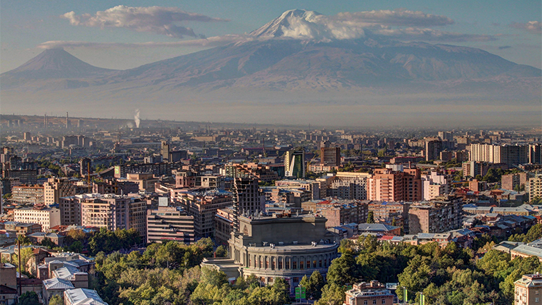
Projects ARMENIA PSHA MODELLING Probabilistic Seismic Hazard Assessment for the Republic of Armenia Versión en español English version Share Facebook LinkedIn Overview Anchor 6 Background This project responds to a World Bank request for a probabilistic seismic hazard assessment for the Republic of Armenia. The goal of this study is to better understand the existing seismic hazard information in the country, and to provide an updated hazard model. The GEM Hazard Team supports all aspects of the model development, and in the running of the analyses with the OpenQuake engine. Duration: 2017 Objectives Probabilistic seismic hazard models, such as this model for the Republic of Armenia, can be used as a rigorous and robust basis for the design of a national disaster risk financing and insurance strategy. Collaborators Verisk (AIR Worldwide), GEM Foundation, Georisk Scientific Research Company Funding partner: World Bank Group Location Armenia Anchor 1 Anchor 5 Anchor 4 Anchor3 Publications
- GFDRR-DFID | Global Earthquake Model Foundation
Projects GFDRR-DFID GFDRR-DFID Challenge Funds Versión en español English version Share Facebook LinkedIn Overview Anchor 6 Background The Global Facility for Disaster Reduction and Recovery (GFDRR) and the UK Department for International Development's (DFID) competitive Challenge Fund pilots new and innovative approaches to overcoming technical and technological challenges in order to strengthen disaster and climate risk decision-making in developing countries. To this end, this project is supporting the development of data, products, and approaches to support disaster risk management decision-making and build resilience, including through better information, but also strengthening key steps in moving from information to insight and behaviour change. Each challenge is focusing on the development of a database with hazard footprints, exposure information and vulnerability models. The viability of the databases will be demonstrated using exposure data for Tanzania and another DFID priority country. Objectives The project is divided into three components. The British Geological Survey leads the development of a data schema and data for a multi-hazard database (Challenge 1) while GEM and University College London lead the development of a global exposure database (Challenge 2) and open vulnerability platform for evaluating risk (Challenge 3) respectively. GEM also contributes to Challenge Fund 1 and 3. GEM leads Challenge Fund 2 on the development of a global exposure data framework, which includes the physical vulnerability characteristics and exposure taxonomy. The aim is to identify the most important vulnerability characteristics; ways to account for uncertainties in exposure and vulnerability models; type of assets that should be supported by the vulnerability and exposure database; and the most common and useful intensity measure types. The objective of this project is to develop a Data Exploration Tool to promote the ability of a user to access, understand and use hazard, exposure and vulnerability data stored in a format that follows the data schema developed by the Challenge Fund consortia. British Geological Survey (BGS) leads the development of a data schema and data for a multi-hazard database (Challenge 1) GEM Foundation leads the development of a global exposure database (Challenge 2) University College London (UCL) leads the development of open vulnerability platform for evaluating risk (Challenge 3) Various organizations also participated and contributed to the project such as the Geological Survey of Tanzania; Ardhi University (Tanzania); Dar Es Salaam University (Tanzania); DFID Tanzania; Prime Minister's Office - Disaster Management Department (Tanzania); DoMA (Malawi); INGC (Mozambique); Ministry of Energy & Mineral Development (Uganda); ImageCat (USA); Humanitarian OpenStreetMap Team (HOT Indonesia); NSET (Nepal); IDF (Switzerland); UA (Netherlands); NGI (Norway); NOC (UK); CIMA (Italy); and UCL-EPI (UK). Locations Tanzania and neighbouring countries Anchor 1 Anchor 5 Anchor 4 A consortium led by the GEM Foundation with partners ImageCat Inc. and the Humanitarian OpenStreetMap Team completed recently an open exposure database for multi-hazard risk assessment... The University College London (UCL) EPICentre and CatLin XL hosted the second workshop held on July 27 in London to collect feedback. The GFDRR-DFID Challenge Fund projects on the development of exposure, vulnerability and hazard footprints databases kicked off with a 2-day inception workshop. Anchor3 Publications GFDRR-DFID Challenge Funds Round 2 How can innovative approaches make communities more resilient to climate change and natural disasters? GFDRR-UK Aid Challenge Fund: Final Learning Report: Value of Risk Information for Decision Making May 31, 2018 Data schema and data: for multi-hazard database (BGS), for global exposure database (GEM), for a global database of vulnerability functions (UCL) Extensible Data Schemas for Multiple Hazards, Exposure and Vulnerability Data published as part of the UNDRR GAR2019 .
- INDONESIA DRR | Global Earthquake Model Foundation
Projects INDONESIA DRR Seismic Resilience Baseline Analysis and Investment Option Needs in Indonesia Versión en español English version Share Facebook LinkedIn Overview Anchor 6 Background This project, funded by the World Bank's GFDRR, aims to conduct a seismic baseline analysis to support the development of a potential national seismic risk mitigation program in Indonesia. The study focuses on public assets, which include education facilities (primary and secondary schools, universities), health facilities (health clinics, hospitals), commercial facilities (shophouse), emergency services facilities (e.g., ambulance stations, fire stations, early warning service providers), and critical government administration buildings (e.g., local disaster management offices). The project has five main tasks: 1. Inception: literature review on seismic risk in Indonesia, methodology, definition of stakeholder/consultation workshops, preliminary data collection 2. Baseline analysis of Indonesia’s exposure and vulnerabilities to seismic hazards (earthquakes and tsunami) 3. Seismic Risk Assessment and Rapid Prioritization of Potential Investments in Three Selected Districts 4. Development of Baseline Data and Conceptual Framework Design 5. Final Report and Completion Report The GEM Risk Team contributes to all tasks, ranging from support on hazard modelling, development of exposure, selection of vulnerbaility models and the computation of seismic risk using the OpenQuake engine. Duration: 2022-2023 Objectives The methodology, workplan, programme and potential target cities is elaborated together with the World Bank and Indonesian Ministry of Public Works and Housing (MPWH) stakeholders and other relevant agencies such as Ministry of National Development Planning (Bappenas), National Disaster Management Authority (BNPB), Ministry of Home Affairs (MoHA) and Agency for Meteorology, Climatology and Geophysics (BMKG). The objectives include: (a) a rapid baseline analysis of the exposure and vulnerability of the country and three Indonesian districts to earthquakes and tsunami, baseline information/data, and gap analysis, including disaggregated analysis of risk and vulnerability of women and other vulnerable groups; (b) a conceptual framework for improving seismic resilience and recommendations for a national program that aims to reduce the vulnerability of people (with consideration for diverse groups) and assets to earthquakes and tsunami through an integrated package of structural and non-structural investments; and (c) stakeholder consultations to seek inputs on the potential program design, investment funding mechanisms, and institutional set-up options for the national program. Collaborators GEM Foundation, Arup, LAPI-ITB and Kota Kita Funding partner: World Bank GFDRR Locations Three cities in Indonesia: ‣ Kota Bengkulu, Bengkulu province ‣ Kota Cilegon, Banten province ‣ Kota Gorontalo, Gorontalo province Anchor 1 Anchor 5 Anchor 4 Anchor3 Publications
- ARMENIA POST DRR | Global Earthquake Model Foundation
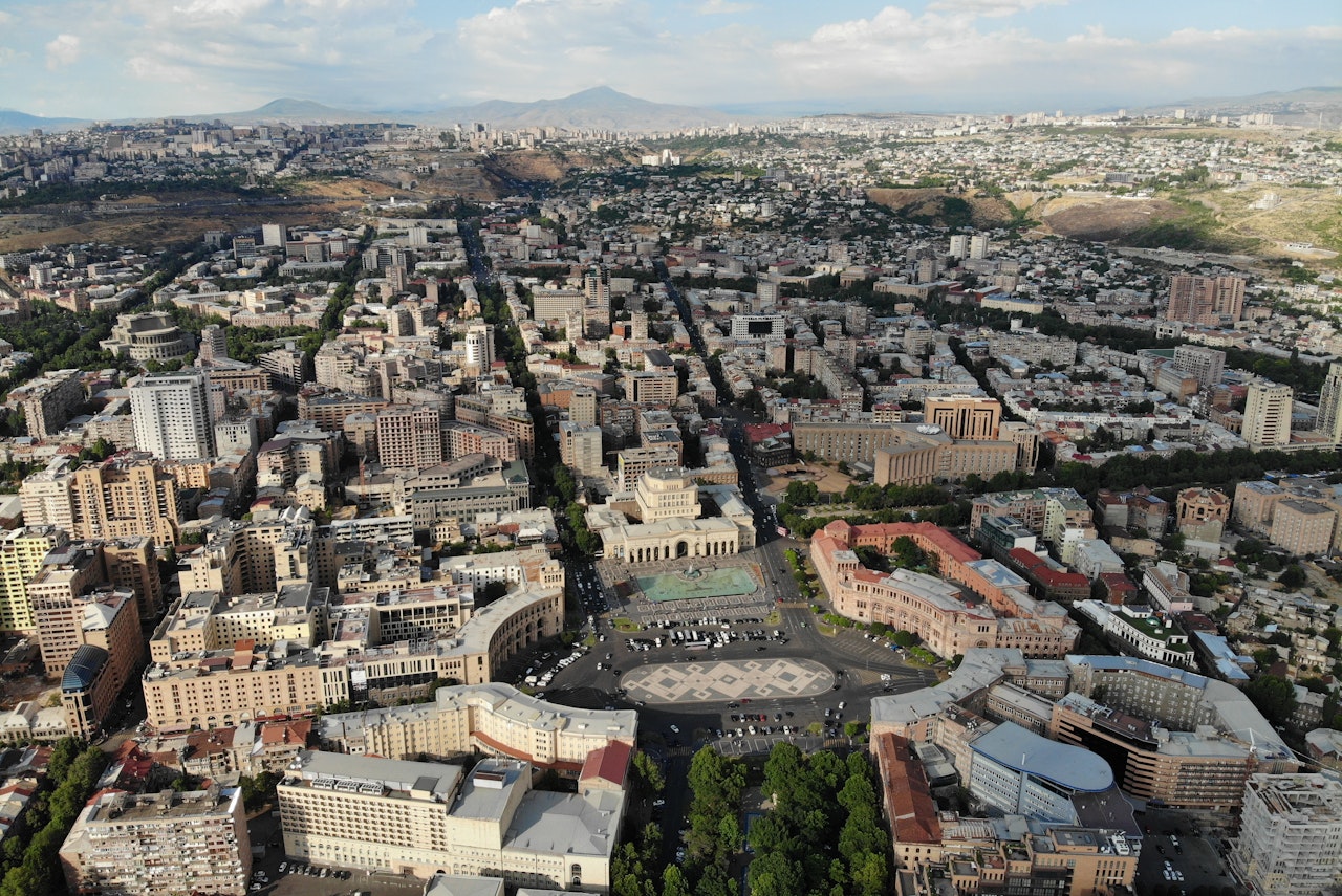
Projects ARMENIA POST DRR Improving Post-Disaster Damage Data Collection to Inform Decision Making Versión en español English version Share Facebook LinkedIn Overview Anchor 6 Background This project, responding to a request from the World Bank for improved post-disaster damage collection, focuses on the collection of data on physical damage to assets such as buildings (residential, commercial, industrial, public), infrastructure, and crops. The aim is to evaluate the current state-of-the-art in post-disaster damage collection – in protocols, tools and systems – in order to identify a suitable protocol and toolset that could be adopted by the Government of Armenia that would be generalisable and available, allowing adoption by other national government agencies or interested parties. The GEM Foundation leads the consortium working on this project, with the GEM Risk Team undertaking the following main tasks: Review of existing protocols, tools and systems Design of a conceptual protocol and toolset Application to the context of Armenia Recommendations Duration: 2018 Objectives Collection of damage data following major disaster events is a fundamental exercise for a multitude of purposes, such as emergency management, resource allocation, fund mobilization and reconstruction planning. The processes involved, and scales of damage assessments vary by country, peril and context. Numerous sector-specific data collection activities provide an estimation of damage, loss and post-disaster needs in order to provide relief and facilitate the commencement of reconstruction and recovery efforts. The project includes identifying and reviewing tools for collecting data in the field as well as damage data aggregation and reporting tools. Of particular interest is the use case in Armenia, demonstrating the needs of a Ministry of Finance requiring national-level reporting of damage on a sub-national level in a transparent system that allows the user to store, retrieve and interrogate damage data down to the asset-level. Collaborators GEM Foundation, JBA Consulting, CIMA Foundation and Geocom Ltd Funding partner: World Bank Group Location Armenia Anchor 1 Anchor 5 Anchor 4 Anchor3 Publications
- SERA Project | Global Earthquake Model Foundation
Projects SERA Project Seismology and Earthquake Engineering Research Infrastructure Alliance for Europe (SERA) Versión en español English version Share Facebook LinkedIn Overview Anchor 6 Background The Seismology and Earthquake Engineering Research Infrastructure Alliance for Europe (SERA) aims to reduce the risk posed by natural and anthropogenic earthquakes based on innovative research and development projects. SERA will significantly improve the access to data, services and research infrastructures for scientists and other professionals. GEM's contributions focus on taxonomy and exposure of residential, commercial and industrial buildings in Europe; physical vulnerability assessment for buildings; integrated earthquake risk analysis using the risk assessment framework and OpenQuake software established by the Global Earthquake Model. SERA is a Horizon 2020-supported programme responding to the priorities identified in the topic INFRAIA-01-2016-2017 ‘Integrating Activities for Advanced Communities’. SERA involves 31 partners and 8 linked third parties in Europe. It started in May 2017 and will last for three years. Objectives The EUCENTRE-SERA project is collaborating closely with the GEM Foundation (Global Earthquake Model) to: develop a European Risk Modelling framework that brings together the strengths of previous projects such as SHARE, NERA and fills in the research gaps; integrate knowledge and data from other SERA working packages; and build on the risk assessment framework and software developed by GEM. SERA is engaging 31 partners from 16 European countries. They all have leading expertise in the operation of experimental facilities, monitoring infrastructures, and data repositories in the fields of seismology, anthropogenic hazards or earthquake engineering. (complete list ) Location Europe Anchor 1 Anchor 5 Anchor 4 EM-SERA OpenQuake Training in Istanbul, Turkey SERA European Building Exposure Workshop: From European Hazard to Risk Anchor3 Publications
- SSAHARA Project | Global Earthquake Model Foundation
Projects SSAHARA Project Sub Saharan Hazard and Risk Assessment (SSAHARA) Versión en español English version Share Facebook LinkedIn Overview Outcomes Training Outreach Photos Publications Anchor 6 Background The East African Rift System (EARS) is the major active tectonic feature of the Sub-Saharan Africa (SSA) region. Although the seismicity level of such a divergent plate boundary can be described as moderate, several damaging earthquakes have been reported in historical times, and the seismic risk is exacerbated by the high vulnerability of the local buildings and structures. Formulation and enforcement of national seismic codes is therefore an essential risk mitigation strategy. A reliable risk assessment must be based on an updated and reliable seismic hazard model for the region. The last published regional model for SSA was developed within the frame of the GSHAP project and is almost 20 years old (Midzi et al., 1999). The availability of new data, local and regional seismotectonic studies and recently developed methods and tools prompt the development of a new PSHA model summarizing the current state of knowledge in Sub-Saharan Africa. Objectives In September 2014, the United States Agency for International Development (USAID) GEM funding support to implement a program entitled “Reducing Earthquake Risk collaboratively by Building Capacity and Leveraging GEM’s Open Tools and Resources”. One of the objectives of this program was: to build the capacity in sub-Saharan Africa for integrated risk assessment and development of city earthquake scenarios involving local decision-makers. The project produced the SSA-GEM homogenized catalogue; the Seismic Source Zones; the Probabilistic Hazard Calculations; the Strain Rate Model; earthquake risk in East Sub-Saharan Africa; the residential building stock; and the Social Vulnerability and Integrated Risk in Sub Sahara Africa. Collaborators The development of a regional model would not have been possible without the contribution of experts from the local scientific community. Partnership with local governmental institutions and authorities was an essential step to facilitate model acceptance and for potential integration with national seismic codes. GEM worked with the following institutions for the implementation of the SSAHARA project. African Union; AfricaArray; FEPRA – Ethiopia; University of Pennsylvania; Addis Ababa City Government; UNDP Regional Office; and international agencies, municipalities and government agencies Location Burundi, Ethiopia, Kenya, Malawi, Mozambique, Rwanda, Tanzania, Uganda Website SSAHARA wiki website containing technical descriptions and overview of the project. Anchor 1 Anchor 5 Anchor 4 News Preventionweb article on the release of the Africa Model developed as part of the Sub-Sahara Hazard and Risk Assessment (SSAHARA) project funded by USAID. Anchor3 Publications Disclaimer The contents of this project website such as studies, reports, audio-visual, news articles, blogs, and other information or media products including those in the external links are made possible by the generous support of the American people through the United States Agency for International Development (USAID). The contents are the responsibility of the Global Earthquake Model (GEM) Foundation and do not necessarily reflect the views of USAID or the United States Government.
- TREQ Project | Global Earthquake Model Foundation
Projects TREQ Project Training and Communication for Earthquake Risk Assessment (TREQ) Versión en español English version Share Facebook LinkedIn Overview Risk Assessment Training Outreach Photos Publications Anchor 6 Summary The Training and Communication for Earthquake Risk Assessment (TREQ) Project was designed to demonstrate how earthquake hazard and risk assessment can inform decision makers in the development of risk reduction policies, as well as how earthquake risk can be properly communicated to stakeholders and the public in general. [PDF Executive Summary English ] Objectives The project was organized into two main parts. The first one aimed to develop capacity for urban earthquake hazard and risk assessment in Latin America, Quito (Ecuador), Cali (Colombia), and Santiago de los Caballeros (Dominican Republic); while the second part was to develop training, educational and communication material to enhance the understanding of earthquake risk worldwide. The program was tailored for a wide spectrum of stakeholders, categorized into four main groups: governance (decision-makers/public authorities), industry (practitioners and professionals), academia (researchers and professors), and the community. Collaborators Ecuador Municipalidad de Quito Escuela Politécnica Nacional (EPN) Instituto Geofísico (IG) Colegio de Ingenieros Civiles de Pichincha (CICP) Pontificia Universidad Católica del Ecuador Dominican Republic Municipalidad de Santiago de los Caballeros Servicio Geológico Nacional (SGN) Oficina Nacional de Evaluación Sísmica y Vulnerabilidad de Infraestructuras y Edificaciones (ONESVIE) Comité Técnico Nacional (CTN) Pontificia Universidad Católica Madre y Maestra (PUCMM) Colombia Municipalidad de Santiago de Cali Servicio Geológico Colombiano (SGC) Departamento Administrativo de Planeación Municipal (DAPM), Cali Universidad EAFIT, Medellin Unidad Nacional de Gestión del Riesgo de Desastres (UNGRD) Costa Rica Universidad de Costa Rica (UCR) Mexico Universidad Autónoma de Baja California (UABC) Location Quito (Ecuador), Cali (Colombia), and Santiago de los Caballeros (Dominican Republic) Urban risk assessment in Latin America and the Caribbean The following deliverables were generated in this component: seismic hazard and risk assessment at the urban scale for the three TREQ cities: Quito (Ecuador), Cali (Colombia), and Santiago de los Caballeros (Dominican Republic). State-of-art models were developed for each city in close collaboration with local partners. The input models and results are available at the URL address below: [github.com/gem/treq-riesgo-urbano/ ] a. City reports Seismic Risk Assessment for the Metropolitan District of Quito [Evaluación de Riesgo Sísmico para el Distrito Metropolitano de Quito] [Español ] Seismic Risk Assessment for Santiago de Cali [Evaluación de Riesgo Sísmico para Santiago de Cali] [Español ] Seismic Risk Assessment for Santiago de los Caballeros [Evaluación de Riesgo Sísmico para Santiago de los Caballeros] [Español ] b. Seismic Hazard Assessment PSHA models and datasets for urban hazard assessment [Modelos probabilísticos de amenaza sísmica (PSHA) y conjuntos de datos para la evaluación de la amenaza a nivel urbano] [PDF English ] Probabilistic seismic hazard model for the Dominican Republic [Modelo Probabilístico de Amenaza Sísmica para la República Dominicana] [PDF English | Español ] [Download Model ] Seismic hazard results (rock and soil conditions) [Resultados de amenaza sísmica (condiciones en roca y en suelo)] [PDF English ] Seismic hazard analysis at the urban scale [Análisis de la amenaza sísmica a escala urbana] [PDF English ] c. Seismic Risk Assessment Executive summary Urban seismic risk assessment for the cities of Quito, Cali and Santiago de los Caballeros [Resumen ejecutivo sobre la evaluación del riesgo sísmico urbano para las ciudades de Quito, Cali y Santiago de los Caballeros] [PDF English ] Building classes in Quito, Cali and Santiago de los Caballeros [Tipologías constructivas en Quito, Cali and Santiago de los Caballeros] [PDF Español ] Geo-referenced exposure database of population and buildings in the TREQ city [Base de datos de exposición georreferenciada de población y edificios en cada ciudad de TREQ] [Cali ] [Quito ] [Santiago ] Database of fragility and vulnerability functions for each building class present in the exposure model [Base de datos de funciones de fragilidad y vulnerabilidad para cada clase de edificio presente en el modelo de exposición] [Data ] Maps and risk metrics generated for each city [Mapas y métricas de riesgo para cada ciudad] [Cali ] [Quito ] [Santiago ] d. City scenarios Database with ruptures selected for scenario analysis [Base de datos con rupturas seleccionadas para análisis de escenarios] [Cali ] [Quito ] [Santiago ] Scenario hazard assessment for the representative earthquakes in Quito, Cali and Santiago de los Caballeros [Evaluación del escenarios de amenaza para sismos representativos en Quito, Cali y Santiago de los Caballeros] [PDF English ] e. Urban Applications Earthquake induced landslides and liquefaction in Cali [Deslizamientos y licuefacción inducidos por sismo en Cali] [PDF English ] Anchor 1 Anchor 5 Improving global capacity for seismic hazard and risk This part of the program was designed to improve the understanding and awareness of earthquake hazard and risk, and to help bridge the gap between the information produced in detailed hazard and risk assessment studies and its communication to a wide variety of stakeholders (which range from local experts with the remit to assess seismic risk to decision-makers responsible for the implementation of risk reduction measures). a. Website for OpenQuake online training The OpenQuake online training was designed for different types of audience with diverse background and expertise. Through this platform, participants interacted with GEM scientific and technical teams to learn the main concepts of earthquake risk assessment, along with the basic features of the engine. [English | Español ] b. OpenQuake manual in online format The official manual has been converted from latex into reStructuredText format made possible by @USAID support. The new manual is now online in HTML format and can be accessed at: [Webpage English ] c. Video tutorials on seismic hazard and risk analysis using OpenQuake The project has produced 15 videos on technical training using the OpenQuake-engine (in English and Spanish), 7 videos with material to disseminate the models and results of urban risk assessment in the TREQ cities, and 2 videos for communicating earthquake risk to the general public. OQ Engine Video Tutorials [ English | Español ] d. Manual to perform seismic hazard analysis This manual presents the basic concepts of classical PSHA and the wide spectrum of alternatives to model seismicity and uncertainties (epistemic and aleatory) in the OpenQuake-engine. Probabilistic Seismic Hazard Assessment (PSHA) is the principal methodology for assessing the potential hazard posed by earthquakes. The hazard maps generated with the hazard calculator are widely used in national seismic codes for hazard zonation and structural design provisions. [PDF English ] [Example materials ] [More info ] e. Training the Trainers TREQ has engaged and collaborated with five university professors from Latin America to conceptualize, create and implement a unified course for the study of seismic risk at the university level. Brochures in English and Spanish further explain the concept behind this initiative and outline the early results and experiences of the professors from Colombia, Costa Rica, El Salvador, Guatemala and Mexico. [PDF English | Español ] Anchor 4 Communicating and raising earthquake risk awareness The activities in this component focused on raising awareness of the public on earthquake hazard and risk by training a diverse group of disaster risk reduction (DRR) professionals together with personnel in charge of communicating risk to the public, and by conducting community-based workshops in selected areas of the pilot cities by those who were trained by the project. a. Educational material to raise seismic risk awareness: Application for the Metropolitan Area of Aburra Valley (AMVA) [Material didáctico para sensibilizar a la comunidad sobre el riesgo sísmico: Aplicación para el área Metropolitana del Valle de Aburrá (AMVA)] [PDF Español ] b. Video to communicate earthquake risk to the general public [Video para comunicar el riesgo de terremoto al público en general] [English | Español ] c. Guidelines for teachers for the development of an introductory course on seismic risk [Guía para profesores para el desarrollo de un curso introductorio de riesgo sísmico] [PDF Español ] d. Urban risk mitigation and response profiles for the TREQ cities [Perfiles de respuesta y mitigación de riesgos urbanos para las ciudades TREQ] [Cali ] [Quito ] [Santiago ] News articles Events Understanding seismic risk through capacity development and knowledge sharing webinar draws hundreds of participants from around the world [Article ] [Event page English | Español ] [Video ] Presentation of the national PSHA model for the Dominican Republic: a joint webinar hosted by Servicio Geológico Nacional Dominicano in cooperation with GEM, Oficina Nacional de Evaluación Sísmica y Vulnerabilidad de Infraestructura. and USAID's Bureau for Humanitarian Assistance . [Event flyer Español ] [Video English | Español ] ---- Articles Raising Earthquake Risk Awareness: TREQ’s community workshops for the general public Urban hazard assessment of selected cities in Latin America Local solutions to global problems: reducing disaster risk through collaboration and openness TREQ Project Updates: Site Effects Modelling and Urban Exposure Models USGS has joined the TREQ initiative for urban earthquake scenarios TREQ capacity building: OQ online training updates Jan-Feb 2021 TREQ2020 – Capacity development and OpenQuake online training, year in review TREQ OpenQuake Online Training: Earthquake Scenarios - Ground Motion Fields Sept 2020 More at GEM News section Newsletter The TREQ project newsletter was intented to share activities in urban risk assessment, and earthquake risk training and education materials with a wide-range of local stakeholders from the academia, private and public sectors, as well as the civil society in Latin America, the Caribbean and beyond. Newsletter no. 3 - May 2021 Newsletter no. 2 - September 2020 Newsletter no. 1 - March 2020 Maiden issue [English ] Maiden issue [Españo ] Anchor3 BUSINESS NEWS More TREQ photos here Facebook album 1/4 BUSINESS NEWS Raising Risk Awareness: workshops for the general public 1/4 BUSINESS NEWS March 2020 Project Kickoff 1/4 BUSINESS NEWS Photos from the November 2020 OpenQuake Online training 1/2 BUSINESS NEWS Meetings in Quito 1/10 BUSINESS NEWS Meetings in Guayaquil 1/1 Publications Overview TREQ Executive Summary [English ] Seismic Hazard Assessment PSHA models and datasets for urban hazard assessment [English ] Probabilistic seismic hazard model for the Dominican Republic [English | Español ] [Download Model ] Seismic Hazard Results (rock and soil conditions) [English ] Seismic hazard analysis at the urban scale [English ] Seismic Risk Assessment Executive summary Urban seismic risk assessment for the cities of Quito, Cali and Santiago de los Caballeros [English ] Building classes in Quito, Cali and Santiago de los Caballeros [Español ] City Scenarios Scenario selection for representative earthquakes in Quito, Cali and Santiago de los Caballeros [English ] Urban applications Earthquake-induced liquefaction and landslides in Cali, Colombia [English ] City reports Seismic Risk Assessment for the Metropolitan District of Quito [Español ] Seismic Risk Assessment for Santiago de Cali [Español ] Seismic Risk Assessment for Santiago de los Caballeros [Español ] Training and communicating earthquake risk Probabilistic Seismic Hazard Analysis (PSHA) Training Manual [English ] [Example materials ] [More info ] Educational material to raise seismic risk awareness: Application for the Metropolitan Area of Aburra Valley (AMVA) [Español ] Guidelines for teachers for the development of an introductory course on seismic risk [Español ] Disclaimer The contents of this project website such as studies, reports, audio-visual, news articles, blogs, and other information or media products including those in the external links are made possible by the generous support of the American people through the United States Agency for International Development (USAID). The contents are the responsibility of the Global Earthquake Model (GEM) Foundation and do not necessarily reflect the views of USAID or the United States Government.
- MALAWI MULTI-HAZARD | Global Earthquake Model Foundation
Projects MALAWI MULTI-HAZARD Comprehensive Multi hazard Risk Assessment in Malawi Versión en español English version Share Facebook LinkedIn Overview Outcomes Training Outreach Photos Publications Anchor 6 Background Malawi is a country strongly affected by the impact of extreme events, exacerbated by rapid population growth and urbanisation. A multi-risk assessment is currently lacking at the national level, while it is available only at the local level in some districts. Therefore, the project consortium intends to produce, for the first time, hazard and risk maps on a national level with a level of detail useful also at provincial level, using a probabilistic risk assessment approach, both for single hazards and for multi-hazard conditions (i.e. extreme winds and precipitation, earthquakes, landslides, river floods). The GEM Risk Team is reponsible for the seismic risk assessment, comprising the modelling of the hazard, exposure and vulnerability components and the calculations of seismic risk in the OpenQuake engine. Duration: 2023-2024 Objectives In line with the guidelines of the Sendai Framework for Disaster Risk Reduction, the multi-hazard probabilistic assessment carried out within the project provides risk estimates for both the most probable and frequent events, as well as for rare ones; at the same time, it allows for the analysis of events that have never been observed but may occur in the future, which is of particular importance considering the uncertainty caused by climate change. The assessment will therefore consider risks under current climate conditions as well as future conditions (2050-2100) under different climate change scenarios. For the realisation of the multi-risk assessment, the project partners will work closely with local stakeholders at all stages of the development, from data collection to the creation of the Risk Atlas and the Risk Information Web Platform, two tools that will collect information from the assessment and will make it easier to communicate and understand, thus following a capacity development approach that combines knowledge development with knowledge transfer. In addition, the partners will develop, again in collaboration with local stakeholders, a sustainability plan containing recommendations for maintaining and updating risk information, supporting the management, updating and accessibility of Malawi’s risk information by national and local authorities. Collaborators GEM Foundation, Centro Internazionale in Monitoraggio Ambientale (CIMA), Malawi University of Business and Applied Sciences (MUBAS), British Geological Survey (BGS) Funding partner: World Bank Group Location Malawi Aiming to empower Malawi with a comprehensive understanding of disaster risks, the project will deliver the following key outputs: Comprehensive Hazard Identification and Assessment: A national-level assessment of various hazards in Malawi, including floods, droughts, landslides, earthquakes, and strong winds. Exposure Mapping: Creation of maps outlining the extent to which people, infrastructure, buildings, and agriculture are exposed to each hazard. Vulnerability Assessment: Evaluation of the physical (infrastructure, buildings) and social (poverty, access to resources) vulnerabilities of Malawian communities to these hazards. National Hazard and Risk Profiles: Development of comprehensive national profiles that detail the hazards, their potential impacts, and the level of risk faced by different regions and communities. Knowledge and Technology Transfer: Training and capacity building for Disaster Risk Reduction (DRR) practitioners and academic institutions in Malawi on using the multi-hazard risk assessment data and tools. Anchor 1 Anchor 5 Platform deployment, knowledge transfer, maintenance and ownership This project builds a long-term plan for Malawian experts to manage the multi-hazard risk atlas database. Through trainings and knowledge transfer, local technicians will become self-sufficient in maintaining the system and training future users. This ensures the platform's sustainability and empowers Malawian authorities to fully utilize the risk information for informed decision-making. a. Hands-on training on the Risk Atlas Database Training of the Department of Disaster Management Affairs (DODMA) ICT team to install and utilise the Risk Atlas Database held in Salima, Malawi, from June 3-7, 2024. b. Exposure and Vulnerability Data The exposure and vulnerability work was delivered to the client and presented in a dedicated training session in November 2023. Anchor 4 GEM Contributes to Multi-Hazard Risk Assessment Progress in Malawi The Global Earthquake Model (GEM) Foundation actively participated in a Multi-Hazard Risk Assessment workshop held in Salima, Malawi, from June 3-7, 2024. This collaborative effort involved the Department of Disaster Management Affairs (DODMA) as the host, alongside the International Centre for Environmental Monitoring (CIMA Research Foundation), Malawi University of Business and Applied Sciences (MUBAS), and the British Geological Survey (BGS). Read more Anchor3 BUSINESS NEWS Multi-Hazard Risk Assessment workshop held in Salima, Malawi, from June 3-7, 2024 1/6 Publications
- PERU PUBLIC SCHOOLS | Global Earthquake Model Foundation
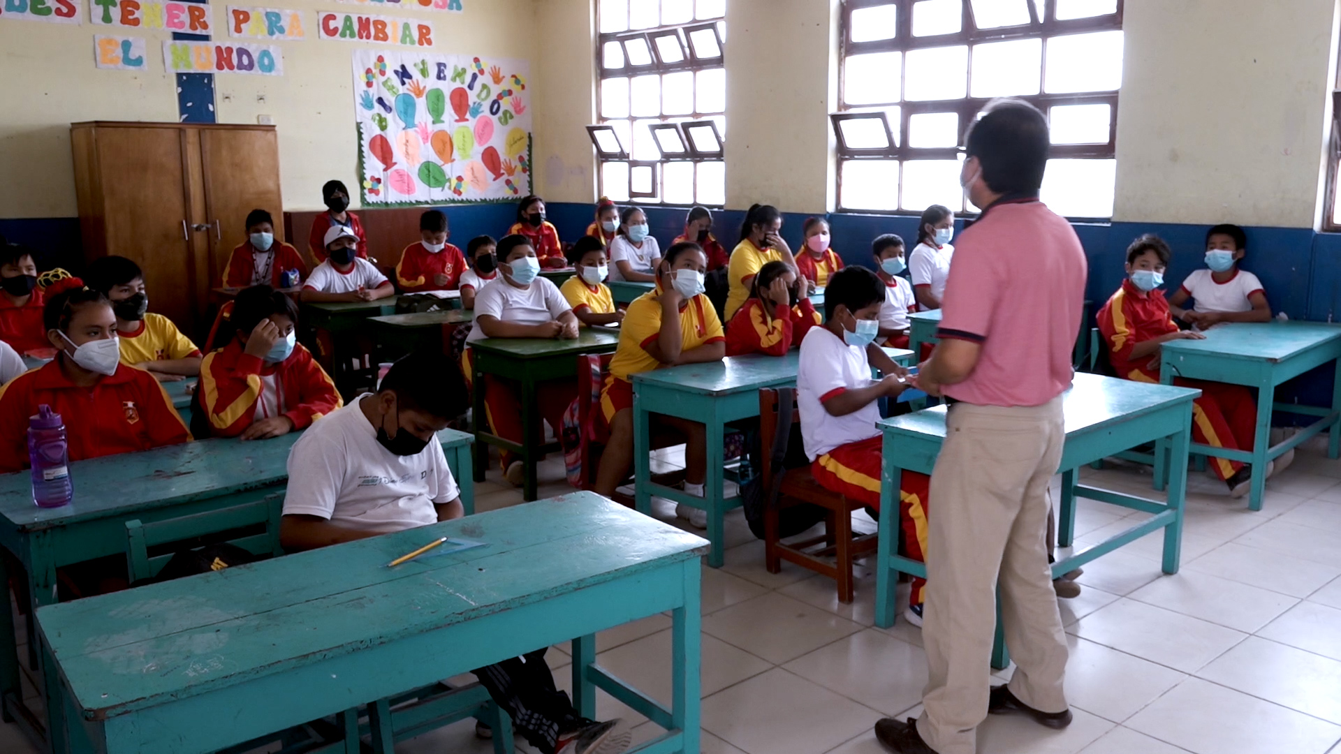
Projects PERU PUBLIC SCHOOLS Development of an Insurance Program for Peru’s Public Schools Versión en español English version Share Facebook LinkedIn Overview Anchor 6 Background The project aims to protect more than 50,000 public schools in Peru against the impact of natural hazards, and to improve continuity for children’s education by accelerating reconstruction and strengthening the country’s resilience through an innovative insurance programme. The GEM Hazard and Risk Teams are contributing to the design of the insurance programme with expertise in the earthquake hazard and risk modelling of school buildings in Peru. For more information, visit https://www.bmz.de/en/issues/climate-change-and-development/climate-risk-insurance/59532-59532. Duration: 2020 - 2024 Objectives The main objective of this project is to design an insurance programme for Peru’s public schools. The project will provide the Government of Peru with options to cover all or a subset of its more than 50,000 public schools against the impact of natural hazards thus accelerating reconstruction, while also strengthening the country’s resilience. Collaborators GEM Foundation, AXA XL, Munich Re, Peruvian Association of Insurance Companies (APESEG), JBA Risk Management, InsurTech Picsure. Funding partner: Germany’s InsuResilience Solutions Fund (ISF) Location Peru Anchor 1 Anchor 5 Anchor 4 Anchor3 Publications
- GEORGIA DRR | Global Earthquake Model Foundation
Projects GEORGIA DRR Capacity building to understand and take action on seismic risks in Georgia Versión en español English version Share Facebook LinkedIn Overview Anchor 6 Background This project aims to enhance the understanding of earthquake impacts in Georgia and to address the following two challenges: i. The lack of understanding of potential earthquake risk and the impact on people, infrastructure and the economy at large; and ii. the lack of efforts to reduce the vulnerability of existing infrastructure, particularly critical emergency response infrastructure. The project is divided into 5 tasks, with the GEM Risk Team contributing to all tasks, with a specific emphasis on developing exposure models, identifying vulnerability models and running the probabilistic seismic risk assessment with the OpenQuake engine: Task 1 – Project Inception Task 2 – Preparation of Input Data & Development of Input Models Task 3 – Seismic Risk Analysis Task 4 – Recommendations on Risk Reduction Strategy Task 5 – Capacity Building Workshops Duration: 2020-2021 Objectives The objective of this project is to provide greater insight to the World Bank into the exposure of Georgia’s emergency response sectors to earthquakes and the potential consequences, as well as strategies to build seismic resilience in these sectors. The findings allow the World Bank to develop recommendations and better advise the Government of Georgia on how to: i. enhance its capacity to plan for future risk reduction investment programs based on a better understanding of earthquake risk in emergency response buildings; ii. develop options for a framework for a future short, medium and long-term intervention strategy; and iii. communicate and build consensus on earthquake risks and potential interventions in key sectors. Collaborators GEM Foundation, Arup, Progress Project LLC, Ilia State University Funding partner: World Bank Group Location Georgia Anchor 1 Anchor 5 Anchor 4 Anchor3 Publications