Thanks for submitting!
You will be contacted as soon as possible


QUICK LINKS


PROFILES
PUBLICATIONS
EXPOSURE
VULNERABILTY
SOFTWARE
EQ MODELS
Search Results
1079 results found with an empty search
- Estimating Road Disruptions in Urban Contexts Due to Earthquakes Using Machine Learning Surrogates | GEM Foundation
Publications Estimating Road Disruptions in Urban Contexts Due to Earthquakes Using Machine Learning Surrogates Share Facebook LinkedIn Download 2025 | Peer-reviewed The estimation of road disruptions due to building debris in urban contexts requires the availability of exposure data at the building level, which is often not available. In this study, we explore how open global datasets at different scales can be integrated with machine learning algorithms to estimate road disruptions following seismic events, overcoming the need for detailed datasets. Using simulated impact data for the municipality of Lisbon, we train a Random Forest model to predict road disruptions due to building collapses. Then, we apply this model to another urban environment (the municipality of Amadora) to evaluate the performance of the model using input data unseen during the training process. Finally, we employ the surrogate model using information extracted from globally available datasets characterizing the built environment and the road network. The proposed approach allows identifying areas within urban centers where road disruptions are likely to occur, and where risk reduction measures should be prioritized to minimize the impact of destructive earthquakes.
- Significant Seismic Risk Potential From Buried Faults Beneath Almaty City, Kazakhstan, Revealed From High-Resolution Satellite DEMs | GEM Foundation
Publications Significant Seismic Risk Potential From Buried Faults Beneath Almaty City, Kazakhstan, Revealed From High-Resolution Satellite DEMs Share Facebook LinkedIn Download 2021 | Peer-reviewed Major faults of the Tien Shan, Central Asia, have long repeat times, but fail in large (MwE 7+) earthquakes. In addition, there may be smaller, buried faults off the major faults which are not properly characterized or even recognized as active. These all pose hazard to cities along the mountain range front such as Almaty, Kazakhstan. Here, we explore the seismic hazard and risk for Almaty from specific earthquake scenarios. We run three historical-based earthquake scenarios (1887 Verny MwE 7.3, 1889 Chilik MwE 8.0 and 1911 Chon-Kemin MwE 8.0) on the current population and four hypothetical scenarios for near-field faulting. By making high-resolution Digital Elevation Models (DEMs) from SPOT and Pleiades stereo optical satellite imagery, we identify fault splays near and under Almaty. We assess the feasibility of using DEMs to estimate city building heights, aiming to better constrain future exposure datasets. Both Pleiades and SPOT-derived DEMs find accurate building heights of the majority of sampled buildings within error; Pleiades tri-stereo estimates 80% of 15 building heights within one sigma and has the smallest average percentage difference to field-measured heights (14%). A moderately sized MwE 6.5 earthquake rupture occurring on a blind thrust fault, under folding north of Almaty is the most damaging scenario explored here due to the modeled fault stretching under Almaty, with estimated 12,300E5,000 completely damaged buildings, 4,100 E 3,500 fatalities and an economic cost of 4,700 E 2,700 Million US dollars (one sigma uncertainty). This highlights the importance of characterizing location, extent, geometry, and activity of small faults beneath cities.
- Global building exposure model for earthquake risk assessment | GEM Foundation
Publications Global building exposure model for earthquake risk assessment Share Facebook LinkedIn Download 2023 | Peer-reviewed The global building exposure model is a mosaic of local and regional models with information regarding the residential, commercial, and industrial building stock at the smallest available administrative division of each country and includes details about the number of buildings, number of occupants, vulnerability characteristics, average built-up area, and average replacement cost. We aimed for a bottom-up approach at the global scale, using national statistics, socio-economic data, and local datasets. This model allows the identification of the most common types of construction worldwide, regions with large fractions of informal construction, and areas prone to earthquakes with a high concentration of population and building stock. The mosaic of exposure models presented herein can be used for the assessment of probabilistic seismic risk and earthquake scenarios. Information at the global, regional, and national levels is available through a public repository (https://github.com/gem/global_exposure_model), which will be used to maintain, update and improve the models.
- Probabilistic seismic hazard analysis for the Dominican Republic | GEM Foundation
Publications Probabilistic seismic hazard analysis for the Dominican Republic Share Facebook LinkedIn Download 2024 | Peer-reviewed The Dominican Republic experiences moderate to high seismic hazard mostly caused by oblique convergence at the Caribbean/North American plate boundary that manifests as subduction zones, less-pronounced subduction-like trenches with thrust faulting, long strike-slip faults parallel to the plate boundary, and onshore deformation. Historical earthquakes have damaged the Dominican Republic’s large cities and those in neighboring Haiti, once requiring relocation. Given this, the Dominican Republic joined the “Training and Communication for Earthquake Risk Assessment” (TREQ) project funded by the United States Agency for International Development, which aimed to increase earthquake risk assessment capacity in Latin American cities. The TREQ project was the basis for developing an openly available probabilistic seismic hazard model for the Dominican Republic. The input model was developed from two main datasets: a homogenized earthquake catalog and an active faults database that combines results of recent local projects with a global database. The seismic source characterization used these to constrain source geometries and occurrence rates for active shallow crustal earthquakes, subduction interfaces and subduction-like thrusts, and intraslab earthquakes. Shallow crustal earthquakes, including those on subduction-like thrusts, are modeled by smoothed seismicity and fault sources, the latter using pre-defined geometries that permit multi-fault ruptures. Seismicity on the Puerto Rico Trench subduction interface is modeled as a fault source, while intraslab sources use pre-defined gridded ruptures inside the intraslab volume. The source characterization applies epistemic uncertainties to modeling assumptions affecting occurrence rates and maximum magnitudes. The ground motion characterization used residual analyses from past regional projects as a basis, updating some components with more recent ground motion models. Computed hazard results reinforce those from recent studies in terms of geographical hazard patterns and levels. For 475-year return periods, peak ground acceleration (PGA) in Santiago de los Caballeros reaches 0.50 g, controlled by the Septentrional Fault, while all tectonic region types contribute to the PGA 0.31 g computed for Santo Domingo.
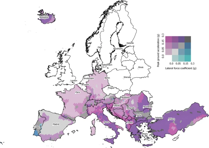
- Model of seismic design lateral force levels for the existing reinforced concrete European building stock | GEM Foundation
Publications Model of seismic design lateral force levels for the existing reinforced concrete European building stock Share Facebook LinkedIn Download 2021 | Peer-reviewed As part of the development of a European Seismic Risk Model 2020 (ESRM20), the spatial and temporal evolution of seismic design across Europe has been studied in order to better classify reinforced concrete buildings (which represent more than 30% of the approximately 145 million residential, commercial and industrial buildings in Europe) and map them to vulnerability models based on simulated seismic design. This paper summarises the model that has been developed to assign the years when different seismic design levels (low code, moderate code and high code) were introduced in a number of European countries and the associated lateral forces that were specified spatially within each country for the low and moderate codes for typical reinforced concrete mid-rise buildings. This process has led to an improved understanding of how design regulations evolved across Europe and how this has impacted the vulnerability of the European residential building stock. The model estimates that ~ 60% of the reinforced concrete buildings in Europe have been seismically designed, and of those buildings ~ 60% have been designed to low code, ~ 25% to moderate code and 15% to high code. This seismic design model aims at being a dynamic source of information that will be continuously updated with additional feedback from local experts and datasets. To this end, all of the data has been made openly available as shapefiles on a GitLab repository.
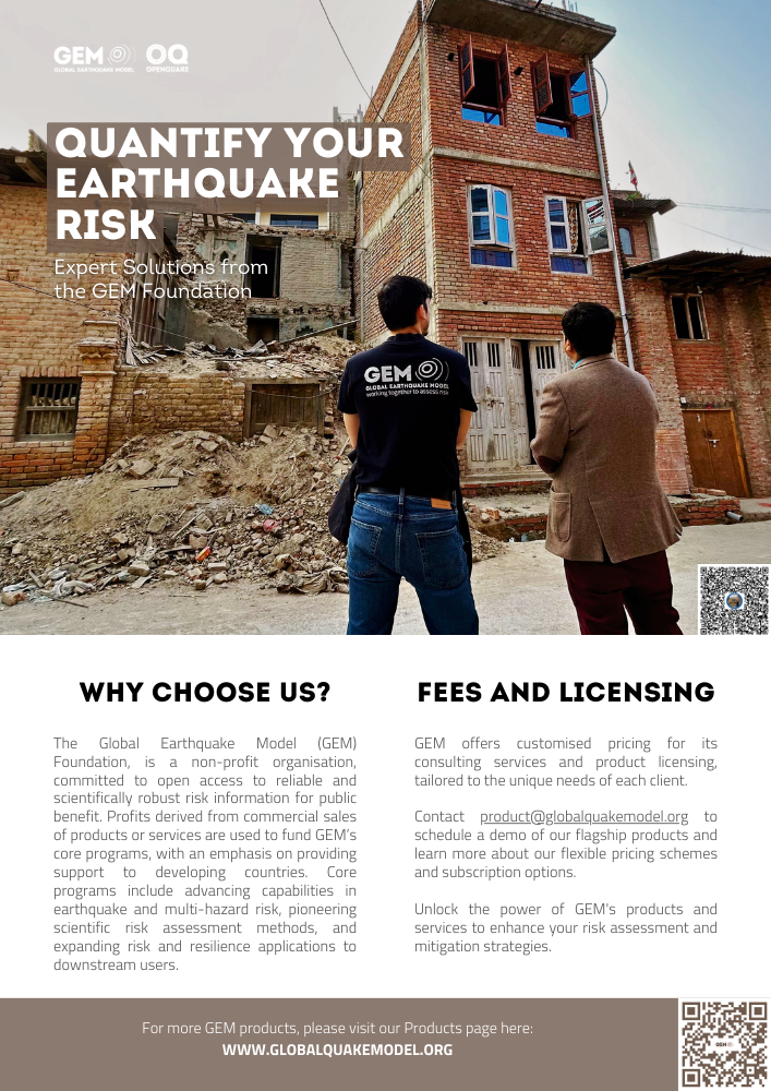
- Quantify Your Earthquake Risk: Expert Solutions from the GEM Foundation | GEM Foundation
Publications Quantify Your Earthquake Risk: Expert Solutions from the GEM Foundation Share Facebook LinkedIn Download 2024 | Brochure A quick glance of GEM's commercially available scientifically robust risk information and flagship products. The brochure also highlights GEM's collaborative projects globally for public good.
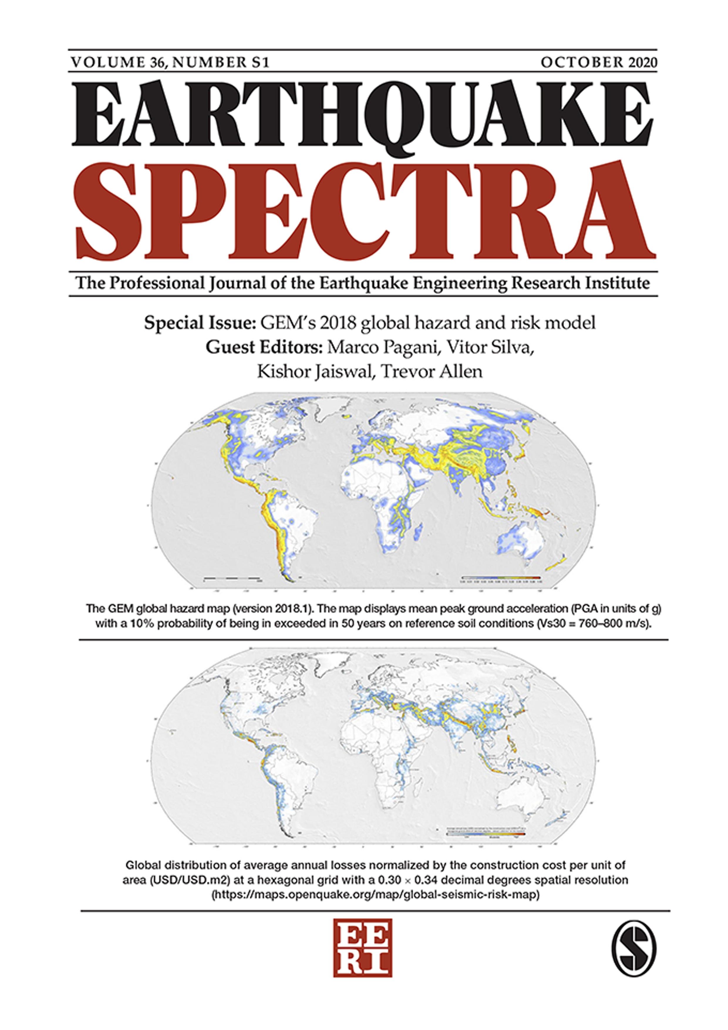
- GEM's 2018 global hazard and risk models | GEM Foundation
Publications GEM's 2018 global hazard and risk models Share Facebook LinkedIn Download 2020 | Peer-reviewed This special issue of Earthquake Spectra documents the supporting research critical to the development of the Global Seismic Hazard and Risk models by the GEM (Global Earthquake Model) Foundation, representing a major step in understanding earthquake risk globally. Seismic hazard and risk models are needed for accurate assessment of risks in order to promote risk reduction and mitigating actions, such as the improvement of building codes and construction practices, sustainable land use, emergency response, and protection of critical infrastructures, as well as risk transfer through insurance. GEM’s Global Seismic Hazard Model comprises a mosaic of 30 probabilistic seismic hazard models. Using this collection of hazard models as input, GEM computed a Global Seismic Risk Model depicting the average Annual Economic Losses (AEL) caused by ground shaking on the residential, commercial, and industrial building stock. Additional results were successively compiled including global maps for different intensity measure types, soil conditions and return periods. This collection of papers is intended for scientists and researchers in the hazard and risk modeling sector, and risk professionals for application to disaster risk reduction around the globe. This issue is made possible with partial support by the Global Earthquake Model (GEM) Foundation. Founded in Pavia, Italy in 2009, GEM is a non-profit public-private partnership that drives global collaborative efforts to develop scientific and high-quality resources for transparent assessment of earthquake risk and to facilitate their application for risk management around the globe. Learn more at www.globalquakemodel.org.
- GEM IT Review 2010 | GEM Foundation
Publications GEM IT Review 2010 Share Facebook LinkedIn Download 2013 | Report The primary (IT) goal of GEM is to extend the scope, but not necessarily the state-of-the-art, of risk and hazard calculation, as related to earthquakes. In order to achieve this, we expect our IT architecture to be: • Open (Data, Source, Protocols, Standards, etc.) • Pluggable (Modular, Loosely-Coupled) • Dynamic (Fault-tolerant, Distributed, Constantly Updated)
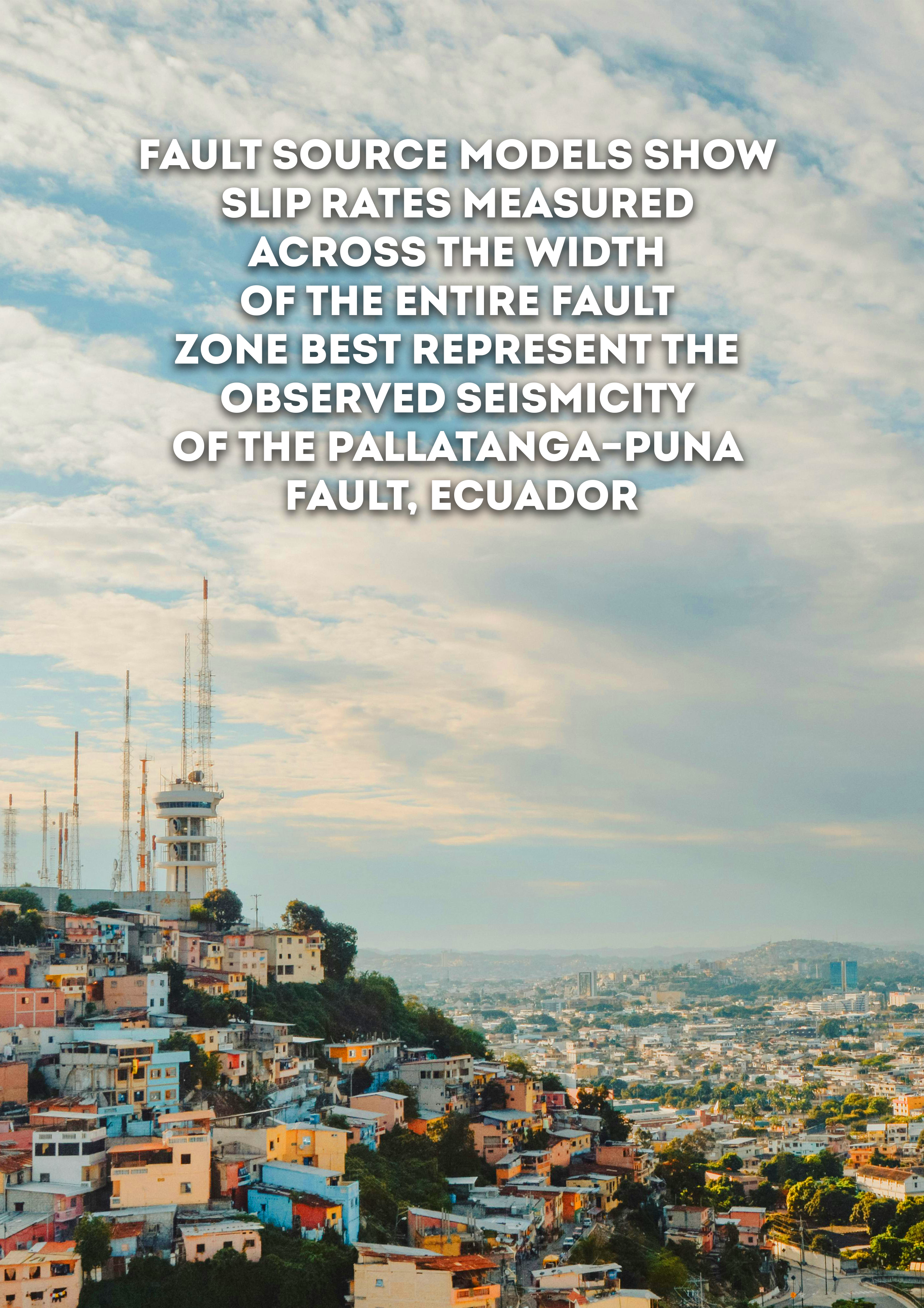
- Fault Source Models Show Slip Rates Measured across the Width of the Entire Fault Zone Best Represent the Observed Seismicity of the Pallatanga–Puna Fault, Ecuador | GEM Foundation
Publications Fault Source Models Show Slip Rates Measured across the Width of the Entire Fault Zone Best Represent the Observed Seismicity of the Pallatanga–Puna Fault, Ecuador Share Facebook LinkedIn Download 2024 | Peer-reviewed We explore how variation of slip rates in fault source models affect computed earthquake rates of the Pallatanga–Puna fault system in Ecuador. Determining which slip rates best represent fault‐zone seismicity is vital for use in probabilistic seismic hazard assessment (PSHA). However, given the variable spatial and temporal scales slip rates are measured over, significantly different rates can be observed along the same fault. The Pallatanga–Puna fault in southern Ecuador exemplifies a fault where different slip rates have been measured using methods spanning different spatial and temporal scales, and in which historical data and paleoseismic studies provide a record of large earthquakes over a relatively long time span. We use fault source models to calculate earthquake rates using different slip rates and geometries for the Pallatanga–Puna fault, and compare the computed magnitude–frequency distributions (MFDs) to earthquake catalog MFDs from the fault zone. We show that slip rates measured across the entire width of the fault zone, either based on geodesy or long‐term geomorphic offsets, produce computed MFDs that compare more favorably with the catalog data. Moreover, we show that the computed MFDs fit the earthquake catalog data best when they follow a hybrid‐characteristic MFD shape. These results support hypotheses that slip rates derived from a single fault strand of a fault system do not represent seismicity produced by the entire fault zone.
- OpenQuake Ground Motion Toolkit - UserGuide | GEM Foundation
Publications OpenQuake Ground Motion Toolkit - UserGuide Share Facebook LinkedIn Download 2014 | User manual This is the web repository of the GMPE Strong Motion Modeller's Toolkit (gmpe-smtk). The gmpe-smtk is a suite of tools developed by Scientists working at the GEM (i.e. Global Earthquake Model) Model Facility. The GMPE Strong Motion Modeller's Toolkit is free software: you can redistribute it and/or modify it under the terms of the GNU Affero General Public License as published by the Free Software Foundation, either version 3 of the License, or (at your option) any later version.