Thanks for submitting!
You will be contacted as soon as possible


QUICK LINKS


PROFILES
PUBLICATIONS
EXPOSURE
VULNERABILTY
SOFTWARE
EQ MODELS
Search Results
1045 results found with an empty search
- The Global Earthquake Model 2018: A step toward earthquake resilience - GEM Foundation
News The Global Earthquake Model 2018: A step toward earthquake resilience By: Mar 6, 2019 Share Facebook LinkedIn Since 2009, GEM has been developing collaborations around the world to assess earthquake hazard and risk. In 2015, GEM released the OpenQuake-Engine, a software program that is rapidly becoming the standard worldwide for calculating earthquake hazard and risk. Later that year, GEM committed to completing the Global Earthquake Model, leveraging its global collaborations of hundreds of experts and several regional programs using a common methodology and open analysis tools to coordinate the completion of a global mosaic of hazard and risk models. Combined, this represents the culmination of a 10-year effort to bring a comprehensive and globally complete set of information about earthquake hazard and risk together into a suite of products for use by the entire community of risk modellers, risk management professionals, and the public. On December 5th in Pavia, Italy, the GEM Event will feature: release of the global earthquake hazard and risk maps, presentations on new directions from public, private and academic perspectives panel discussions to explore development, uses, drivers and future of maps and models posters and demonstrations showing the development and application of GEM tools and models You will get an insider’s look on how the GEM2018 map was made and its applications in risk management, on interactive tools specially developed for the map, and on the strategic drivers, demands, and future directions for research and applications. You will find out what has changed in our global understanding of earthquake hazard since the release of GSHAP in 1999; you will learn how we have assembled information on the exposure and vulnerability of population and the built environment to assess the risks of economic loss and human mortality at national level globally. Further, you will see how these risks are distributed around the world and gain insights for a wide range of risk management applications and resilience planning. No images found. GALLERY 1/0 VIDEO RELATED CONTENTS
- SERA Project workshop - GEM Foundation
News SERA Project workshop By: Jul 2, 2018 Share Facebook LinkedIn On September 18th and 19th, the EUCENTRE, a GEM sponsor and host institution to the GEM Foundation, hosted a meeting focused on the SERA Project, acronym for ‘Seismology and Earthquake Engineering Research Infrastructure Alliance for Europe’. The EUCENTRE is leading a work package within SERA on the development of a risk framework for Europe, and is collaborating with GEM to develop exposure and vulnerability models, and to run risk calculations at a European scale using the OpenQuake-engine. The overall objective of SERA is to improve access to data, services and research infrastructures, and deliver solutions based on innovative R&D (research and development) in seismology and earthquake engineering with the end goal of reducing the exposure of our society to the risk posed by natural and anthropogenic [j2] earthquakes. For more details, visit SERA's website at www.sera-eu.org. Vitor Silva and Venetia Despotaki, Risk Coordinator and Physical Risk Engineer respectively, attended the meeting on behalf of the GEM Foundation. GEM is working with the other partners in the project, which includes universities and research institutions from Italy, Portugal, Greece, Switzerland, France and Turkey, in the development of exposure and vulnerability models which will generate a number of risk metrics across Europe (average annualized losses, probable maximum losses, risk maps), critical for the development of seismic risk reduction strategies. To this aim, the collaboration between SERA and GEM has already led to the development of an exposure model for 12 countries in the Balkan region for the residential building stock (at the municipality level), i.e.: Albania, Bulgaria, Croatia, Greece, Romania, Serbia, and Slovenia. The datasets used are based on the latest national housing census of each country and will be constantly improved. Similarly, the work will be extended to the rest of the European countries. In addition to the residential building stock, databases regarding the industry for each country, and socio-economic indicators (e.g., labour force, population per economic sector) will be further utilized to facilitate the development of exposure models for industrial and commercial buildings. Vitor and Venetia also presented a building taxonomy based on an international standard (the GEM Building Taxonomy https://www.globalquakemodel.org/single-post/2017/05/17/GEM-Building-Taxonomy-Version-20) that will be used in both the development of building exposure models and the fragility and vulnerability models. No images found. GALLERY 1/0 VIDEO RELATED CONTENTS
- New tech could help engineers monitor how buildings withstand human-induced tremors: European Geosciences Union (EGU) Conference 2018 - GEM Foundation
News New tech could help engineers monitor how buildings withstand human-induced tremors: European Geosciences Union (EGU) Conference 2018 By: Jun 27, 2018 Share Facebook LinkedIn GEM’s Hazard Scientist, Kendra Johnson recently participated in the EGU General Assembly that took place in Vienna, Austria last April. The event drew more than 15,000 participants from 106 countries and featured 4,776 oral, 11,128 poster, and 1,419 PICO presentations as well as more than 600 unique scientific sessions together with 68 short courses and 294 side events. GEM participates in this yearly event to keep abreast of the latest development and advancements in European geoscience. This year, EGU shares an interesting technology that uses seismometers to record how humans make cities shake. The project, initiated by Jordi Diaz and colleagues at the Institute of Earth Sciences Jaume Almera in Barcelona, Spain first began as an outreach campaign to teach the general public about seismometers. (source: Geolog Seismicity of Life article written by Olivia Trani) After successfully picking up the seismic signals of major football games and rock concerts, Diaz and his colleagues are now exploring other applications such as monitoring how buildings withstand human-induced tremors and tracking traffic. “This new field of urban seismology aims to detect the vibrations caused by road traffic, subway trains, and even cultural activities,” reports EGU General Assembly Press Assistant Tim Middleton on GeoLog. (source: Geolog Seismicity of Life article written by Olivia Trani) The next EGU General Assembly is scheduled from 7-12 April 2019, Vienna, Austria. The European Geosciences Union (EGU) is Europe’s premier geosciences union, dedicated to the pursuit of excellence in the Earth, planetary, and space sciences for the benefit of humanity, worldwide. No images found. GALLERY 1/0 VIDEO RELATED CONTENTS
- GEM Foundation
Seismic Regulations for Colombia Overview This page describes the seismic regulations that have been introduced in Colombia since 1984, along with the seismic zonation maps associated with each code, and our estimated fraction of the building stock designed according to the different code levels. If you find incorrect or missing information on this page, please provide your feedback using the form linked at the bottom. Current Seismic Design Regulation The current seismic design regulation in Colombia is NSR-10. The most recent update , reported by the AIS (Asociación Colombiana de Ingeniería Sísmica) on September 25, 2023, was to partially modify the technical annex about evaluating and reducing seismic vulnerability in masonry houses. The document is available in Spanish and is subject to a fee. Evolution of design regulations and seismic zonations Category Code Year of introduction Enforcement Seismic zonation Moderate code CCCSR-84 1984 C Download Moderate code NSR-98 1998 B Download High Code NSR-10 2010 B Download Description of each regulation, including a link to access the document if available. CCCSR-84: Código Colombiano de Construcción Sismoresistente de 1984 NSR-98: Reglamento Colombiano de Construcción Sismoresistente de 1998 NSR-10: Reglamento Colombiano de Construcción Sismoresistente de 2010 Estimated fractions by code level for the country Estimated fractions by code level per region Send us your feedback or observations
- Global Assessment Report on Disaster Risk Reduction 2023 | GEM Foundation
Publications Global Assessment Report on Disaster Risk Reduction 2023 Share Facebook LinkedIn Download 2023 | Report The United Nations Office for Disaster Risk Reduction (UNDRR)'s Global Assessment Report on Disaster Risk Reduction 2023 offers a unique perspective on development progress by emphasizing risk and resilience in a changing climate. The report features maps developed in collaboration with the GEM Foundation (Catarina Costa, Vitor Silva, and John Schneider) and other agencies (United Nations Geospatial Information Section, Environmental Systems Research Institute - ESRI), displaying country-level #SDG indicators and risk drivers, and showcasing resilience deficits. These maps also present future projections of these deficits under different climate scenarios, incorporating #ipcc greenhouse-gas-emission-rate scenarios and representative concentration pathways. The report serves as a comprehensive inter-agency effort to assess and address resilience gaps, aiding in informed decision-making for #sustainabledevelopment.
- Advancing Seismic Hazard Assessment: GEM-INGV Knowledge Exchange on OpenQuake - GEM Foundation
News Advancing Seismic Hazard Assessment: GEM-INGV Knowledge Exchange on OpenQuake By: Apr 5, 2025 Mar 19, 2025 Share Facebook LinkedIn GEM recently led a knowledge exchange at the Istituto Nazionale di Geofisica e Vulcanologia (INGV) headquarters in Milan, focusing on the latest capabilities of the OpenQuake Engine and the Model Builder’s Toolkit (OQ-MBTK) . The sessions were aimed at discussing seismic hazard assessment methodologies, particularly in the context of developing Italy’s next national seismic hazard model. The event brought together experts from GEM and INGV to explore how OpenQuake’s advanced functionalities can support more accurate and comprehensive seismic risk assessments. Marco Pagani, GEM Head of Seismic Hazards, Senior Software Developer Michele Simionato, Seismic Hazard Scientist Christopher Brooks, and Senior Active Faults Specialist Richard Styron led the training sessions. The programme featured hands-on exercises demonstrating how to develop and analyse model components for Probabilistic Seismic Hazard Assessment (PSHA) using the OQ-MBTK. During the interactive sessions, participants explored practical applications of the OpenQuake tools, including how to build and refine seismic hazard models tailored to Italy’s specific seismic landscape. The discussions highlighted the importance of integrating diverse data sources and advanced modelling techniques to improve risk assessment accuracy. One of the key takeaways from the exchange was the emphasis on collaboration between scientific institutions to advance earthquake risk science. Marco remarked: “Working with INGV on improving seismic hazard modelling shows how public institutions can leverage open tools and data to enhance hazard and risk assessment and decision-making processes.” The workshop underscored the significance of partnerships between research entities and public institutions in translating scientific progress into practical solutions for seismic risk management. By promoting technical collaboration, GEM and INGV aim to develop robust hazard models that better inform disaster risk reduction strategies. The session also reinforced GEM’s commitment to supporting national efforts in seismic safety through open, science-based tools. The insights gained from this exchange are expected to play a pivotal role in shaping more resilient infrastructures and communities. Learn more about the Model Builder’s Toolkit: OQ-MBTK No images found. GALLERY 1/0 VIDEO RELATED CONTENTS
- China Hazard | GEM Foundation
License Request Form You have chosen to get more information about: China Hazard Hazard Please check the link below to see if this product already meets your your requirements before submitting your request for a license. Thank you. DOWNLOAD THE OPEN VERSION Summary of steps to obtain a license for the requested product. Fill in the application form below. Click Submit. Please check your email Inbox or Spam folder for the summary of your request. You will then be contacted by the GEM Product Manager with either a request for more information, or a request to sign the license. If you do not hear from us within 2 weeks, please send an email to product@globalquakemodel.org . REQUEST DETAILS A. Requesting party information First Name Last Name Role/Job Email Business type Business type Other business Sector Sector Other sector B. License agreement signatory information The signatory must be someone who is authorised to sign license agreements on your behalf such as your immediate supervisor, manager or legal officer. If you’re a PhD student, the signatory must be your adviser or a university officer in charge of license agreements or similar legal documents. Full Name of Signatory Position Company Email of Signatory Organisation name Complete Address C. Purpose of request GEM is able to offer products for free because of the support of our project partners, national collaborators and institutional sponsors. All of GEM’s products are freely available for public good, non-commercial use, but with different license restrictions. In most cases we release products under an open license (e.g., CC BY-SA or CC BY-NC-SA), which permits (re)distribution. In this case, we are granting access under a more restricted license that forbids distribution or disclosure and requires signing by GEM and the licensee in order to better assure accountability for the confidentiality of the information. In order for GEM to properly assess your request, please answer the following questions below. 1. Explain briefly how will the GEM product be used e.g. project, research including the expected results and the foreseen public benefit. 2. Will you be able to share the results of your work with GEM? YES NO 3. Will you be able to provide feedback to GEM on the quality and usefulness of this product via a survey? YES NO C. Privacy Policy By submitting this form, you consent to the processing of your personal data in accordance with our Privacy Policy and the EU General Data Protection Regulation (GDPR). We are committed to safeguarding your information and ensuring it is only used for the purpose outlined in this form. You have the right to access, rectify, or delete your data at any time. For more information, please refer to our Privacy Policy. I agree Words: 0 Email us at product@globalquakemodel.org if you're experiencing problems submitting your application. Thank you. Submit Thanks for submitting! You will be contacted as soon as possible Incomplete data. Please fill in all required fields. Thank you.
- Northeast Asia Hazard | GEM Foundation
License Request Form You have chosen to get more information about: Northeast Asia Hazard Hazard Please check the link below to see if this product already meets your your requirements before submitting your request for a license. Thank you. DOWNLOAD THE OPEN VERSION Summary of steps to obtain a license for the requested product. Fill in the application form below. Click Submit. Please check your email Inbox or Spam folder for the summary of your request. You will then be contacted by the GEM Product Manager with either a request for more information, or a request to sign the license. If you do not hear from us within 2 weeks, please send an email to product@globalquakemodel.org . REQUEST DETAILS A. Requesting party information First Name Last Name Role/Job Email Business type Business type Other business Sector Sector Other sector B. License agreement signatory information The signatory must be someone who is authorised to sign license agreements on your behalf such as your immediate supervisor, manager or legal officer. If you’re a PhD student, the signatory must be your adviser or a university officer in charge of license agreements or similar legal documents. Full Name of Signatory Position Company Email of Signatory Organisation name Complete Address C. Purpose of request GEM is able to offer products for free because of the support of our project partners, national collaborators and institutional sponsors. All of GEM’s products are freely available for public good, non-commercial use, but with different license restrictions. In most cases we release products under an open license (e.g., CC BY-SA or CC BY-NC-SA), which permits (re)distribution. In this case, we are granting access under a more restricted license that forbids distribution or disclosure and requires signing by GEM and the licensee in order to better assure accountability for the confidentiality of the information. In order for GEM to properly assess your request, please answer the following questions below. 1. Explain briefly how will the GEM product be used e.g. project, research including the expected results and the foreseen public benefit. 2. Will you be able to share the results of your work with GEM? YES NO 3. Will you be able to provide feedback to GEM on the quality and usefulness of this product via a survey? YES NO C. Privacy Policy By submitting this form, you consent to the processing of your personal data in accordance with our Privacy Policy and the EU General Data Protection Regulation (GDPR). We are committed to safeguarding your information and ensuring it is only used for the purpose outlined in this form. You have the right to access, rectify, or delete your data at any time. For more information, please refer to our Privacy Policy. I agree Words: 0 Email us at product@globalquakemodel.org if you're experiencing problems submitting your application. Thank you. Submit Thanks for submitting! You will be contacted as soon as possible Incomplete data. Please fill in all required fields. Thank you.
- The communication strategy for the release of the first European Seismic Risk Model and the updated European Seismic Hazard Model | GEM Foundation
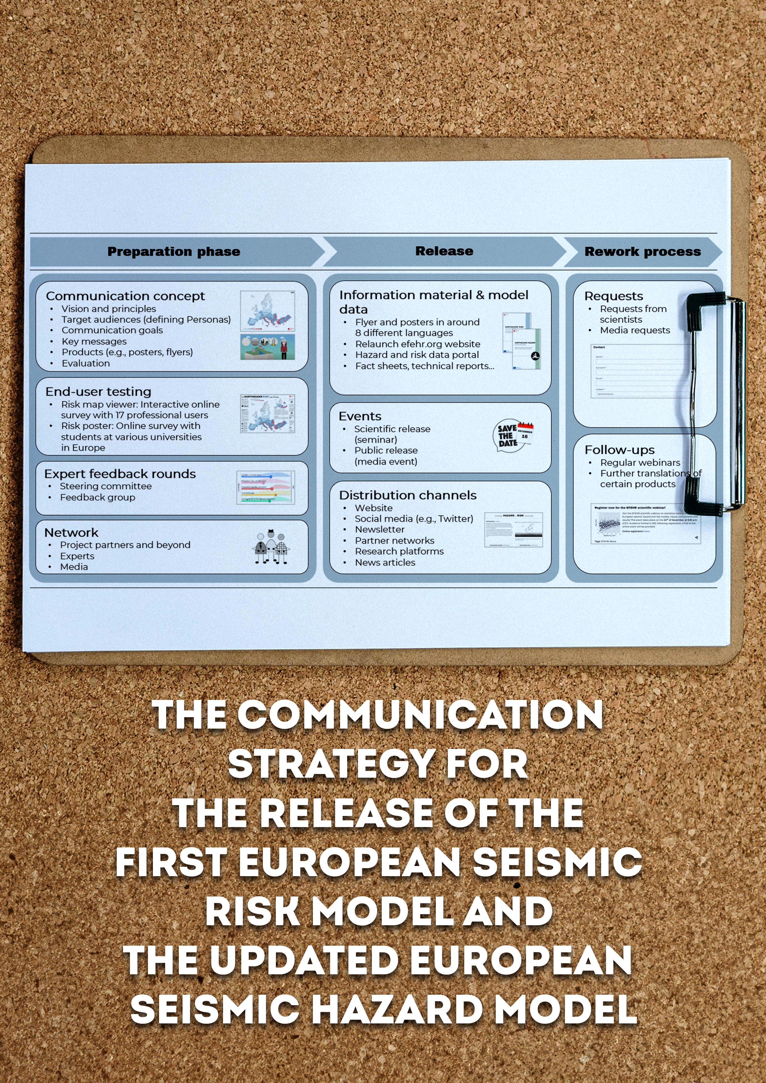
Publications The communication strategy for the release of the first European Seismic Risk Model and the updated European Seismic Hazard Model Share Facebook LinkedIn Download 2024 | Peer-reviewed To design user-centred and scientifically high-quality outreach products to inform about earthquake-related hazards and the associated risk, a close collaboration between the model developers and communication experts is needed. In this contribution, we present the communication strategy developed to support the public release of the first openly available European Seismic Risk Model and the updated European Seismic Hazard Model. The backbone of the strategy was the communication concept in which the overall vision, communication principles, target audiences (including personas), key messages, and products were defined. To fulfil the end-users' needs, we conducted two user testing surveys: one for the interactive risk map viewer and one for the risk poster with a special emphasis on the European earthquake risk map. To further ensure that the outreach products are not only understandable and attractive for different target groups but also adequate from a scientific point of view, a two-fold feedback mechanism involving experts in the field was implemented. Through a close collaboration with a network of communication specialists from other institutions supporting the release, additional feedback and exchange of knowledge was enabled. Our insights, gained as part of the release process, can support others in developing user-centred products reviewed by experts in the field to inform about hazard and risk models.
- ‘Rock recorders’ reveal drastic drop in earthquake hazard forecasts for Los Angeles - GEM Foundation
News ‘Rock recorders’ reveal drastic drop in earthquake hazard forecasts for Los Angeles By: Jan 18, 2024 Jan 18, 2024 Share Facebook LinkedIn Photo of one of the precariously balanced rocks studied as part of the project at Lovejoy Buttes. Blue and white tape on the PBR, and red and orange tape on the outcrop below. Yellow tape is used to accurately map the geometry of the base of the PBR. The pattern of joints(fractures) in the granite rock mean that this landscape has an abundance of fragile features. Imperial College London press release ----- Imperial College London scientists have challenged existing earthquake hazard estimates for the San Andreas fault near Los Angeles. The fault marks where two tectonic plates meet, and is responsible for some of California's largest earthquakes. The latest seismic hazard assessment, led by researchers at Imperial, suggests that the hazard of a giant earthquake on the Mojave section of the San Andreas fault area – the closest section to greater Los Angeles – is much lower. The team found that in the unlikely event that a once-in-10,000-years earthquake erupted on the San Andreas fault, the ground would shake 65 per cent less violently than previously thought. The ground shaking uncertainty range was 72 per cent lower than previous estimates – meaning that researchers are much more certain about the new estimate compared to previous estimates. To reach this conclusion, researchers investigated a group of precariously balanced rocks (PBRs) at Lovejoy Buttes, an area found 15 kilometres away from the San Andreas fault. PBRs are naturally balanced rock formations which are found worldwide and provide ancient geological data. Despite their delicate balance, PBRs have survived thousands of years of earthquakes without toppling, revealing insights into prehistorical seismic activity. In this way, they act as ‘inverse seismometers’ or earthquake ‘rock recorders’, as described by the researchers – since the PBRs have not toppled, they record ground shaking of large earthquakes that have not happened. Photo of a precariously balanced rock from elsewhere in southern California, same PBR as in DSCN2456. Senior author Dr Dylan Rood, from the Department of Earth Science and Engineering (ESE) at Imperial, said: “Earthquake hazard scientists are usually limited in their estimation of future earthquake hazard by the fact that modern seismometers have only been recording earthquake shaking for approximately the past hundred years. Therefore, when it comes to less frequent earthquakes happening over tens of thousands to millions of years, estimates become highly uncertain as more assumptions need to be made. “Our groundbreaking ‘inverse seismometers’ technique allows us to forecast large, infrequent earthquake ground shaking more precisely. These precariously balanced rocks overturn the hazard model for the San Andreas fault nearest to Los Angeles.” By precisely dating the age of the PBRs at Lovejoy Buttes and examining their structural fragility (and therefore the likelihood of toppling due to ground tremors), the team at Imperial obtained key information about what intensity of ground shaking can be expected during these rare, powerful San Andreas fault earthquakes. Photo of one of the precariously balanced rocks studied as part of the project at Lovejoy Buttes. The San Andreas fault runs along the base of the San Gabriel Mountains in the background of the photo, ~15 km away. This PBR has been fragile for ~28,500 years, so has survived the ground shaking from all those years of San Andreas fault earthquakes. The findings were presented at the AGU Annual Meeting last month and are published today in Seismological Research Letters . First author Dr Anna Rood, seismic hazard scientist at the Global Earthquake Model (GEM) Foundation and ESE and Civil and Environmental Engineering alumna, said: “We have innovated and implemented the most rigorous PBR validation methods to date. This is an important advance in earthquake hazard analysis, and practitioners should incorporate these methods. Our improved estimates have implications for the seismic hazard assessment of greater Los Angeles, which guide plans for disaster preparation, emergency responses and building codes. While a reduction in hazard may comfort residents of this earthquake-prone region, the magnitude of the inconsistency between our previous hazard estimates and the PBR survival raises important questions about our understanding of earthquake processes.” Researchers emphasised the need for independent data to validate seismic hazard estimates going forward. To improve the accuracy of estimates, they stress the importance of utilising the unique data over the timescales of rare, large earthquakes provided by fragile geologic features such as PBRs. Next, the team will use their inverse seismometer technique to validate seismic hazard estimates for other areas, including the Cascadia Subduction Zone in the Pacific Northwest, USA. Subduction zones generate the largest earthquakes on Earth, yet important questions remain about past and future shaking during magnitude nine megathrust earthquakes. The study was funded by the Southern California Earthquake Center (SCEC), the Lawrence Livermore National Laboratory, the US National Science Foundation and the Engineering and Physical Sciences Research Council (EPSRC) in the UK, part of UKRI. ‘San Andreas fault earthquake hazard model validation using probabilistic analysis of precariously balanced rocks and Bayesian updating’ by Anna H. Rood, Peter J. Stafford, Dylan H. Rood published 17 January 2024 in Seismological Research Letters. All photo credits: Dylan and Anna Rood ---------- For more information contact: Caroline Brogan, Media Manager (Engineering) Imperial College London caroline.brogan@imperial.ac.uk +44(0)20 7594 3415 +44(0)7745 650 147 Out of hours press officer mobile: +44 (0)7803 886248 About Imperial College London Imperial College London is a global top ten university with a world-class reputation. Imperial’s 22,000 students and 8,000 staff are working to solve the biggest challenges in science, medicine, engineering and business. Imperial ranks sixth in the 2024 QS World University Rankings and eighth in the 2024 Times Higher Education World University Rankings. The 2021 Research Excellence Framework (REF) found that it has a greater proportion of world-leading research than any other UK university. It also received a Gold Award in the 2023 Teaching Excellence Framework (TEF). Imperial was named University of the Year in the Daily Mail University Guide 2024, University of the Year for Graduate Employment in The Times and Sunday Times Good University Guide 2024, and awarded a Queen’s Anniversary Prize for its COVID-19 response. https://www.imperial.ac.uk/ No images found. GALLERY IMG_2362.JPG Photo of a precariously balanced rock from elsewhere in southern California, same PBR as in DSCN2456. DSCN1662.JPG Photo of one of the precariously balanced rocks studied as part of the project at Lovejoy Buttes. Blue and white tape on the PBR, and red and orange tape on the outcrop below. Yellow tape is used to accurately map the geometry of the base of the PBR. Close up of photo DSCN1575. This is oldest rock we studied at Lovejoy Buttes and is ~50,000 years old. This age is shown by the dark rock varnish that has developed on its surface over time. DSCN1575.JPG Photo of one of the precariously balanced rocks studied as part of the project at Lovejoy Buttes. Blue and white tape on the PBR, and red and orange tape on the outcrop below. Yellow tape is used to accurately map the geometry of the base of the PBR. The pattern of joints(fractures) in the granite rock mean that this landscape has an abundance of fragile features. IMG_2362.JPG Photo of a precariously balanced rock from elsewhere in southern California, same PBR as in DSCN2456. 1/8 All photo credits: Dylan and Anna Rood VIDEO RELATED CONTENTS