Thanks for submitting!
You will be contacted as soon as possible


Description
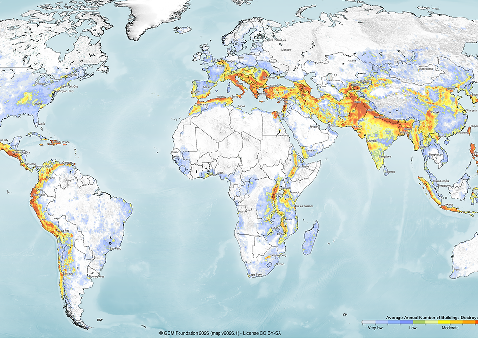
The v2026.1 Global Seismic Risk Model covers economic losses, number of buildings destroyed, built-up area destroyed, fatalities, population rendered homeless, and equivalent embodied carbon loss. The main seismic risk map presents the geographic distribution of the average annual number of buildings destroyed due to earthquake ground shaking across the residential, commercial, and industrial building stock. The assessment does not account for secondary earthquake- triggered hazards, such as tsunamis, liquefaction, landslides, or post-earthquake fires. Economic losses represent the direct physical impacts of earthquakes.
These results are an update of the global maps released in 2018, as described in Silva et al. (2020), and those released in 2023, and are based on best available and publicly accessible datasets and models, which have been collected, curated and maintained in collaboration between local experts and GEM Foundation scientists. The underlying dataset used to create the main map can be requested as a shapefile for use in research and public-good applications without cost, or for a licensing fee in the case of commercial applications.
How to cite this work
If you make use of this work, please cite both the publication and the poster. Publication: Silva, V.; Amo-Oduro, D.; Calderon, A, et al. (2020) Development of a global seismic risk model, Earthquake Spectra, vol. 36, no. 1_suppl, 2020, pp. 372–394. https://journals.sagepub.com/doi/abs/10.1177/8755293019899953 Poster: Silva V, Aljawhari K, Baiguera M, Calderon A, Caruso M, Costa C, Crowley H, González D, Nafeh AMB, Rao A, Yepes-Estrada C (2026). Global Earthquake Model (GEM) Seismic Risk Model Map (version 2026.1), https://doi.org/10.5281/zenodo.20208596
Available Versions
A PDF poster, as well as a set of high-resolution PNGs with each of the risk metrics calculated globally, is available for direct download under a CC BY-SA license. If your use case does not meet the open license requirements, or if you are interested in obtaining the underlying dataset as a shapefile, please submit a request in our system by clicking on the "License Request", where a specific license will be provided, depending on the use case. Additionally, users interested in the previous versions of the Global Seismic Risk Maps can access these from the table at the bottom of this page.
License information
The downloadable resources are available under a Creative Commons CC BY-SA 4.0 license, which requires:
Attribution (you must give appropriate credit, provide a link to the license, and indicate if changes were made)
ShareAlike (derivatives created must be made available under the same license as the original)
Any deviation from these terms incur in license infringement and requires a license agreement that must be made tailored to your use case, in such instance please click on "License Request".


Popup title
Country/Region | Available Resources |
|---|---|
Afghanistan | Vulnerability |
Africa | Vulnerability |
Alaska | Vulnerability |
Country/Region | Resource Url |
|---|---|
Afghanistan | Risk Profile |
Africa | Risk Profile |
Alaska | Risk Profile |
Search

Found
Country/Region | Resource Url |
|---|---|
Afghanistan | Vulnerability |
Africa | Vulnerability |
Alaska | Vulnerability |
Preview

Preview is not available.
Search
Found
Country/Region | Resource Url |
|---|---|
Afghanistan | Risk Profile |
Africa | Risk Profile |
Alaska | Risk Profile |
Preview
Preview is not available.
Previous Product Versions
Version Number | Data | Image | Poster | Documentation | Geoviewer |
v2018.1 | N/A | N/A | |||
v2023.1 |
Related products

Global Liquefaction Hazard

Global Exposure Model

Global Vulnerability Model

Global Seismic Embodied Carbon Risk

Global Seismic Risk Map

Country-Territory Seismic Risk Profiles

OpenQuake Engine

Global Seismic Hazard Map
Related publications

Development of a global seismic risk model