Thanks for submitting!
You will be contacted as soon as possible


CLOSE

QUICK LINKS


PROFILES
PUBLICATIONS
EXPOSURE
VULNERABILTY
SOFTWARE
EQ MODELS
Search Results
966 results found with an empty search
- CCARA | Global Earthquake Model Foundation
Projects CCARA Caribbean and Central America Earthquake Risk Assessment (CCARA) Versión en español English version Share Facebook LinkedIn Overview Outcomes Training Outreach Photos Publications Anchor 6 Background Earthquake risk is on the rise and earthquakes are expected to take an increasing number of lives. Hazard and risk assessments are the foundation for raising awareness among policy makers and the general public, forming the basis for decisions and actions that effectively build resilience and can reduce risk. While important work has been carried out in the Central American and Caribbean region to understand earthquake risk assessment and management there is still ample room to enhance that understanding and properly introduce it in decision- and policy-making processes. In many areas of the world, state-of-the-art information and tools to assess earthquake risk have been inaccessible for a long time. As a first step to tackle this problem, the Global Earthquake Model (GEM) has been created and spent the past 11 years collaboratively advancing open source science and technology for global state-of-the-art seismic hazard and risk modeling, data collection, and risk assessment at scales from local to national, regional, and global. Objectives The project aims to calculate hazard and risk, and to estimate the compounding social and economic factors that increase the physical damage and decrease the post-event capacities of populations to respond to and recover from damaging earthquake events in The Caribbean and Central America, by involving local experts from throughout the region. The goal of the Program in Central America and the Caribbean is to develop capacity in the region for earthquake risk assessment by leveraging GEM tools and resources, to enhance the understanding of earthquake risk, and to bridge the gap between risk assessment and disaster risk reduction. To improve the understanding of earthquake risk in the Central America and Caribbean region while developing local capacities to use open source resources for producing earthquake hazard and risk information at regional, national and local scales. To engage with decision-makers and other end-users to make the connection between advanced risk assessment by local experts and risk-reducing action and so influence DRR policy. Collaborators The CCARA project would not have been possible without the contributions of all the municipalities in particular: the Municipality of San José (Costa Rica), National Commission of Emergencies (CNE), University of Costa Rica (UCR) - Laboratorio Nacional de Materiales y Estructuras (LANAMME), INETER, ONESVIE, ODPEM, BRGM, Bureau des Mines, VT, Geologica UPR Mayaquez, UNI, SRC and UMG. Location Caribbean and Central America countries Website Caribbean and Central America Earthquake Risk Assessment (CCARA) wiki site contains an overview of the project. Anchor 1 Anchor 5 The CCARA project hosted four participants from South America to introduce seismic hazard and risk assessment using tools developed by GEM – specifically the OpenQuake engine. Anchor 4 Modelling subduction earthquakes: GEM experiences in Latin America CCARA project GEM presents the results of the USAID-funded CCARA Project in Santo Domingo, Dominican Republic A hazard workshop in San José, Costa Rica from September 18th to 22nd as part of the risk assessment activities of the CCARA project. Anchor3 Publications CCAF-DB: The Caribbean and Central American Active Fault Database Disclaimer The contents of this project website such as studies, reports, audio-visual, news articles, blogs, and other information or media products including those in the external links are made possible by the generous support of the American people through the United States Agency for International Development (USAID). The contents are the responsibility of the Global Earthquake Model (GEM) Foundation and do not necessarily reflect the views of USAID or the United States Government.
- ALBANIA HAZARD MODELLING | Global Earthquake Model Foundation
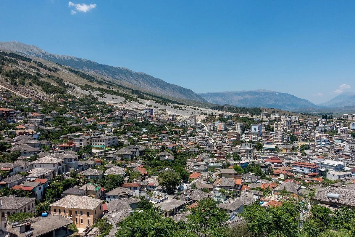
Projects ALBANIA HAZARD MODELLING Joint development of the Albanian seismic hazard model Versión en español English version Share Facebook LinkedIn Overview Outcomes Training Outreach Photos Publications Anchor 6 Background GEM and IGEO-Albania are currently implementing a 1-year project funded by the European Investment Fund and supported by the Electrical Corporation of Albania to update Albania’s probabilistic seismic hazard model through a series of technical workshops. The GEM Hazard Team is providing support on the use of its open source tools for hazard model building and assessment. Duration: 2023 Objectives The main objectives of this project are to update the national seismic hazard model for Albania, and provide the outputs that can be used in the National Annex of Eurocode 8, for the seismic design of buildings in Albania. Collaborators GEM Foundation, Institute of Geosciences (IGEO) Funding Partner: European Investment Fund, Electrical Corporation of Albania Location Albania Anchor 1 Anchor 5 Anchor 4 Strengthening Albania's Earthquake Preparedness: A Collaborative Effort This project, funded by the Central European Initiative and supported by the Albanian Electricity Corporation, has two objectives. It aims to modernize Albania's seismic hazard map, a crucial step in updating the nation's building code to meet Eurocode 8 standards. This marks the first significant revision to Albania's building regulations since 1989. A more updated view of seismic hazard will help in promoting more cost-effective earthquake-resistant construction practices. Read more Albania’s Institute of Geosciences (IGEO) and GEM collaborate to update the national seismic hazard model GEM and IGEO-Albania implemented a 1-year project funded by the Central European Initiative (CEI - https://www.cei.int/) and the Albanian Electricity Corporation (KESH - https://www.kesh.al/en/) to update Albania's probabilistic seismic hazard model through a series of technical workshops. Read more Anchor3 BUSINESS NEWS NSHMA 2024 Presentation, Tirana, Albania - July 16, 2024 Photo credits: IGEO 1/3 BUSINESS NEWS GEM - IGEO Albania Workshop, Pavia 2023 1/4 Publications
- SERA Project | Global Earthquake Model Foundation
Projects SERA Project Seismology and Earthquake Engineering Research Infrastructure Alliance for Europe (SERA) Versión en español English version Share Facebook LinkedIn Overview Anchor 6 Background The Seismology and Earthquake Engineering Research Infrastructure Alliance for Europe (SERA) aims to reduce the risk posed by natural and anthropogenic earthquakes based on innovative research and development projects. SERA will significantly improve the access to data, services and research infrastructures for scientists and other professionals. GEM's contributions focus on taxonomy and exposure of residential, commercial and industrial buildings in Europe; physical vulnerability assessment for buildings; integrated earthquake risk analysis using the risk assessment framework and OpenQuake software established by the Global Earthquake Model. SERA is a Horizon 2020-supported programme responding to the priorities identified in the topic INFRAIA-01-2016-2017 ‘Integrating Activities for Advanced Communities’. SERA involves 31 partners and 8 linked third parties in Europe. It started in May 2017 and will last for three years. Objectives The EUCENTRE-SERA project is collaborating closely with the GEM Foundation (Global Earthquake Model) to: develop a European Risk Modelling framework that brings together the strengths of previous projects such as SHARE, NERA and fills in the research gaps; integrate knowledge and data from other SERA working packages; and build on the risk assessment framework and software developed by GEM. SERA is engaging 31 partners from 16 European countries. They all have leading expertise in the operation of experimental facilities, monitoring infrastructures, and data repositories in the fields of seismology, anthropogenic hazards or earthquake engineering. (complete list ) Location Europe Anchor 1 Anchor 5 Anchor 4 EM-SERA OpenQuake Training in Istanbul, Turkey SERA European Building Exposure Workshop: From European Hazard to Risk Anchor3 Publications
- HORUS | Global Earthquake Model Foundation
Projects HORUS Horus: Pilot for a generic damage evaluation methodology based on remote-sensing data Versión en español English version Share Facebook LinkedIn Overview Anchor 6 Background Horus is a pilot project that explores the combination of high-resolution building inventory data from OpenStreetMap and other local sources with image-processing algorithms for the detection of earthquake damage and flood extents using remote-sensing data, along with supplementary geospatial datasets as inputs to a machine learning (ML) classification model. The ML model is trained using detailed building damage datasets from past events in a supervised learning framework, and the trained model is intended to be used to estimate the extent of damage and loss in events previously unseen by the model. The proposed framework is applied in three case study applications: March 2020 Mw5.3 Zagreb earthquake; January 2020 Mw6.4 Puerto Rico earthquake and August 2016 Louisiana floods. The GEM Risk Team is responsible for the overall coordination of the project involving multiple partners, compilation of building-level earthquake damage datasets, development of the ML models, and training and testing of the models. Duration: 2020 Objectives This pilot project, initiated and funded by the World Bank, aims to develop a framework for semi-automated damage and loss assessment due to earthquake and floods from Earth Observation (EO) data and other supplementary datasets, while also leveraging recent advances in machine-learning algorithms. These damage and loss estimates can potentially be used for transparent financial compensation and to target the distribution of resources geographically and temporally. Collaborators Advanced Rapid Imaging and Analysis (ARIA) team at the National Aeronautics and Space Administration’s (NASA) Jet Propulsion Laboratory (JPL) and California Institute of Technology (Caltech), the Global Earthquake Model (GEM) Foundation, JBA Risk, and the Humanitarian OpenStreetMap Team (HOT) Funding partner: World Bank Group Locations Earthquake case studies: Gorkha, Nepal; Puebla, Mexico; Puerto Rico, United States; Zagreb, Croatia Flood case study: Louisiana, United States Anchor 1 Anchor 5 Anchor 4 Anchor3 Publications
- Collaborative Projects | Global Earthquake Model Foundation | Italy
Hazard and risk assessment projects with regional, national and local collaborators covering more than 150 countries in Europe, Middle East, South America, Central America, North America, Sub-Saharan Africa, Asia and the Pacific. PROJECTS GEM’s collaborative network comprises more than 100 public and private institutions, which has led to GEM’s participation in more than 50 regional, national, and multilateral projects covering Europe, Middle East, South America, Central America, North America, Sub-Saharan Africa, Asia and the Pacific. Share Facebook X (Twitter) LinkedIn Anchor 1 Key Projects - 2013 and beyond Sort by Order by 1 2 3 4 5 1 ... 1 2 3 4 5 6 7 8 9 ... 9 0 Filters: 43 results found View: Map List Gallery Piattaforma Analisi Pericolosità E Rischio Sismico Status: Ongoing The Global Earthquake Model (GEM) Foundation has launched the PAPERS project (Piattaforma Analisi Pericolosità E Rischio Sismico), an initiative aimed at developing a new WebGIS platform for scenario hazard and risk assessment in Italy. The project has been funded as one of the cascade grants launched by the High-Performance Computing, Big Data e Quantum Computing Research Centre, one of the five National Centres established by the Italian National Recovery and Resilience Plan (NRRP), under Spoke 5 - Environment and Natural Disasters . View COMET-GEM Central Asia Seismic Hazard Project Status: Ongoing The COMET-GEM collaboration aims to develop an advanced, publicly accessible seismic hazard and risk model for Central Asia, integrating cutting-edge scientific methods such as satellite geodesy, palaeoseismology, and geodetic data analysis. View WFP-ADAM+ Innovation Accelerator Project Status: Ongoing The project aims to integrate GEM’s earthquake risk methodologies and datasets into humanitarian emergency preparedness and response efforts. By leveraging GEM’s expertise, the project seeks to enhance global access to reliable earthquake risk data and post-disaster impact assessments for humanitarian actors. View Renovation with automation and optimization of processes and products Status: Ongoing This EU-funded initiative, supported by CINEA - European Climate, Infrastructure and Environment Executive Agency as the granting authority, is set to transform the renovation process by introducing advanced solutions that streamline every stage - from design to end-of-life - achieving significant cost and time savings. View North-Eastern Atlantic and Mediterranean Tsunami Risk Management and Planning Status: Ongoing The project aims to improve tsunami risk management and planning in the NEAM region North-Eastern Atlantic and Mediterranean). It endeavors to contribute to two key components of tsunami risk governance: capacity building through tsunami hazard assessment and mapping at the national scale, and improved tsunami evacuation planning at the local level through a novel multi-hazard approach. View Title Location Status Piattaforma Analisi Pericolosità E Rischio Sismico Pilot Site for Seismic Risk Analysis: An Italian city to be determined during the project, intended as a demonstration case for urban-scale seismic risk analysis. Testing Locations: The project will involve data collection and analysis on a national scale across Italy. Ongoing COMET-GEM Central Asia Seismic Hazard Project Primary Focus Region: Central Asia Additional Areas of Study: South Caucasus, Türkiye, Mongolia Ongoing WFP-ADAM+ Innovation Accelerator Project Earthquake-prone WFP Countries with initial pilots in Afghanistan, Nepal, Turkey, Syria, Haiti, and the Philippines. Ongoing Renovation with automation and optimization of processes and products Austria Ongoing North-Eastern Atlantic and Mediterranean Tsunami Risk Management and Planning Southern Europe Ongoing European Plate Observing System-Optimisation and EvolutioN (EPOS ON) Project Europe Ongoing ASCE Earthquake Loads Overseas (AELO) Global (Washington DC, USA) Ongoing Strengthening capacity on disaster risk assessment, reduction and transfer instruments in Mongolia Mongolia Completed Assessing the Risk Exposure of Road Network to Climate and Natural Hazard Risks in Solomon Islands Solomon Islands Completed Seismic Resilience Baseline Analysis and Investment Option Needs in Indonesia Indonesia: ‣ Kota Bengkulu, Bengkulu province ‣ Kota Cilegon, Banten province ‣ Kota Gorontalo, Gorontalo province Completed Page 1 of 5 1 2 3 4 5 1 ... 1 2 3 4 5 6 7 8 9 ... 9 Completed Ongoing Washington DC Close Completed Location Ongoing
- Project locations world map | GEM Foundation
Close Completed Location Ongoing
- Products and Services Strategy document | Global Earthquake Model Foundation
Products and Services Strategy document of GEM Foundation GEM PRODUCTS and SERVICES STRATEGY DOCUMENT The GEM Products and Services Strategy aims to sustainably provide accessible information. GEM will expand its offerings, leveraging its tools and data to meet the diverse needs of providers, users, and the broader DRR community. OVERVIEW FAQs 0. Overview The key objective of GEM’s Products and Services Strategy is to continue to make all information freely available, with an emphasis on open access, while at the same time assuring the sustainability of the organisation. Although GEM has been continuously and generously supported by public and private institutions for more than 15 years, the development of products and services to meet the existing and future needs of the disaster risk reduction community requires additional support and funding, which GEM has sought through engaging in more institutional projects and through more investment in commercial products and services. GEM’s products and services are released through different mechanisms depending on the product, and these can be simply categorised in three ways: open software, data and models (under different open license conditions described here); freely available software, data and models available for non-commercial, public good use, following a license request; commercial-use products and services (i.e. subject to a license fee). It is worth underlining that all of GEM’s products are always available freely for non-commercial, public good use, regardless of the mechanism under which they are primarily released. As a non-profit organisation, any revenue derived from commercial sales of products or services are reinvested to fund GEM’s core programmes (i.e. advancing capabilities in earthquake and multi-hazard risk, pioneering scientific risk assessment methods, and expanding risk and resilience applications to downstream users), with an emphasis on providing support to countries in the Global South Frequently Asked Questions (FAQ) This section provides detailed information on how to access GEM’s Open products (Part A) and License request products (Part B), including how to access these products for free. This section also contains specific explanations of the most common questions about GEM’s products and services. overview faq A. Open Products A.1 Where can I find and download the full list of GEM’s open products? From the Products webpage (https://www.globalquakemodel.org/products ), you can select to see a list of products with open licenses, as shown in the video below. A.2 What are GEM’s top or flagship open products? GEM’s flagship products are OpenQuake software and the Global Earthquake Hazard and Risk Models and Maps. A.3 Why does GEM develop open products? GEM develops open products to make high-quality scientific products in earthquake hazard and risk analysis readily available for public good. Most high-calibre software or data are closed/proprietary or very expensive. To break this barrier, GEM releases open products in order to promote access to and sharing of information, to promote collaboration and transparency, and thereby build trust among partners and the public. A.4 What is an open product, and how does GEM define open? An open product is a digital or technology-based product that is free of cost and accessible, though access may be governed by specific conditions of use. An open product can be a software (open source code), a scientific publication (open access) or a database (open data). The GEM Foundation distributes open-source software and open data. With limited exceptions, intellectual products by the GEM Foundation are released with open licenses, such as the GNU AGPL for software and the Creative Commons licenses for creative contents, datasets and models. You can check the full details here . A.5 What license types govern GEM’s open products? Can I use GEM’s open products for commercial purposes? Many of GEM’s products are released under a CC BY-SA license. These products may be used commercially provided any distribution of derived products is attributed to the GEM Foundation (BY = by attribution) and they are redistributed with the same (SA = share-alike) license. If the license is CC BY-NC-SA, in addition, the product or its derivatives may not be used commercially (NC = non-commercial). You may request to use a GEM product under different license conditions (e.g. for commercial use) by filling in a License Request form (see Part B below). GEM’s OpenQuake software and related tools are released under an AGPL license, which also has no commercial restrictions, and derived products may only be distributed under the same open license. You can check the full details of our licensing terms here . In addition, please refer to GEM’s terms of use and licensing policy . B. License Request Products B.1 Why is GEM not providing all of its products openly? Some of the more commercially attractive products (e.g. higher resolution datasets) are not made openly available, but are instead only shared through the signing of a license agreement. In this case, we grant access under a more restricted license that forbids distribution or disclosure and requires signing by GEM and the licensee in order to better assure accountability for the confidentiality of the information. For commercial use of those products, GEM requests a commercial license fee to generate additional income to further support the development of free and open products. Nevertheless, all products that are made available for a fee are also available for free for non-commercial, public-good applications (i.e. academic, government or humanitarian projects, etc.). B.2 What products are being offered for a fee? From the Products webpage (https://www.globalquakemodel.org/products ) you can select to see a list of products with NC (non-commercial) or custom licenses, as shown in the screenshot below. For commercial use of those products, GEM requests a commercial license fee to generate additional income to further support its mission. B.3 How does GEM use the income from products made available for a fee? Revenue generated from commercial licenses is reinvested in public good activities with particular emphasis on the Global South. B.4 I’m a government officer and working on a DRR project and the product I need is not openly available. How can I obtain that product? All products on the GEM website have a License Request button. In this request we ask you to provide details on the requesting party, the License agreement signatory and a description of the purpose of the request. An example is shown below. GEM Secretariat will contact you for further evaluation of your request, and the next steps. B.5 I am an academic conducting research on earthquake hazard and risk in my country and the product I need is not openly available. How can I obtain that product? See the response to B.4. B.6 We’re a humanitarian organization in the field of DRR and the product we need is not openly available. Can we obtain that product? See the response to B.4.
- Post Event Info Edit | GEM Foundation
UPDATE POST EVENT INFO To update a post-event entry, select a row from the table below. The details of the selected row will appear beneath the table. All elements or fields on this page are editable (you can add or delete items) except for the Alert ID field, which is locked as it serves as the primary key (a unique identifier in the post-event datasets). After making your updates, click the Update button. There is no limit to the number of times a specific post-event entry or row can be updated. Date Alert ID City Country 31/03/2025 ID-TEST demo demo 28/03/2025 us7000pn9s Mandalay Myanmar 07/01/2025 us6000pi9w Tingri County Tibet Autonomous Region 22/01/2024 us7000lsze Aykol China 01/01/2024 us6000m0xl Ishikawa Japan Date Activated Alert ID City Related GEM products Products list ADD California (UCERF3) | Caribbean & Central America Exposure | OpenQuake QGIS Plugin | Taiwan Hazard | Africa Exposure Country Short Event description demo Event description demo PAGER Alert URL Related GEM publications Publications list ADD Earthquake-induced liquefaction and landslides in Cali, Colombia | User guide Android mobile tool for field data collection | Variable resolution probabilistic modeling of residential exposure and vulnerability for risk applications Upload PAGER Alert image Select File Other Resources Product Name Product Url ADD List of products List of external products Normal Text Publication Name Publication Url ADD List of publications List of external publications Normal Text Homepage Expiration Date Page behaviour and visibility settings Display on Homepage Display Alert ID on landing page Disable expiration date (if disabled the expiration date will be in 7 days) EDIT An error occurred. Try again later Your content has been edited
- GEM Products | GEM Foundation
To improve earthquake resilience, GEM offers collaborative services, products and resources that can be used for public and commercial purposes by organisations or individuals worldwide. GEM's products and services are transparent, accessible, credible and applicable not only for disaster prevention. PRODUCTS All of GEM’s products are freely available for public good, non-commercial use, but they may have different license restrictions. Open and free distribution of data, models, and tools remains at the core of GEM’s work, further enhancing their availability and accessibility. Share Facebook X (Twitter) LinkedIn Flagship Products NEW Global Hazard Map NEW Global Exposure Model NEW OpenQuake Engine NEW Global Vulnerability Model NEW Global Risk Map NEW Risk Profiles Anchor 1 Search Map List Gallery Map List Gallery Available Seismic Hazard and Risk Models and Datasets The gallery or list will show the region, country, or territory that currently has GEM seismic hazard and exposure models based on your search input. Filter by product type: Model Software Map Dataset Filter by model component: All (cross-cutting) Exposure Hazard Risk Vulnerability Financial Loss Filter by license type: AGPL v3.0 CC BY 4.0 CC BY-SA 4.0 CC BY-NC-SA 4.0 Custom license Reset By selecting a region in the global map below, a table will appear to quickly take you to the available resources in that region. You can also use the Search box to look up any specific region, country or territory. Popup title Close Country/Region Afghanistan Hazard Exposure Vulnerability Risk Profile Africa Hazard Exposure Vulnerability Risk Profile Alaska Hazard Exposure Vulnerability Risk Profile Albania Hazard Exposure Vulnerability Risk Profile Algeria Hazard Exposure Vulnerability Risk Profile American Samoa Hazard Exposure Vulnerability Risk Profile Andorra Hazard Exposure Vulnerability Risk Profile Angola Hazard Exposure Vulnerability Risk Profile Anguilla Hazard Exposure Vulnerability Risk Profile Antigua and Barbuda Hazard Exposure Vulnerability Risk Profile Arabia Hazard Exposure Vulnerability Risk Profile Argentina Hazard Exposure Vulnerability Risk Profile Armenia Hazard Exposure Vulnerability Risk Profile Aruba Hazard Exposure Vulnerability Risk Profile Australia Hazard Exposure Vulnerability Risk Profile Austria Hazard Exposure Vulnerability Risk Profile Azerbaijan Hazard Exposure Vulnerability Risk Profile Bahamas Hazard Exposure Vulnerability Risk Profile Bahrain Hazard Exposure Vulnerability Risk Profile Bangladesh Hazard Exposure Vulnerability Risk Profile Barbados Hazard Exposure Vulnerability Risk Profile Belarus Hazard Exposure Vulnerability Risk Profile Belgium Hazard Exposure Vulnerability Risk Profile Belize Hazard Exposure Vulnerability Risk Profile Benin Hazard Exposure Vulnerability Risk Profile Bhutan Hazard Exposure Vulnerability Risk Profile Bolivia Hazard Exposure Vulnerability Risk Profile Bosnia and Herzegovina Hazard Exposure Vulnerability Risk Profile Botswana Hazard Exposure Vulnerability Risk Profile Brazil Hazard Exposure Vulnerability Risk Profile British Virgin Islands Hazard Exposure Vulnerability Risk Profile Brunei Hazard Exposure Vulnerability Risk Profile Bulgaria Hazard Exposure Vulnerability Risk Profile Burkina Faso Hazard Exposure Vulnerability Risk Profile Burundi Hazard Exposure Vulnerability Risk Profile Cambodia Hazard Exposure Vulnerability Risk Profile Cameroon Hazard Exposure Vulnerability Risk Profile Canada Hazard Exposure Vulnerability Risk Profile Cape Verde Hazard Exposure Vulnerability Risk Profile Caribbean Central America Hazard Exposure Vulnerability Risk Profile Cayman Islands Hazard Exposure Vulnerability Risk Profile Central African Republic Hazard Exposure Vulnerability Risk Profile Central Asia Hazard Exposure Vulnerability Risk Profile Chad Hazard Exposure Vulnerability Risk Profile Chile Hazard Exposure Vulnerability Risk Profile China Hazard Exposure Vulnerability Risk Profile Colombia Hazard Exposure Vulnerability Risk Profile Comoros Hazard Exposure Vulnerability Risk Profile Congo Hazard Exposure Vulnerability Risk Profile Conterminous US Hazard Exposure Vulnerability Risk Profile Cook Islands Hazard Exposure Vulnerability Risk Profile Costa Rica Hazard Exposure Vulnerability Risk Profile Croatia Hazard Exposure Vulnerability Risk Profile Cuba Hazard Exposure Vulnerability Risk Profile Cyprus Hazard Exposure Vulnerability Risk Profile Czechia Hazard Exposure Vulnerability Risk Profile Democratic Republic of the Congo Hazard Exposure Vulnerability Risk Profile Denmark Hazard Exposure Vulnerability Risk Profile Djibouti Hazard Exposure Vulnerability Risk Profile Dominica Hazard Exposure Vulnerability Risk Profile Dominican Republic Hazard Exposure Vulnerability Risk Profile East Asia Hazard Exposure Vulnerability Risk Profile Ecuador Hazard Exposure Vulnerability Risk Profile Egypt Hazard Exposure Vulnerability Risk Profile El Salvador Hazard Exposure Vulnerability Risk Profile Equatorial Guinea Hazard Exposure Vulnerability Risk Profile Eritrea Hazard Exposure Vulnerability Risk Profile Estonia Hazard Exposure Vulnerability Risk Profile Eswatini Hazard Exposure Vulnerability Risk Profile Ethiopia Hazard Exposure Vulnerability Risk Profile Europe Hazard Exposure Vulnerability Risk Profile Fiji Hazard Exposure Vulnerability Risk Profile Finland Hazard Exposure Vulnerability Risk Profile France Hazard Exposure Vulnerability Risk Profile French Guiana Hazard Exposure Vulnerability Risk Profile Gabon Hazard Exposure Vulnerability Risk Profile Gambia Hazard Exposure Vulnerability Risk Profile Georgia Hazard Exposure Vulnerability Risk Profile Germany Hazard Exposure Vulnerability Risk Profile Ghana Hazard Exposure Vulnerability Risk Profile Gibraltar Hazard Exposure Vulnerability Risk Profile Greece Hazard Exposure Vulnerability Risk Profile Grenada Hazard Exposure Vulnerability Risk Profile Guadeloupe Hazard Exposure Vulnerability Risk Profile Guam Hazard Exposure Vulnerability Risk Profile Guatemala Hazard Exposure Vulnerability Risk Profile Guinea Hazard Exposure Vulnerability Risk Profile Guinea Bissau Hazard Exposure Vulnerability Risk Profile Guyana Hazard Exposure Vulnerability Risk Profile Haiti Hazard Exposure Vulnerability Risk Profile Hawaii Hazard Exposure Vulnerability Risk Profile Honduras Hazard Exposure Vulnerability Risk Profile Hong Kong Hazard Exposure Vulnerability Risk Profile Hungary Hazard Exposure Vulnerability Risk Profile Iceland Hazard Exposure Vulnerability Risk Profile India Hazard Exposure Vulnerability Risk Profile Indonesia Hazard Exposure Vulnerability Risk Profile Iran Hazard Exposure Vulnerability Risk Profile Iraq Hazard Exposure Vulnerability Risk Profile Ireland Hazard Exposure Vulnerability Risk Profile Isle of Man Hazard Exposure Vulnerability Risk Profile Israel Hazard Exposure Vulnerability Risk Profile Italy Hazard Exposure Vulnerability Risk Profile Ivory Coast Hazard Exposure Vulnerability Risk Profile Jamaica Hazard Exposure Vulnerability Risk Profile Japan Hazard Exposure Vulnerability Risk Profile Jordan Hazard Exposure Vulnerability Risk Profile Kazakhstan Hazard Exposure Vulnerability Risk Profile Kenya Hazard Exposure Vulnerability Risk Profile Kiribati Hazard Exposure Vulnerability Risk Profile Kosovo Hazard Exposure Vulnerability Risk Profile Kuwait Hazard Exposure Vulnerability Risk Profile Kyrgyzstan Hazard Exposure Vulnerability Risk Profile Laos Hazard Exposure Vulnerability Risk Profile Latvia Hazard Exposure Vulnerability Risk Profile Lebanon Hazard Exposure Vulnerability Risk Profile Lesotho Hazard Exposure Vulnerability Risk Profile Liberia Hazard Exposure Vulnerability Risk Profile Libya Hazard Exposure Vulnerability Risk Profile Liechtenstein Hazard Exposure Vulnerability Risk Profile Lithuania Hazard Exposure Vulnerability Risk Profile Luxembourg Hazard Exposure Vulnerability Risk Profile Macao Hazard Exposure Vulnerability Risk Profile Madagascar Hazard Exposure Vulnerability Risk Profile Malawi Hazard Exposure Vulnerability Risk Profile Malaysia Hazard Exposure Vulnerability Risk Profile Mali Hazard Exposure Vulnerability Risk Profile Malta Hazard Exposure Vulnerability Risk Profile Marshall Islands Hazard Exposure Vulnerability Risk Profile Martinique Hazard Exposure Vulnerability Risk Profile Mauritania Hazard Exposure Vulnerability Risk Profile Mauritius Hazard Exposure Vulnerability Risk Profile Mexico Hazard Exposure Vulnerability Risk Profile Micronesia Hazard Exposure Vulnerability Risk Profile Middle East Hazard Exposure Vulnerability Risk Profile Moldova Hazard Exposure Vulnerability Risk Profile Monaco Hazard Exposure Vulnerability Risk Profile Mongolia Hazard Exposure Vulnerability Risk Profile Montenegro Hazard Exposure Vulnerability Risk Profile Montserrat Hazard Exposure Vulnerability Risk Profile Morocco Hazard Exposure Vulnerability Risk Profile Mozambique Hazard Exposure Vulnerability Risk Profile Myanmar Hazard Exposure Vulnerability Risk Profile Namibia Hazard Exposure Vulnerability Risk Profile Nauru Hazard Exposure Vulnerability Risk Profile Nepal Hazard Exposure Vulnerability Risk Profile Netherlands Hazard Exposure Vulnerability Risk Profile New Caledonia Hazard Exposure Vulnerability Risk Profile New Zealand Hazard Exposure Vulnerability Risk Profile Nicaragua Hazard Exposure Vulnerability Risk Profile Niger Hazard Exposure Vulnerability Risk Profile Nigeria Hazard Exposure Vulnerability Risk Profile Niue Hazard Exposure Vulnerability Risk Profile North Africa Hazard Exposure Vulnerability Risk Profile North America Hazard Exposure Vulnerability Risk Profile North Asia Hazard Exposure Vulnerability Risk Profile North Korea Hazard Exposure Vulnerability Risk Profile North Macedonia Hazard Exposure Vulnerability Risk Profile North and South Korea Hazard Exposure Vulnerability Risk Profile Northeast Asia Hazard Exposure Vulnerability Risk Profile Northern Mariana Islands Hazard Exposure Vulnerability Risk Profile Northwest Asia Hazard Exposure Vulnerability Risk Profile Norway Hazard Exposure Vulnerability Risk Profile Oceania Hazard Exposure Vulnerability Risk Profile Oman Hazard Exposure Vulnerability Risk Profile Pacific Islands Hazard Exposure Vulnerability Risk Profile Pakistan Hazard Exposure Vulnerability Risk Profile Palau Hazard Exposure Vulnerability Risk Profile Palestine Hazard Exposure Vulnerability Risk Profile Panama Hazard Exposure Vulnerability Risk Profile Papua New Guinea Hazard Exposure Vulnerability Risk Profile Paraguay Hazard Exposure Vulnerability Risk Profile Peru Hazard Exposure Vulnerability Risk Profile Philippines Hazard Exposure Vulnerability Risk Profile Poland Hazard Exposure Vulnerability Risk Profile Portugal Hazard Exposure Vulnerability Risk Profile Puerto Rico Hazard Exposure Vulnerability Risk Profile Qatar Hazard Exposure Vulnerability Risk Profile Romania Hazard Exposure Vulnerability Risk Profile Russia Hazard Exposure Vulnerability Risk Profile Rwanda Hazard Exposure Vulnerability Risk Profile Saint Kitts and Nevis Hazard Exposure Vulnerability Risk Profile Saint Lucia Hazard Exposure Vulnerability Risk Profile Saint Vincent and the Grenadines Hazard Exposure Vulnerability Risk Profile Samoa Hazard Exposure Vulnerability Risk Profile Sao Tome and Principe Hazard Exposure Vulnerability Risk Profile Saudi Arabia Hazard Exposure Vulnerability Risk Profile Senegal Hazard Exposure Vulnerability Risk Profile Serbia Hazard Exposure Vulnerability Risk Profile Seychelles Hazard Exposure Vulnerability Risk Profile Sierra Leone Hazard Exposure Vulnerability Risk Profile Singapore Hazard Exposure Vulnerability Risk Profile Slovakia Hazard Exposure Vulnerability Risk Profile Slovenia Hazard Exposure Vulnerability Risk Profile Solomon Islands Hazard Exposure Vulnerability Risk Profile Somalia Hazard Exposure Vulnerability Risk Profile South Africa Hazard Exposure Vulnerability Risk Profile South America Hazard Exposure Vulnerability Risk Profile South Asia Hazard Exposure Vulnerability Risk Profile South Korea Hazard Exposure Vulnerability Risk Profile Country/Region Afghanistan Hazard Exposure Vulnerability Risk Profile Africa Hazard Exposure Vulnerability Risk Profile Alaska Hazard Exposure Vulnerability Risk Profile Albania Hazard Exposure Vulnerability Risk Profile Algeria Hazard Exposure Vulnerability Risk Profile American Samoa Hazard Exposure Vulnerability Risk Profile Andorra Hazard Exposure Vulnerability Risk Profile Angola Hazard Exposure Vulnerability Risk Profile Anguilla Hazard Exposure Vulnerability Risk Profile Antigua and Barbuda Hazard Exposure Vulnerability Risk Profile Arabia Hazard Exposure Vulnerability Risk Profile Argentina Hazard Exposure Vulnerability Risk Profile Armenia Hazard Exposure Vulnerability Risk Profile Aruba Hazard Exposure Vulnerability Risk Profile Australia Hazard Exposure Vulnerability Risk Profile Austria Hazard Exposure Vulnerability Risk Profile Azerbaijan Hazard Exposure Vulnerability Risk Profile Bahamas Hazard Exposure Vulnerability Risk Profile Bahrain Hazard Exposure Vulnerability Risk Profile Bangladesh Hazard Exposure Vulnerability Risk Profile Barbados Hazard Exposure Vulnerability Risk Profile Belarus Hazard Exposure Vulnerability Risk Profile Belgium Hazard Exposure Vulnerability Risk Profile Belize Hazard Exposure Vulnerability Risk Profile Benin Hazard Exposure Vulnerability Risk Profile Bhutan Hazard Exposure Vulnerability Risk Profile Bolivia Hazard Exposure Vulnerability Risk Profile Bosnia and Herzegovina Hazard Exposure Vulnerability Risk Profile Botswana Hazard Exposure Vulnerability Risk Profile Brazil Hazard Exposure Vulnerability Risk Profile British Virgin Islands Hazard Exposure Vulnerability Risk Profile Brunei Hazard Exposure Vulnerability Risk Profile Bulgaria Hazard Exposure Vulnerability Risk Profile Burkina Faso Hazard Exposure Vulnerability Risk Profile Burundi Hazard Exposure Vulnerability Risk Profile Cambodia Hazard Exposure Vulnerability Risk Profile Cameroon Hazard Exposure Vulnerability Risk Profile Canada Hazard Exposure Vulnerability Risk Profile Cape Verde Hazard Exposure Vulnerability Risk Profile Caribbean Central America Hazard Exposure Vulnerability Risk Profile Cayman Islands Hazard Exposure Vulnerability Risk Profile Central African Republic Hazard Exposure Vulnerability Risk Profile Central Asia Hazard Exposure Vulnerability Risk Profile Chad Hazard Exposure Vulnerability Risk Profile Chile Hazard Exposure Vulnerability Risk Profile China Hazard Exposure Vulnerability Risk Profile Colombia Hazard Exposure Vulnerability Risk Profile Comoros Hazard Exposure Vulnerability Risk Profile Congo Hazard Exposure Vulnerability Risk Profile Conterminous US Hazard Exposure Vulnerability Risk Profile Cook Islands Hazard Exposure Vulnerability Risk Profile Costa Rica Hazard Exposure Vulnerability Risk Profile Croatia Hazard Exposure Vulnerability Risk Profile Cuba Hazard Exposure Vulnerability Risk Profile Cyprus Hazard Exposure Vulnerability Risk Profile Czechia Hazard Exposure Vulnerability Risk Profile Democratic Republic of the Congo Hazard Exposure Vulnerability Risk Profile Denmark Hazard Exposure Vulnerability Risk Profile Djibouti Hazard Exposure Vulnerability Risk Profile Dominica Hazard Exposure Vulnerability Risk Profile Dominican Republic Hazard Exposure Vulnerability Risk Profile East Asia Hazard Exposure Vulnerability Risk Profile Ecuador Hazard Exposure Vulnerability Risk Profile Egypt Hazard Exposure Vulnerability Risk Profile El Salvador Hazard Exposure Vulnerability Risk Profile Equatorial Guinea Hazard Exposure Vulnerability Risk Profile Eritrea Hazard Exposure Vulnerability Risk Profile Estonia Hazard Exposure Vulnerability Risk Profile Eswatini Hazard Exposure Vulnerability Risk Profile Ethiopia Hazard Exposure Vulnerability Risk Profile Europe Hazard Exposure Vulnerability Risk Profile Fiji Hazard Exposure Vulnerability Risk Profile Finland Hazard Exposure Vulnerability Risk Profile France Hazard Exposure Vulnerability Risk Profile French Guiana Hazard Exposure Vulnerability Risk Profile Gabon Hazard Exposure Vulnerability Risk Profile Gambia Hazard Exposure Vulnerability Risk Profile Georgia Hazard Exposure Vulnerability Risk Profile Germany Hazard Exposure Vulnerability Risk Profile Ghana Hazard Exposure Vulnerability Risk Profile Gibraltar Hazard Exposure Vulnerability Risk Profile Greece Hazard Exposure Vulnerability Risk Profile Grenada Hazard Exposure Vulnerability Risk Profile Guadeloupe Hazard Exposure Vulnerability Risk Profile Guam Hazard Exposure Vulnerability Risk Profile Guatemala Hazard Exposure Vulnerability Risk Profile Guinea Hazard Exposure Vulnerability Risk Profile Guinea Bissau Hazard Exposure Vulnerability Risk Profile Guyana Hazard Exposure Vulnerability Risk Profile Haiti Hazard Exposure Vulnerability Risk Profile Hawaii Hazard Exposure Vulnerability Risk Profile Honduras Hazard Exposure Vulnerability Risk Profile Hong Kong Hazard Exposure Vulnerability Risk Profile Hungary Hazard Exposure Vulnerability Risk Profile Iceland Hazard Exposure Vulnerability Risk Profile India Hazard Exposure Vulnerability Risk Profile Indonesia Hazard Exposure Vulnerability Risk Profile Iran Hazard Exposure Vulnerability Risk Profile Iraq Hazard Exposure Vulnerability Risk Profile Ireland Hazard Exposure Vulnerability Risk Profile Isle of Man Hazard Exposure Vulnerability Risk Profile Israel Hazard Exposure Vulnerability Risk Profile Italy Hazard Exposure Vulnerability Risk Profile Ivory Coast Hazard Exposure Vulnerability Risk Profile Jamaica Hazard Exposure Vulnerability Risk Profile Japan Hazard Exposure Vulnerability Risk Profile Jordan Hazard Exposure Vulnerability Risk Profile Kazakhstan Hazard Exposure Vulnerability Risk Profile Kenya Hazard Exposure Vulnerability Risk Profile Kiribati Hazard Exposure Vulnerability Risk Profile Kosovo Hazard Exposure Vulnerability Risk Profile Kuwait Hazard Exposure Vulnerability Risk Profile Kyrgyzstan Hazard Exposure Vulnerability Risk Profile Laos Hazard Exposure Vulnerability Risk Profile Latvia Hazard Exposure Vulnerability Risk Profile Lebanon Hazard Exposure Vulnerability Risk Profile Lesotho Hazard Exposure Vulnerability Risk Profile Liberia Hazard Exposure Vulnerability Risk Profile Libya Hazard Exposure Vulnerability Risk Profile Liechtenstein Hazard Exposure Vulnerability Risk Profile Lithuania Hazard Exposure Vulnerability Risk Profile Luxembourg Hazard Exposure Vulnerability Risk Profile Macao Hazard Exposure Vulnerability Risk Profile Madagascar Hazard Exposure Vulnerability Risk Profile Malawi Hazard Exposure Vulnerability Risk Profile Malaysia Hazard Exposure Vulnerability Risk Profile Mali Hazard Exposure Vulnerability Risk Profile Malta Hazard Exposure Vulnerability Risk Profile Marshall Islands Hazard Exposure Vulnerability Risk Profile Martinique Hazard Exposure Vulnerability Risk Profile Mauritania Hazard Exposure Vulnerability Risk Profile Mauritius Hazard Exposure Vulnerability Risk Profile Mexico Hazard Exposure Vulnerability Risk Profile Micronesia Hazard Exposure Vulnerability Risk Profile Middle East Hazard Exposure Vulnerability Risk Profile Moldova Hazard Exposure Vulnerability Risk Profile Monaco Hazard Exposure Vulnerability Risk Profile Mongolia Hazard Exposure Vulnerability Risk Profile Montenegro Hazard Exposure Vulnerability Risk Profile Montserrat Hazard Exposure Vulnerability Risk Profile Morocco Hazard Exposure Vulnerability Risk Profile Mozambique Hazard Exposure Vulnerability Risk Profile Myanmar Hazard Exposure Vulnerability Risk Profile Namibia Hazard Exposure Vulnerability Risk Profile Nauru Hazard Exposure Vulnerability Risk Profile Nepal Hazard Exposure Vulnerability Risk Profile Netherlands Hazard Exposure Vulnerability Risk Profile New Caledonia Hazard Exposure Vulnerability Risk Profile New Zealand Hazard Exposure Vulnerability Risk Profile Nicaragua Hazard Exposure Vulnerability Risk Profile Niger Hazard Exposure Vulnerability Risk Profile Nigeria Hazard Exposure Vulnerability Risk Profile Niue Hazard Exposure Vulnerability Risk Profile North Africa Hazard Exposure Vulnerability Risk Profile North America Hazard Exposure Vulnerability Risk Profile North Asia Hazard Exposure Vulnerability Risk Profile North Korea Hazard Exposure Vulnerability Risk Profile North Macedonia Hazard Exposure Vulnerability Risk Profile North and South Korea Hazard Exposure Vulnerability Risk Profile Northeast Asia Hazard Exposure Vulnerability Risk Profile Northern Mariana Islands Hazard Exposure Vulnerability Risk Profile Northwest Asia Hazard Exposure Vulnerability Risk Profile Norway Hazard Exposure Vulnerability Risk Profile Oceania Hazard Exposure Vulnerability Risk Profile Oman Hazard Exposure Vulnerability Risk Profile Pacific Islands Hazard Exposure Vulnerability Risk Profile Pakistan Hazard Exposure Vulnerability Risk Profile Palau Hazard Exposure Vulnerability Risk Profile Palestine Hazard Exposure Vulnerability Risk Profile Panama Hazard Exposure Vulnerability Risk Profile Papua New Guinea Hazard Exposure Vulnerability Risk Profile Paraguay Hazard Exposure Vulnerability Risk Profile Peru Hazard Exposure Vulnerability Risk Profile Philippines Hazard Exposure Vulnerability Risk Profile Poland Hazard Exposure Vulnerability Risk Profile Portugal Hazard Exposure Vulnerability Risk Profile Puerto Rico Hazard Exposure Vulnerability Risk Profile Qatar Hazard Exposure Vulnerability Risk Profile Romania Hazard Exposure Vulnerability Risk Profile Russia Hazard Exposure Vulnerability Risk Profile Rwanda Hazard Exposure Vulnerability Risk Profile Saint Kitts and Nevis Hazard Exposure Vulnerability Risk Profile Saint Lucia Hazard Exposure Vulnerability Risk Profile Saint Vincent and the Grenadines Hazard Exposure Vulnerability Risk Profile Samoa Hazard Exposure Vulnerability Risk Profile Sao Tome and Principe Hazard Exposure Vulnerability Risk Profile Saudi Arabia Hazard Exposure Vulnerability Risk Profile Senegal Hazard Exposure Vulnerability Risk Profile Serbia Hazard Exposure Vulnerability Risk Profile Seychelles Hazard Exposure Vulnerability Risk Profile Sierra Leone Hazard Exposure Vulnerability Risk Profile Singapore Hazard Exposure Vulnerability Risk Profile Slovakia Hazard Exposure Vulnerability Risk Profile Slovenia Hazard Exposure Vulnerability Risk Profile Solomon Islands Hazard Exposure Vulnerability Risk Profile Somalia Hazard Exposure Vulnerability Risk Profile South Africa Hazard Exposure Vulnerability Risk Profile South America Hazard Exposure Vulnerability Risk Profile South Asia Hazard Exposure Vulnerability Risk Profile South Korea Hazard Exposure Vulnerability Risk Profile Filters: 56 results found Sort by Title: A-Z Z-A Product Short Description License Type Loading... Dataset Active Faults Database License type: CC BY-SA 4.0 The GEM Foundation's Global Active Faults is building a comprehensive, global dataset of active fault traces of seismogenic concern. This repository comprises GIS files of fault traces and small amount of relevant attributes or metadata (fault geometry, kinematics, slip rate, etc.) useful for seismic hazard modeling and other tectonic applications. The dataset is being assembled primarily as a part of GEM's global Probabilistic Seismic Hazard Modeling efforts, although we hope that the data find wide use in research, education and general interest among many users. The dataset currently covers most of the deforming continental regions on earth with the exceptions of the Malay Archipelago, Madagascar, Canada, and a few other regions. View Model Africa Exposure License type: CC BY-SA 4.0/CC BY-NC-SA 4.0 The Global Exposure Model is a mosaic of local and regional models with information regarding the residential, commercial, and industrial building stock at the smallest available administrative division of each country and includes details about the number of buildings, number of occupants, vulnerability characteristics, average built-up area, and average replacement cost. The dataset is developed and maintained by the GEM Foundation, using a bottom-up approach at the global scale, using national statistics, socio-economic data, and local datasets. This model allows the identification of the most common types of construction worldwide, regions with large fractions of informal construction, and areas prone to natural disasters with a high concentration of population and building stock. The Africa region of the model includes the information pertaining the following countries/territories: Algeria, Angola, Benin, Botswana, Burkina_Faso, Burundi, Cameroon, Cape_Verde, Central_African_Republic, Chad, Comoros, Congo, Democratic_Republic_of_the_Congo, Djibouti, Egypt, Equatorial_Guinea, Eritrea, Eswatini, Ethiopia, Gabon, Gambia, Ghana, Guinea, Guinea_Bissau, Ivory_Coast, Kenya, Lesotho, Liberia, Libya, Madagascar, Malawi, Mali, Mauritania, Mauritius, Morocco, Mozambique, Namibia, Niger, Nigeria, Rwanda, Sao_Tome_and_Principe, Senegal, Seychelles, Sierra_Leone, Somalia, South_Africa, South_Sudan, Sudan, Tanzania, Togo, Tunisia, Uganda, Zambia, Zimbabwe View Model Alaska Hazard License type: CC BY-SA 4.0 The 2007.0.0 seismic hazard model for Alaska (USA) was developed by the United States Geological Survey (Wesson et al., 2007). The model covers the state of Alaska including the Aleutian Islands. The model has been translated from its original format into the OpenQuake (OQ) engine by GEM. Since the original version, an update was made to the model by the GEM hazard team, leading to the latest release (v2007.1.0), which was used in the computation of the 2023 Global Earthquake Hazard and Risk Maps. This model incorporates the GMPEs recommended by Mueller et al. (2015) for Alaska. View Model Arabia Hazard License type: CC BY-SA 4.0 The 2018.0.0 seismic hazard model of the Arabian Peninsula (ARB) was developed by the Saudi Geological Survey (SGS). The model covers Saudi Arabia, Yemen, Oman, and Qatar, but does not include sources that originate in the Zagros region of western Iran. The model has been translated into the OpenQuake (OQ) engine format by GEM. Since the original version, several significant updates have been made to the model by the GEM hazard team, leading to the latest release (v2018.2.0), which was used in the computation of the 2023 Global Earthquake Hazard and Risk Maps. Differences in the versions can be consulted in the model documentation. View Dataset Atlas - Global Seismic Hazard Curves License type: Custom license Atlas is a dynamic web portal and API, allowing subscribers to view the different layers of the Global Seismic Hazard Map in a GIS style mapviewer featuring instant display and download of hazard curves for the selected sites. This is a subscription service which provides clients with a pay-as-you-go alternative to licensing the GSHM data layers directly. Subscriptions permitting access to the Atlas are available today; please contact GEM Products for details. Resellers, brokers and other organizations wishing to integrate the API into their workflows should contact GEM Products to discuss the terms of possible collaboration. View Model Australia Hazard License type: CC BY 4.0 The Global Hazard Mosaic coverage of the Australian continent uses the 2018 model of Geoscience Australia (Allen et al., 2018a and Allen et al., 2018b), with input from greater seismology community in Australia, as an update to the 2012 national model. The model was originally implemented in the OpenQuake (OQ) engine format, and only the computed sites grid was modified by the GEM Secretariat. View Model California UCERF3 License type: Custom license The 2018 United States National Seismic Hazard Model (Petersen et al., 2020), covers the conterminous United States and was developed by the United States Geological Survey (USGS) within the National Seismic Hazard Model Project (NSHMP). The California portion of the the model is covered by the time-independent version of the Uniform California Earthquake Rupture Forecast version 3 (UCERF3; Field et al., 2015). The model has been translated from its original format into the OpenQuake engine by GEM. View Model Canada Hazard License type: CC BY-NC-SA 4.0 Canada's 5th Generation Seismic Hazard Model (Halchuk et al., 2015), produced by Natural Resources Canada (NRC) in order to develop the 2015 National Building Code of Canada. The model was originally developed for GSCFRISK software, and was subsequently converted into the OpenQuake engine format by NRC. Small, additional adjustments were made by the GEM Secretariat in order to fit the mosaic criteria, see model documentation for further information. Original model input files are available at: http://earthquakescanada.nrcan.gc.ca/hazard-alea/interpolat/index-en.php View Model Caribbean & Central America Exposure License type: CC BY-NC-SA 4.0 The Global Exposure Model is a mosaic of local and regional models with information regarding the residential, commercial, and industrial building stock at the smallest available administrative division of each country and includes details about the number of buildings, number of occupants, vulnerability characteristics, average built-up area, and average replacement cost. The dataset is developed and maintained by the GEM Foundation, using a bottom-up approach at the global scale, using national statistics, socio-economic data, and local datasets. This model allows the identification of the most common types of construction worldwide, regions with large fractions of informal construction, and areas prone to natural disasters with a high concentration of population and building stock. The Caribbean and Central America region of the model includes the information pertaining the following countries/territories: Anguilla, Antigua_and_Barbuda, Aruba, Bahamas, Barbados, Belize, British_Virgin_Islands, Cayman_Islands, Costa_Rica, Cuba, Dominica, Dominican_Republic, El_Salvador, Grenada, Guadeloupe, Guatemala, Haiti, Honduras, Jamaica, Martinique, Montserrat, Nicaragua, Panama, Puerto_Rico, Saint_Kitts_and_Nevis, Saint_Lucia, Saint_Vincent_and_the_Grenadines, Trinidad_and_Tobago, Turks_and_Caicos_Islands, US_Virgin_Islands View Model Caribbean & Central America Hazard License type: CC BY-SA 4.0 The original model covering the Central America and the Caribbean region (v2018.0.0) was initially developed in the framework of the CCARA project, a GEM collaboration project funded by USAID. Cuba and Puerto Rico were included a posteriori by the GEM hazard team. During the CCARA project and after it, some local organizations and experts were involved and this models benefits of it: University of Costa Rica, Costa Rica - Costa Rican Institute of Electricity, Costa Rica - Nicaraguan Institute of Territorial Studies, Nicaragua - Catholic University of El Salvador, El Salvador - Ministry of Environment and Natural Resources, El Salvador - Panama University, Panama, Puerto Rico Seismic Network, Puerto Rico, National Center for Seismological Research, Cuba. The model was built as a combination of a shallow model, where active faults and distributed seismicity sources were integrated, and a subduction model, divided into its main components (i.e. interface and in-slab). The interface seismicity was modelled using complex faults, while for the in-slab region, the typology of source preferred was the non-parametric source. Since the original version, several significant updates have been made to the model by the GEM hazard team, leading to the latest release (v2019.1.0), which was used in the computation of the 2023 Global Earthquake Hazard and Risk Maps. Differences in the versions can be consulted in the model documentation. View Model Central Asia Exposure License type: CC BY-NC-SA 4.0 The Global Exposure Model is a mosaic of local and regional models with information regarding the residential, commercial, and industrial building stock at the smallest available administrative division of each country and includes details about the number of buildings, number of occupants, vulnerability characteristics, average built-up area, and average replacement cost. The dataset is developed and maintained by the GEM Foundation, using a bottom-up approach at the global scale, using national statistics, socio-economic data, and local datasets. This model allows the identification of the most common types of construction worldwide, regions with large fractions of informal construction, and areas prone to natural disasters with a high concentration of population and building stock. The Central Asia region of the model includes the information pertaining the following countries/territories: Kazakhstan, Kyrgyzstan, Tajikistan, Turkmenistan, Uzbekistan View Model Central Asia Hazard License type: CC BY-SA 4.0 The Global Hazard Mosaic coverage of Central Asia (Kazakhstan, Kyrgyzstan, Tajikistan, Uzbekistan, and Turkmenistan) comes from the Earthquake Model Central Asia (EMCA; Ullah et al., 2013 and www.emca-gem.org), a Global Earthquake Model regional program coordinated by the German Research Centre for Geosciences (GFZ). The model was originally developed for the OpenQuake (OQ) engine. View 1 2 3 4 5 1 ... 1 2 3 4 5 ... 5 Featured Product ATLAS 2.0 Ground-shaking intensities at multiple return periods all over the world Learn more! Haven't found a product? Send us a request More information GEM Products and Services Strategy Dataset Active Faults Database License type: CC BY-SA 4.0 The GEM Foundation's Global Active Faults is building a comprehensive, global dataset of active fault traces of seismogenic concern. This repository comprises GIS files of fault traces and small amount of relevant attributes or metadata (fault geometry, kinematics, slip rate, etc.) useful for seismic hazard modeling and other tectonic applications. The dataset is being assembled primarily as a part of GEM's global Probabilistic Seismic Hazard Modeling efforts, although we hope that the data find wide use in research, education and general interest among many users. The dataset currently covers most of the deforming continental regions on earth with the exceptions of the Malay Archipelago, Madagascar, Canada, and a few other regions. Button Model Africa Exposure License type: CC BY-SA 4.0/CC BY-NC-SA 4.0 The Global Exposure Model is a mosaic of local and regional models with information regarding the residential, commercial, and industrial building stock at the smallest available administrative division of each country and includes details about the number of buildings, number of occupants, vulnerability characteristics, average built-up area, and average replacement cost. The dataset is developed and maintained by the GEM Foundation, using a bottom-up approach at the global scale, using national statistics, socio-economic data, and local datasets. This model allows the identification of the most common types of construction worldwide, regions with large fractions of informal construction, and areas prone to natural disasters with a high concentration of population and building stock. The Africa region of the model includes the information pertaining the following countries/territories: Algeria, Angola, Benin, Botswana, Burkina_Faso, Burundi, Cameroon, Cape_Verde, Central_African_Republic, Chad, Comoros, Congo, Democratic_Republic_of_the_Congo, Djibouti, Egypt, Equatorial_Guinea, Eritrea, Eswatini, Ethiopia, Gabon, Gambia, Ghana, Guinea, Guinea_Bissau, Ivory_Coast, Kenya, Lesotho, Liberia, Libya, Madagascar, Malawi, Mali, Mauritania, Mauritius, Morocco, Mozambique, Namibia, Niger, Nigeria, Rwanda, Sao_Tome_and_Principe, Senegal, Seychelles, Sierra_Leone, Somalia, South_Africa, South_Sudan, Sudan, Tanzania, Togo, Tunisia, Uganda, Zambia, Zimbabwe Button Model Alaska Hazard License type: CC BY-SA 4.0 The 2007.0.0 seismic hazard model for Alaska (USA) was developed by the United States Geological Survey (Wesson et al., 2007). The model covers the state of Alaska including the Aleutian Islands. The model has been translated from its original format into the OpenQuake (OQ) engine by GEM. Since the original version, an update was made to the model by the GEM hazard team, leading to the latest release (v2007.1.0), which was used in the computation of the 2023 Global Earthquake Hazard and Risk Maps. This model incorporates the GMPEs recommended by Mueller et al. (2015) for Alaska. Button Model Arabia Hazard License type: CC BY-SA 4.0 The 2018.0.0 seismic hazard model of the Arabian Peninsula (ARB) was developed by the Saudi Geological Survey (SGS). The model covers Saudi Arabia, Yemen, Oman, and Qatar, but does not include sources that originate in the Zagros region of western Iran. The model has been translated into the OpenQuake (OQ) engine format by GEM. Since the original version, several significant updates have been made to the model by the GEM hazard team, leading to the latest release (v2018.2.0), which was used in the computation of the 2023 Global Earthquake Hazard and Risk Maps. Differences in the versions can be consulted in the model documentation. Button Dataset Atlas - Global Seismic Hazard Curves License type: Custom license Atlas is a dynamic web portal and API, allowing subscribers to view the different layers of the Global Seismic Hazard Map in a GIS style mapviewer featuring instant display and download of hazard curves for the selected sites. This is a subscription service which provides clients with a pay-as-you-go alternative to licensing the GSHM data layers directly. Subscriptions permitting access to the Atlas are available today; please contact GEM Products for details. Resellers, brokers and other organizations wishing to integrate the API into their workflows should contact GEM Products to discuss the terms of possible collaboration. Button Model Australia Hazard License type: CC BY 4.0 The Global Hazard Mosaic coverage of the Australian continent uses the 2018 model of Geoscience Australia (Allen et al., 2018a and Allen et al., 2018b), with input from greater seismology community in Australia, as an update to the 2012 national model. The model was originally implemented in the OpenQuake (OQ) engine format, and only the computed sites grid was modified by the GEM Secretariat. Button Model California UCERF3 License type: Custom license The 2018 United States National Seismic Hazard Model (Petersen et al., 2020), covers the conterminous United States and was developed by the United States Geological Survey (USGS) within the National Seismic Hazard Model Project (NSHMP). The California portion of the the model is covered by the time-independent version of the Uniform California Earthquake Rupture Forecast version 3 (UCERF3; Field et al., 2015). The model has been translated from its original format into the OpenQuake engine by GEM. Button Model Canada Hazard License type: CC BY-NC-SA 4.0 Canada's 5th Generation Seismic Hazard Model (Halchuk et al., 2015), produced by Natural Resources Canada (NRC) in order to develop the 2015 National Building Code of Canada. The model was originally developed for GSCFRISK software, and was subsequently converted into the OpenQuake engine format by NRC. Small, additional adjustments were made by the GEM Secretariat in order to fit the mosaic criteria, see model documentation for further information. Original model input files are available at: http://earthquakescanada.nrcan.gc.ca/hazard-alea/interpolat/index-en.php Button Model Caribbean & Central America Exposure License type: CC BY-NC-SA 4.0 The Global Exposure Model is a mosaic of local and regional models with information regarding the residential, commercial, and industrial building stock at the smallest available administrative division of each country and includes details about the number of buildings, number of occupants, vulnerability characteristics, average built-up area, and average replacement cost. The dataset is developed and maintained by the GEM Foundation, using a bottom-up approach at the global scale, using national statistics, socio-economic data, and local datasets. This model allows the identification of the most common types of construction worldwide, regions with large fractions of informal construction, and areas prone to natural disasters with a high concentration of population and building stock. The Caribbean and Central America region of the model includes the information pertaining the following countries/territories: Anguilla, Antigua_and_Barbuda, Aruba, Bahamas, Barbados, Belize, British_Virgin_Islands, Cayman_Islands, Costa_Rica, Cuba, Dominica, Dominican_Republic, El_Salvador, Grenada, Guadeloupe, Guatemala, Haiti, Honduras, Jamaica, Martinique, Montserrat, Nicaragua, Panama, Puerto_Rico, Saint_Kitts_and_Nevis, Saint_Lucia, Saint_Vincent_and_the_Grenadines, Trinidad_and_Tobago, Turks_and_Caicos_Islands, US_Virgin_Islands Button Model Caribbean & Central America Hazard License type: CC BY-SA 4.0 The original model covering the Central America and the Caribbean region (v2018.0.0) was initially developed in the framework of the CCARA project, a GEM collaboration project funded by USAID. Cuba and Puerto Rico were included a posteriori by the GEM hazard team. During the CCARA project and after it, some local organizations and experts were involved and this models benefits of it: University of Costa Rica, Costa Rica - Costa Rican Institute of Electricity, Costa Rica - Nicaraguan Institute of Territorial Studies, Nicaragua - Catholic University of El Salvador, El Salvador - Ministry of Environment and Natural Resources, El Salvador - Panama University, Panama, Puerto Rico Seismic Network, Puerto Rico, National Center for Seismological Research, Cuba. The model was built as a combination of a shallow model, where active faults and distributed seismicity sources were integrated, and a subduction model, divided into its main components (i.e. interface and in-slab). The interface seismicity was modelled using complex faults, while for the in-slab region, the typology of source preferred was the non-parametric source. Since the original version, several significant updates have been made to the model by the GEM hazard team, leading to the latest release (v2019.1.0), which was used in the computation of the 2023 Global Earthquake Hazard and Risk Maps. Differences in the versions can be consulted in the model documentation. Button Model Central Asia Exposure License type: CC BY-NC-SA 4.0 The Global Exposure Model is a mosaic of local and regional models with information regarding the residential, commercial, and industrial building stock at the smallest available administrative division of each country and includes details about the number of buildings, number of occupants, vulnerability characteristics, average built-up area, and average replacement cost. The dataset is developed and maintained by the GEM Foundation, using a bottom-up approach at the global scale, using national statistics, socio-economic data, and local datasets. This model allows the identification of the most common types of construction worldwide, regions with large fractions of informal construction, and areas prone to natural disasters with a high concentration of population and building stock. The Central Asia region of the model includes the information pertaining the following countries/territories: Kazakhstan, Kyrgyzstan, Tajikistan, Turkmenistan, Uzbekistan Button Model Central Asia Hazard License type: CC BY-SA 4.0 The Global Hazard Mosaic coverage of Central Asia (Kazakhstan, Kyrgyzstan, Tajikistan, Uzbekistan, and Turkmenistan) comes from the Earthquake Model Central Asia (EMCA; Ullah et al., 2013 and www.emca-gem.org), a Global Earthquake Model regional program coordinated by the German Research Centre for Geosciences (GFZ). The model was originally developed for the OpenQuake (OQ) engine. Button More products
- 404 | GEM Foundation
There’s Nothing Here... We can’t find the page you’re looking for. Check the URL, or head back home. Go Home